|
Snowdonia Mountains Winter Season 2016 - 17

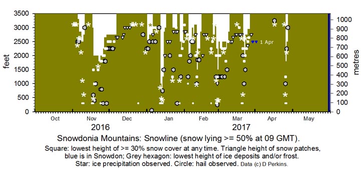
October No snow was observed in Snowdonia, there a fall of snow pellets/ snow on Cairngorm Mountain on the 18th. November
A slight fall of snow pellets/ snow fell on Cairngorm Mountain on the 1st. Showers of sleet and or snow pellets and snow occurred on Snowdon and Carnedd Llewelyn early on the 2nd. There were further wintry showers on the 3rd and 4th around the summits. On the 5th there was slight to light snow lying at 3300 ft on Snowdon and Carnedd Llewelyn and in the afternoon, following snow showers, there was a light deposit on the NE-facing shoulder to the railway line above Clogwyn station. More snow showers on the 6th with snow lying at 2850 ft with light accumulations on the summits. On the 7th snow as low as 2500 ft near the Black Ladders and further snow overnight with snow lying more generally at 2500 ft on the morning of the 8th including slight deposits eastward on the Carneddau including Foel-fras and Drum . Snowdon well covered on N-facing slopes. Wintry conditions with further showers prevailed on the 9th and 10th, but on the 11th snow and ice was mostly limited to small broken areas mainly on the summits. Ice precipitation around the summits on the morning of the 17th and lying at 3000 ft. Overnight showers of snow pellets and snow left light snow lying on the morning of the 18th at 2000 ft with slight deposits at 1500 ft and icy remnants (snow pellets) as low as 300 ft. Showers continued during the day. There was lying snow at 2000 ft on the 19th to 21st then snow most of the day, moderate to heavy at higher altitudes in blizzard conditions. On the 22nd snow lying at 1800 ft with slight cover as low as 1500 ft on some northern slopes. Light snow cover was persisting on the 25th thereafter as broken snow cover lying above 2250 ft on the 26th rising to 2650 ft on the 28th and 2750 ft at the end of the month when there was 30% cover as low as 2500 ft with some ice at 2250 ft. December
The month began with some broken snow lying particularly on the N-facing slopes of the Carneddau in the east of the range. On the 2nd broken snow lying above 1750 ft and 30% at 2500 ft, but there was little elsewhere, persisting up to the 6th when there was a thaw as temperatures increased markedly overnight with temperatures rising to 16.8C in Llanfairfechan at midnight. On the 8th there were several snow patches on N-facing slopes and cliffs of the Carneddau. Temperatures on Snowdon were around 5/7C at 0900 GMT; there was also very little snow left on Cairngorm Mountain. There were isolated patches of snow around summits on the 11th and one as low as 2650 ft under C. Llewelyn on the 12th there after two at 2750 ft on the 13th and one remained until the 19th at 3000 ft. Thereafter although there was frequent ice precipitation around the summits little or none remained for long on the ground. January
A cold front arrived over North Wales at midnight and precipitation fell as snow on the mountains over 2000 ft and on the morning of the 1st was lying at 2500 ft with traces as low as 2250 ft. February
On the 1st there was a little snow above 3100 ft in places with only a few snow patches and pockets of snow left on the mountains. Early on the 3rd snow fell above 2750 ft, with slight deposits seen at 1030 GMT, around the Carneddau summits before they become obscured in further precipitation. On the 4th fresh snow was lying above 2000 ft and as low as 1250 ft briefly early in places including snow pellets and snow on Cadair Idris. There was light snow on the 5th at 1800 ft in places and generally above 2000 ft. By the 6th snow was lying above 2500 ft with some on Cadair Idris as well. On the 7th there were some large areas of broken snow above 2750 ft and many snow patches as low as 2500 ft and lines old cornices on cliff ridges persisting in places. On the 8th there was a sprinkling of fresh snow from showers in places around some summits and slight amounts persisted through 9/10th as low as 2000 ft in places on N-facing slopes of the Carneddau and around Snowdon. On the 11th snow was falling at 850 ft and settling at 1000 ft near at Ogwen and Cwm Idwal with light accumulations occurring above 1500 ft; snow turned to sleet and rain at lower levels, but continued settling at higher levels in showers. On the 12th snow was lying above 2250 ft with a little at settled at 1850 ft in places; snow showers continuing. On the 13th snow was lying 2250 ft with slight deposits as low as 1850 ft. By the 14th snow cover had reduced, but there were several snow patches, some large and old drifts that were still persisting on the 15th above 2000 ft. Snow patches persisted in various places on the Carneddau and Snowdon area. On the 23rd following Storm Doris light snow fell and in the afternoon had settled above 2250 ft. On the morning of the 24th light snow was lying above 2750 ft and as low as 2500 ft on the N-facing slopes of the Carneddau. On the 27th following overnight and early morning showers of hail and snow, fresh snow was lying above 2250 ft on the Carneddau below the Black Ladders and as low as 1250 ft at Cwm Idwal. Several crashes were reported on the A55 and between Gwalchmai and Llanfihangel was for a time closed in both directions, all due to a heavy fall of hail about 08 GMT. Further showers of snow pellets and snow during the evening. On the 28th after more snow had fallen in showers, including snow pellets, sleet and snow at low levels, there was light snow lying above about 1250 ft with slight deposits above 300 ft in some places March
On the 1st there was snow lying at 2500 ft with a 30% cover above 200 ft, but there was snow as low as 1250 ft in places. At higher altitude snow was deeper and in places soft and drifted and was present across the range including the Glyderau and the tops of Moel Eilio and near hills to the west and Cadair Idris above 2000 ft. Fresh snow overnight and on the 2nd snow lying at 2250 ft and again as low as 1250 ft in places and at higher levels was deep and even. Snow was lying on the 3rd at 2250 ft with some broken snow remaining at 1250 ft in the area around Cwm Idwal. Snow on the lower N-facing slopes of the Carneddau was somewhat broken today and sparser on the eastern Carneddau. Snow was falling around the highest summits in the morning. Similar levels prevailed on the 4th although the snow was more broken at lower levels, snow showers on the summits. On the morning of the 5th a band of precipitation moved NE over N Wales with snow on the Horseshoe Pass, Llangollen, and snow was falling as low as 500 ft at Llyn Tegid, Bala and above 2000 ft in N Snowdonia leaving some significant deposits at higher altitudes. On the 6th there was a moderate covering of snow above 2500 ft and deeper in places where drifted and some to be found as low as 1250 ft in places. There was more snow lying at 2250 ft on the 7th and as low as 1800 ft including on Moel Eilio and Cwm Idwal with patches of snow persisting on Cadair Idris. The 8th saw a mixture of rain, sleet and snow at times across the summits, broken snow areas on the tops with deep gully snow on the central section of the N-facing slopes of the Carneddau with deep snow and drifts in places remaining within the Snowdon Horseshoe. On the 9th snow was lying above 2850 ft with 30% cover at 2500 ft. Broken snow at higher altitudes and snow patches remained in places and on the 12th lowest snow patches were at 2500 ft on the Carneddau. Patches rapidly diminishing in size, but several small ones remaining on the 13th at 2650 ft rising to 2750 ft on the 15th to 20th. Around 1715 GMT thunderstorms developed with hail and precipitation turning to snow at higher altitudes later. On the 21st and snow was lying at 2500 ft with 30% cover at 2250 ft on the Carneddau. Heavy showers developed in the afternoon with large hail in places and a mixture of sleet and snow at higher levels. Fresh snow was lying above 2000 ft on the morning of the 22nd, but had settled also at 1000 ft around Llyn Ogwen that by noon had thawed to about 1250 ft. There was snow also hills westward including Moel Eilio at 1750 ft with coverings also eastward including Drum; and on Cadair Idris above 1000 ft. Snow persisted though much reduced on the Carneddau and Cadair Idris until the 26th thereafter snow patches on the north-facing Carneddau until the 28th. Snow patches remained in the area of Llyn Glaslyn on Snowdon. April
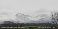
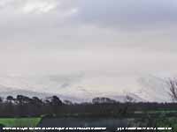
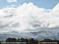
NotesObservations are made as near to 0900 GMT as possible. I have a good view from Llansadwrn, weather permitting, across the Menai Strait towards the Snowdonia Mountains. I can see the northern slopes of the mountain range from Moel Eilio (west of Snowdon), Snowdon summits (Yr Wyddfa and Crib Goch), the Glyderau and Carneddau to Foel-fras and Drum to the east of the range near the Conwy Valley. With the aid of binoculars I make daily records that include any ice precipitation observed, the lowest altitude of snow lying at ( >= 50% cover), at ( >= 30% cover) and snow patches. I aim to update the diagram during the season at least twice weekly if there is any snow.
|


