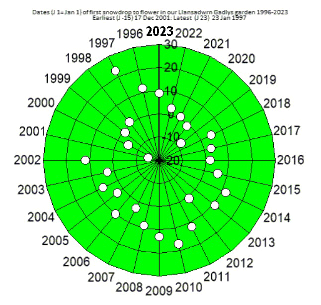
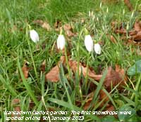
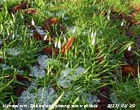
|
Times are GMT (UTC, Z). Observations at this station [ ] are 24-h 09-09 GMT, some others { } occasionally refer to other 24-h periods, extremes (first indications) are usually 21-21 GMT. When averages are referred to (.) compares with the last decade and [.] with the new 30-y climatological average [1981-2010]. All data are subject to verification and amendment. January 2023
January 1 - a fine morning and becoming brighter at the 0900 GMT observations after recent showers of rain. Visibility was very good there was not much in the way of snow on the Eryri Mountains except a few high patches and a sprinkling of fresh ice precipitation on the very tops. A red squirrel was at a feeding box and a raven was croaking on the tallest Scots pine no doubt having a good view of the surrounding countryside. The temperature was 6.1C an overnight minimum and on the grass there had been a minimum of 3.7C. Pressure 1001 mb was rising with low pressure over the UK with 994 mb over the North sea just off Tayside. The sky was darkening in the W with towering cumulus clouds developing over the mountains and to the NE over Liverpool Bay, cumulonimbus were in the vicinity. Llyn Tegid at Bala after much rainfall was full and overflowing flooding the carpark at the visitor centre [Max 8.5C Min 6.1C Rain 5.4 mm]. The 2nd began with little cloud in the sky and though the sun had not risen above cloud huggng the mountaintops brightness was increasing. There was little wind, smoke was drifting from the NW. Visibility was good, there had been a fresh fall of snow and was lying at 2500 ft. Pressure 1016 mb was rising in a ridge from Azores high 1030 mb. A skein of geese flew noisily overhead moving in a north-westerly direction. Rain at Bala (32.4 mm) helped to swell the water in Llyn Tegid keeping the car park underwater. Cloudier around noon, the afternoon had sunny spells turning cloudier with the SW'ly breeze picked up during the evening. The temperature rising reached 4.7C by midnight [Max 9.6C Min 1.2C Grass -1.7C Rain 0.8 mm]. The 3rd was mild overnight and began dull and wet the temperature at 0900 GMT in warm sector air 9.6C highest of the past 24h. A frontal wave was over SW Ireland associated with low 985 mb to the W over the Atlantic. At noon low 998 mb was over Shannon with a warm front over the Irish Sea. Spells of light occasionally moderate rain of 13h duration. Sunless. Wet in Snowdonia (Capel Curig 44.4 mm) [Max 11.4C Min 2.2C Rain 12.4 mm]. On the 4th pressure 1008 mb was rising with low 987 mb over the N North Sea with a cold front over the English Channel. Rain amounts continued to be substantial over North Wales with (40.4 mm) recorded at Lake Vyrnwy. We were in a strong moist SW'ly airflow as depressions pass over northeastwards. Patches of standing water were seen on the Cefni Marsh. Another sunless day [Max 10.8C Min 9.4C Rain 1.2 mm]. Another sunless day on the 5th continuing very mild began with poor misty visibility and intermittent slight drizzle. Pressure 1015 mb was falling with low 990 mb Shannon and a warm front over Anglesey,a cold front was situated off SW Ireland. With the jetstream over Britain another depression 951 mb was over the Atlantic to the W. The cold front passed over during the evening producing a 4C temperature fall as the low 975 mb approached the Western Isles of Scotland. At 1619 GMT the wind reached 40 mph and rain fell at up to 21 mm/h at 1836 GMT [Max 11.3C Min 8.7C Rain 11.8 mm]. The morning of the 6th began with an ugly red sky in the east then was overcast and dull, but it was dry though the ground was very wet even soggy. The last three days had been very mild, today was cooler after a minimum of 6.9C it was 8.2C at 0900 GMT. Red squirrels were running about the garden and visiting the feeding boxes helping themselves to monkey nuts or hazel nuts and hiding away or burying a number. If they don't return for them a few small hazel trees appear from time to time. Deep low 952 mb was to the W of Ireland and warm air returned between 18 and 23 GMT, maximum 11.2C at 2100 GMT, as a wedge of warm sector air passed through, followed strengthening wind and a spell of light rain through the night [Max 11.2C Min 6.9C Rain 6.0 mm]. At midnight on the 7th deep pressure 988 mb was falling with low 949 mb to the W with a cold front over the Irish Sea. The temperature was 10.1C at 0051 GMT before falling erratically and had reached 3.6C by 0900 GMT the wind also moderating. With low 955 mb W of Ireland pressure continued to fall. It was dull and wet the light rain and drizzle continued until 0930 GMT. Some weak sunshine then bright sunshine for a while before the afternoon turned dull with rain at times the temperature reaching a minimum of 6.8C at 1627 GMT. Pressure was lowest 986 mb at 1830 GMT. During the evening the temperature began rising and the wind strengthened again reaching 36 mph at 2145 GMT (Libanus 50.6 mm) [Max 9.5C Min 8.2C Rain 9.0 mm]. The 8th began wet with moderate to heavy rain and poor visibility. Pressure falling again was on 986 mb with complex low 955 mb to the NW. A frontal band over the Irish Sea was moving away by noon when the rain eased. The afternoon remaining cool and quite dull I spent it in the greenhouse cutting back the chrysanthemums that had finished flowering [Capel Curig 16.8 mm] [Max 6.5C Min 3.6C Rain 7.4C]. Showery rain with small ice pellets after midnight on the 9th brought the rainfall total at 0900 GMT to 12.4 mm for the past 24h. The sky was slowly clearing the moderate visibility improving with cumulus clouds developing by 0930 GMT. The sea was rough around the coast and there were pools of water on Cefni Marsh. The sun appeared around noon the temperature 7.3C at 1630 GMT [Valley 21.6 mm 3.6h] [Max 9.6C Min 3.6C Rain 12.4 mm].
The 10th was wet and windy with no sunshine. At 0900 GMT conditions were drenching and dark with zero solar radiation recorded a headlight was needed for the obs. It was milder with strong to gale force winds with gusts of 47 mph here at 1154 GMT and 50 mph at Gorwel Heights, Llanfairfechan. Warm sector air until 1700 GMT when a cold front that was over Ireland moved across (Capel Curig 60.6 mm) [Max 11.7C min 5.0C Rain 15.6 mm].
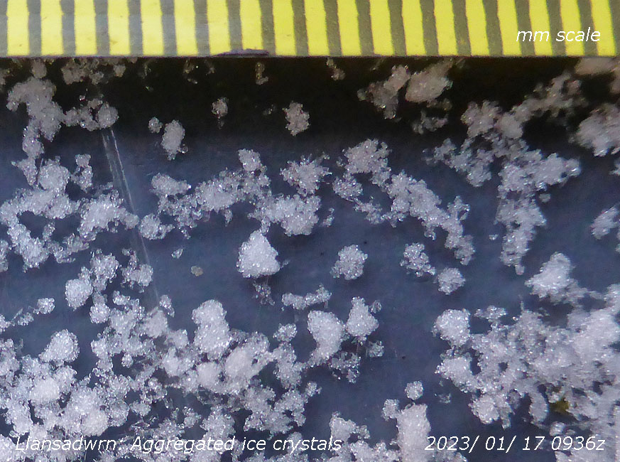
Early on the 17th the ground was covered white with a rare form of small soft hail. It was cold, below freezing -1.4C at 0900 GMT and the hail had not melted. Overnight the air temperature was at a minimum -2.4C at 0700 GMT and on the grass it had fallen to -5.7C, the soil surface was frozen hard with the temperature at 5 cm depth 1.0C. There was some hoar frost on vegetation and rime on the rims of copper raingauges.
After five nights of air frost there was none recorded on the 22nd though with a touch of ground frost -0.7C. Icy remnants had disappeared here, but snow was still lying at 2000 ft on the mountains with remnants at 500 ft. The soil surface was soft and the temperature at 5 cm had risen to 3.9C and there was some submerged ice in water. I had not been collecting much percolate from the lysimeter in recent days it being frozen. Today it had thawed and I collected 145 ml equivalent to 2 mm of precipitation. It was a fine cloudy morning with good visibility, mist and fog was prevalent except around Irish Sea coasts, SW England and NE Scotland. Pressure was on 1031 mb in a slim high pressure area from the Baltic 1040 mb. Contrasting temperatures in the UK today warmer in the north colder 'ice days' in the south (Achnagart 10.9C lo max Chertsey -0.5C Benson min -9.7C and 14.8 mm Weybourne 7.4h Valley 0.0h) [Max 7.3C Min 0.7C Grass -0.7C Pptn nil]. The 23rd began frost-free, cloudy but dry. A mistle thrush was singing in a nearby tree. Pressure remains high on 1035 mb the ridge from the Baltic high 1041 mb persisting. With low airflow in the high pressure particulates air pollution was high in parts of England and wind turbine electricity generation low. Mist and fog was again widespread in central and southern England. Contrasting sunshine and temperatures again (Cassley 12.2C Goudhurst 1.7C Santon Downham min -9.8C Eskdalemuir 5.4 mm Weybourne 7.7h Valley nil) [Max 8.7C Min 5.7C Grass 2.8C Pptn tr]. The month ended with a total of 137.9 mm of rainfall (120%) & [133%] of averages, most since 2021 ranking 27th highest in Llansadwrn since 1928. The mean temperature 6.2C lowest since 2021 and the 10th highest in January station records since 1979. Despite 8 sunless days, sunshine recorded at RAF Valley was 66.5h (136%) & [118%] of averages, lowest since 2021 and 18th on the Anglesey record since 1931.
February 2023
February 1 - a dull day, but it was breezy with wind turbines generating 45% of the UK's electricity demand. Pressure was on 1024 mb with low 980 mb over the S Norwegian Sea while pressure was high 1035 mb over the Atlantic off Cap Finistrerre. A dull and damp day with slight drizzle at times, also sunless but the only day to be so in the month [Max 8.6C Min 6.0C Grass 0.8C Pptn 0.2 mm]. Continuing mild on the 2nd with no overnight frost the result of a wedge of warm air from mid-Atlantic reaching our shores. Pressure was on 1025 mb with pressure high 1035 mb over the Charente Maritime, France. Dull and damp again after recent drizzle fine spots continued on the wind though the sun did appear from time to time later [Max 9.9C Min 7.1C Grass 3.6C Pptn trace]. With some clear sky overnight there had been a moderate ground frost on the morning of the 6th the grass minimum recorded -5.0C, there was frost on the grass and the soil surface was just frozen. Soil temperature at 5 cm depth was 2.8C. There was a light SSW'ly breeze with a few cirrus and cumulus clouds. Pressure was 1042 mb with high 1044 mb SE England. A sunny day here with low pollution, in England there was mist and fog with raised particulate AQI values [Max 8.4C Min 0.5C Grass -5.0C Pptn trace Valley 3.3h]. Another fine morning on the 7th with a little more cloud (5/8) including cirrocumulus and cumulus. The wind was variable, mainly WSW and visibility was moderate with haze. Mist and fog was again affecting central England where high particulates in the air were recorded. The temperature at 0900 GMT was 5.4C, a raven was croaking in the tall Scots pine and the woodpecker was drumming loudly nearby. There was a ridge of high-pressure over S Britain from SE European high 1046 mb it was 1039 mb here. There was a weak cold front over NI and W Scotland where there was a little rain. Sunny spells in the afternoon [Max 9.9C Min 3.3C Grass -0.7C Pptn nil Valley 2.6h]. A cloudier morning on the 8th with 6 oktas cumulus and cirrus clouds. There was a cool SSW'ly breeze the overnight ground frost had disappeared from the grass the temperature being 5.1C in weak sunshine. Visibility was moderate with some haze (AQI 3.4) while there was fog in S Britain with -5C temperature with visibility down to 100 m in places high AQI 8-10 central England. Pressure 1033 mb was falling with low 952 mb over the Norwegian Sea. Pressure was high 1048 mb SE Europe and 1034 mb N Azores. There were tight isobars to the |NWS with storm force winds affecting Scotland and the Northern Isles. A sunny afternoon with light breezes here [Max 7.7C Min 2.5C Grass -3.0C Pptn 0.6 mm Valley cloudy with fog 0.2h]. Hardly a cloud in the sky on the 9th, I spotted a small cumulus cloud over the mountains. Frosty overnight with the grass minimum -4.7C with silver frost and frost still at 0900 GMT with ice on water. Visibility was good, but misty. Particulate levels were moderate to high in SE England with a band of frontal cloud over the S and English Channel. Pressure was high 1035 mb to the SW with a ridge extended to S Ireland and SW Britain it being 1034 mb here [Max 9.8C Min 0.6C Grass -4.7C Pptn trace Valley 8.2h]. The 10th found a warm front over the Irish Sea associated with low 969 mb SE Greenland. Pressure 1034 mb was steady with high 1042 mb over Austria. Dull, breezy and damp with drizzle similar weather prevalent all along the western fringe with SE England sunny [Max 9.3C Min 1.2C Grass -2.2C Pptn 0.45 mm Valley 0.9h]. Another sunless day on the 11th with spells of slight rain and drizzle or slight showery rain. It being so mild I put several chrysanthemum pots with fresh shoots outside the greenhouse to slow their development [Max 9.4C Min 6.9C Grass 7.3C Pptn 0.1 mm Valley 0.0h]. A fine morning on the 12th with brightness increasing. The Austrian high 1040 mb had a ridge to N Wales and N England with pressure here 1037 mb. A very nice day with a light S'ly breeze. The temperature at Gogerddan, W Wales, reached 12.4C. Hive bees were humming on the flowering heathers on the sunny sheltered rockery banks and a few large early bumblebees about as well. Visibility was good and there was little snow to be seen on the mountaintops of Snowdonia. There were a few snow patches surviving with two on Carnedd Dafydd near the cliffs of Ysgolion Duon, the Black Ladders [Max 10.7C Min 6.4C Grass 4.5C Pptn nil Valley 2.9h]. The sky was clear overnight this leading to a white ground frost on the morning of the 13th of -3.6C. There was not a cloud to be seen at 0900 GMT and it was calm. Inversion mist was hanging over the Cefni Marsh and some valley bottoms this clearing to give a sunny day. Sunniest was Aberporth with 8.9h and warmest Kew Gardens 13.6C [Max 11.8C Min 1.3C Grass -3.6C Pptn nil Valley 8.6h]. The 14th began cloudier, there were a few lenticular clouds, with moderate hazy visibility with a light to moderate S'ly breeze. The temperature at 0900 GMT was 10.7C. The day was fine and bright with little sunshine, there was a spell of rain in the morning, the afternoon was brighter when the temperature rose to 13.6C and 16.1C at Gorwel Heights in Llanfairfechan. At Gogerddan, W Wales, 16.4C was reached [Max 13.6C Min 1.5C Grass -3.6C Pptn 0.2 mm Valley 0.3h]. The first 14 days of the month were very dry with only 3.2 mm rainfall (3%) & [4%] of averages. Also mild with the mean temperature 6.9C (+1.0) & [+1.3] of averages. On the 15th there was a cold front over the Irish Sea and it was a bleak day with a moderate SSW'ly wind. Visibility was poor with slight showers of rain. Pressure had fallen and was 1017 mb, but was still high 1038 mb in SE Europe [Max 9.4C Min 8.5C Grass 2.4C Pptn 9.8 mm Valley 1.9h]. A frontal-wave low 1011 mb at Shannon moved over Ireland to the North Channel at midnight there was a burst of heavy rain at 0108 GMT and strong wind at 0304 GMT. On the 16th at 0900 GMT in low cloud fog was thick (code 1, less than 100 m) with slight to moderate drizzle. The temperature was 8.6C and the wet bulb in the Stevenson screen also read 8.6C, 100% humidity. There was a triple point over the Severn estuary associated with the North Channel low. Yesterday's cold front was over France. The fog was slow to lift, a damp and sunless day. At midnight deepening low 987 mb was at Rockall, this had been named storm Otto by the Danish Weather Services (Hawarden 14.6C & 2.7h) [Max 10.5C Min 6.5C Grass 4.5C Pptn 0.4 mm Valley 0.0h]. Pressure 1019 mb was rising on the 17th with storm Otto 981 mb now at Wick deepened further reaching 978 mb when over S Sweden at 1800 GMT. Overcast with poor visibility in mist and rain in the morning, brightening by afternoon with a little sunshine. The first flowers had appeared on the dwarf white Rhododendron on the rockery bank (Pershore 17.2C Achnagart 39.2 mm) [Max 12.6C Min 8.6C Pptn 4.5 mm Valley 2.1C]. Another mild day on the 18th overnight the air minimum was 9.2C and the temperature rose to 10.7C in the afternoon. Dull and damp with slight rain and/ or drizzle with poor visibility. Low Otto 981 mb was now over the Baltic [Max 10.7C Min 9.2C Pptn 0.3 mm Valley 0.0h]. Similar weather on the 19th, mostly cloudy with a WSW'ly wind the cloud had orographic waves to the SE at 0900 GMT. Occasionally brighter, but little in the way of sunshine after its brief appearance rising over the Carneddau Mountains at 0758 GMT. Pressure 1028 mb was rising with complex low 975 SW Iceland and high 1032 mb 500 miles W of Cap Finisterre. A woodpecker spent a little time weakly drumming on the top of the electricity pole and a dark red squirrel was taking hazel nuts from a nearby feeder. Spent the afternoon in my workshop making some new Piche tubes. The markings on the old ones I had made using plastic laboratory pipettes had faded making reading difficult especially with old eyes. The new ones are very clear! (Usk 14.8C) [Max 9.8C Min 4.9C Grass 0.5C Pptn trace Valley 0.0h]. The dark squirrel met me on the path to the Stevenson screen the morning of the 20th, I don't know who was most surprised. After recent intermittent drizzle the sky did look brighter to the SE for a while before returning to intermittent drizzle, we have been getting a lot of drizzle lately of little volume when measured. We were in a W'ly airflow with low 967 Norwegian Sea and high 1034 SE Europe. Two cold fronts straddled Britain while Wales had a slow-moving warm front. The temperature 8.8C (dewpoint 8.0C 95% RH) rose to 10.4C mid-afternoon when the sun broke through [Max 10.4C Min 7.4C Pptn trace Valley 6.1h]. A dry and fine morning on the 21st and continuing mild with a wedge of warm sector air off the Atlantic associated with low 989 mb W of Rockall. Visibility was very good under moderately high altostratus. A cold front lying to the W of Ireland edged closer through the day arriving over the Irish Sea at midnight [Max 9.3C Min 7.4C Pptn 3.8 mm Valley 0.0h]. Cooler by the morning of the 22nd with a little rain that fell as snow on the mountains. In the wood wild garlic is shooting and will soon be large enough to use as salad. Also growing are the bluebells which have leaves about 5 cm tall. It was a clear evening and we had a wonderful dark sky view of the new Moon in close conjunction with Jupiter and Venus. Towards midnight a tawny owl was hooting [Max 7.1C Min 5.3C Grass 3.9C Pptn 4.4 mm Valley 0.5h]. Clear skies overnight resulted in a touch of ground frost -1.0C on the grass with white frost. With the sky clearing overnight there was a ground frost but no white was seen on the 25th at 0900 GMT. A sunny morning with a few cumulus clouds developing over mountains to the S later fair-weather clouds were over the weather station in a cool NE'ly breeze. Pressure was steady on 1022 mb with high 1025 mb 500 miles W of the Western Isles of Scotland. With low 989 mb over the Baltic we had a northerly airflow from the Atlantic via Iceland. The jetstream was well south with a string of depressions heading for the Strait of Gibraltar before being blocked and turning north. Fine and dry here, it was colder with with marine convection bring rain to the east of Britain (Helens Bay max 10.2C lomax Braemar 2.8C Tiree 9.6h) [Max 7.3C Min 2.6C Grass -1.6C Pptn nil Valley 7.1h]. Very fine morning on the 26th the E'ly breeze feeling rather chilly. Pressure 1031 mb was rising with high 1034 mb Scotland. Weak sunshine at first with cirrus and altocumulus clouds increasing, sunny spells developed later [Max 8.2C Min 3.2C Grass -0.2C Pptn nil Valley 4.9h]. The morning of the 27th was fine and dry with 6 oktas of cumulus clouds and an E'ly breeze picking up. With high 1040 mb over Scotland pressure here was steady on 1016 mb. Pressure was low 950 mb S Greenland and 1001 mb western Mediterranean [Max 7.3C Min 3.3C grass -1.2C Pptn 1.0 mm Valley 0.6h]. Snow had been at a premium this month, but this morning the 28th fresh snow had fallen on the Eryri Mountains lying above 2250 ft on the Carneddau and Nant Ffrancon Pass. Yr Wyddfa was well covered, but less at fallen towards Drum in the E of the range and was a higher altitude. Pressure was on 1038 mb with the Scottish high 1041 mb at Cape Wrath. Snow had fallen in parts of the Mediterranean including Spain and Morocco as a result of storm Juliette 998 mb over the Balearic Islands. Here, recent light showers of rain gave way to sunny spells [Max 8.7C Min 4.6C Pptn 0.3 mm Valley 2.2h]. The month ended with rainfall of 28.7 mm (25%) & [32%] of averages, lowest since 2009 making it one of the 13 driest Februarys on record in Llansadwrn since 1928. Temperatures finished above the averages with the mean 7.2C (+1.3) & [+1.6] of averages highest since 2019 and ranking 3rd in station records since 1979. It was generally a dull month with sunshine at RAF Valley 69.7h (81%) & [89%] of averages.
March 2023
March 1 - began dull with spots of rain and moderate visibility. St. David's Day, there were plenty of daffodils in flower in the garden this year and a good crop of leeks on the vegetable patch. The jetstream was well south of the UK over Africa. The 6th began dull with low cloud on mountain slopes good visibility turning misty with rain or drizzle at times. Pressure 1006 mb was falling, there was a low 998 mb over the North Sea off Wick and a cold front N Irish Sea. Very dull under thick cloud with slight rain or drizzle, occasionally trying to brighten. The cold front crossed N Wales around noon when the temperature was 7.2C, then falling slowly reaching 2.8C at 2200 GMT. Caernarfon Airport reported snow late evening [Max 7.2C Min 4.3C Pptn 3.8 mm] [Milford Haven 9.6C Lake Vyrnwy 0.9C Pptn St Athan 22.0 mm & 1.1h Valley 0.0h]. An early shower of snow pellets and snow on the 7th left remnants scattered about. Snow was lying on the Snowdonia Mountains above 1500 ft, 50 cm deep in places, with 30% cover at 1250 ft and some as low as 250 ft. Bright at 0900 GMT with cumulus clouds developing and a cumulonimbus in the vicinity with sunny spells. Heavy snow in South Wales and Scotland with many schools closed. A sunny and warm afternoon if out of the north wind. Dug up a good helping of leeks from the vegetable plot, steamed for dinner they were of excellent flavour [Max 6.5C Min -0.2C Grass -3.9C Pptn nil] [Mumbles Head 8.1C & 4.0 mm Lake Vyrnwy -0.9C Aberdaron 7.6h Valley 6.7h].
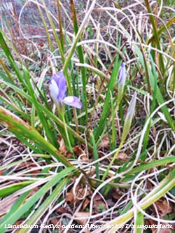
Snow continued to fall on the 10th at all levels with some drifting taking place at higher levels. Snow on the ground at the weather station at 0900 GMT measured 2 cm with further accumulations on the Snowdonia Mountains. Capel Curig reported 27 cm, Lake Vyrnwy 15 cm; Hawarden and Bala 5 cm. In N England Thorncliffe, Staffordshire 23 cm and Bingley, West Yorkshire 14 cm. The blue flowers of Glory-of-the-snow covering the rockery banks were poking through the snow (below left) [Max 6.6C Min 0.3C Grass -0.6C Pptn 0.3 mm] [Milford Haven 7.3C Lake Vyrnwy -2.1C Capel Curig 11.8 mm Aberdaron 8.2h Valley 7.1h]. The first 15 days of the month were wet with 74.4 mm rainfall (82%) & [95%] of averages. Also cold with the mean temperature 4.8C (-2.0) & [-2.2] of averages. Wet and windy on the 16th, but turned very mild. Air temperature approached 10C at midnight and was 10.2C at 0900 GMT and rather blustery. After intermittent light to moderate rain there was 7.4 mm in the raingauge. Visibility was poor and it was still raining, it wasn't bothering the red squirrels, but I didn't care for it. Three individuals Darky, Red and Patch preeminent at present.. Complex Atlantic-low 976 mb to the SW with tight isobars on the chart, gust of 54 mph at Capel Curig this morning. We were in warm sector air, but a cold front was charted over the Celtic Sea [Max 10.6C Min 4.3C Pptn 1.0 mm] [Hawarden 13.0C Sennybridge 6.7C Capel Curig 19.2 mm 0.0h]. Fine, bright and breezy to begin the 17th with a UK temperature range this morning 4-13C. Pressure was on 999 mb with Atlantic-low 983 mb off SW Ireland. An occluded front over the Irish Sea was associated with a low just off S Norway 988 mb. Sunny spells and light showers otherwise pleasantly warm, 16.3C recorded in Llanfairfechan and Pershore provisionally highest in UK [Max 14.2C Min 9.1C Pptn 1.2 mm] (Pershore 16.3C) [Bodelwyddan 15.7C Lake Vyrnwy 6.7C Capel Curig 6.2 mm Hawarden 4.9h Valley 1.5h]. Showers of rain overnight, but a bright morning on the 18th with some weak sunshine. Visibility was a misty moderate to good with fog around the west coast with some drizzle. Temperatures around the UK between 6-13C rising to 13.8C here in sunshine at 1349 GMT. With cumulus clouds in the vicinity the afternoon turned showery [Max 13.8C Min 8.6C Pptn 1.8 mm[ [Bala 13.1C Trawsgoed 6.6C Hawarden 5.8 mm Valley 3.4h]. Dry with some clear sky overnight and with little wind a touch of ground frost. A mostly cloudy morning on the 21st with poor misty visibility. Pressure was 1003 mb with complex low 972 SW Iceland and a cold front along the spine of Britain. A shower front was over Wales and the day was blustery with the SW'ly wind strengthening to gale force. Strong gusts recorded 45 mph here and 46 mph at Gorwel Heights. Later Capel Curig reported 71 mph with a cold front over the Irish Sea the low 970 mb to the north-west [Max 12.0C Min 9.1C Pptn 14.0 mm] [Hawarden 14.2C Lake Vyrnwy 7.5C Valentia 34.0 mm Capel Curig 28.2 mm Valley 4.5h] [Ny Alesund -19.0C/ -20.9C Snow 49 cm; Tromso 0.4C/ -2.9C Snow 140 cm].
The 29th began dull with spots of rain and drizzle blowing on the moderate SSE'ly wind. Pressure 1004 mb was falling quickly with complex low 973 & 975 mb over the Atlantic W of Ireland. A triple point was over the Scilly isles with an occlusion over the Severn estuary while a cold front was over SW Ireland. Heard the chiffchaff singing rather weakly once or twice. Blustery at times with slight rain in the morning the temperature here reached 13.3C at 1114 GMT. In Llanfairfechan it reached 16.9C at 1127 GMT highest of the year so far, the provisionally the highest reported in Britain on the day. The blustery afternoon, 32 mph at 1642 GMT, remained dull with more rain coming along in the evening turning heavy 33 mm/h at 2129 GMT [Gorwel Heights 16.9C Gorddinog AWS 16.9C] (Derryln Cornahoule 16.2C Libanus 23.6 mm) [Max 13.3C Min 7.8C Pptn 15.5 mm]... A wet month with rainfall of 146.6 mm (161%) & [187%] of averages, largest since 2019 making it one of the sixth wettest on record in Llansadwrn since 1928. Mean temperatures finished close to the averages similar to February with the mean 7.1C (+0.3) & [+0.1] of averages lowest since 2020. It was generally a dull month with sunshine at RAF Valley 85.6h (66%) & [71%] of averages.
April 2023
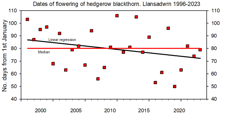
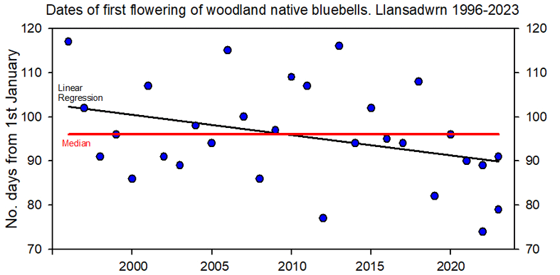
April 1 - began with the first native bluebells appearing in the wood latest since 2020, but five days earlier than the median date. Records kept since 1996 though variable like blackthorn show a weak trend towards earlier flowering, some 12 days earlier in recent years
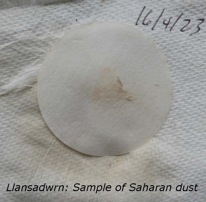
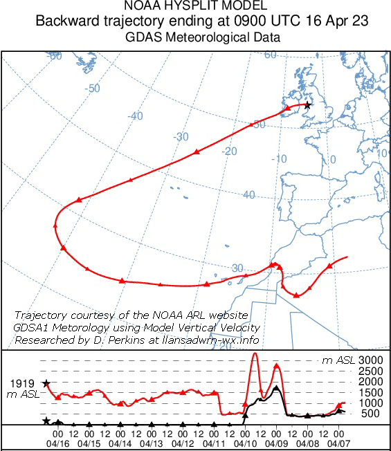
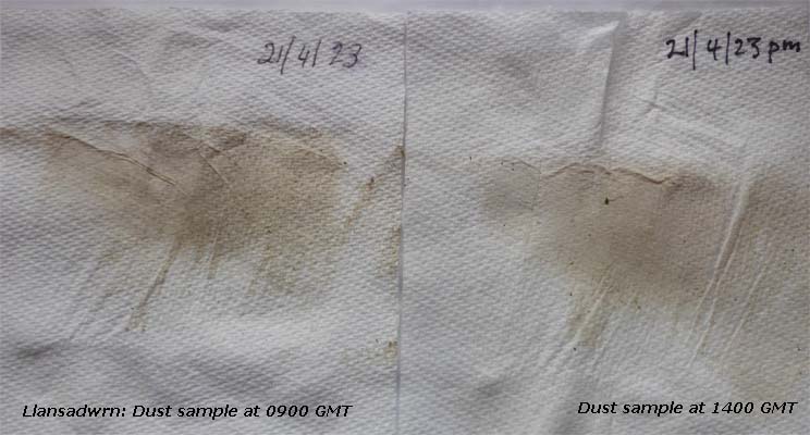
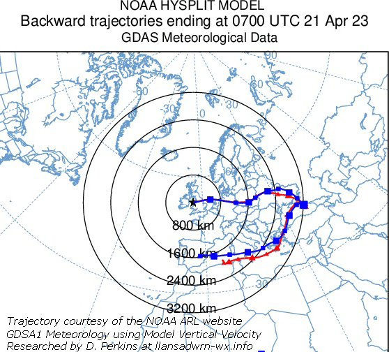
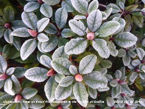
The 12th was both the wettest and coolest day of the month. Snow had fallen on the mountains of Eryri and was lying at 1000 ft at Llyn Ogwen and smaller amounts covered the lower slopes of the Carneddau above 850 ft. Snow had also fallen in the Isle of Man. At 0900 GMT here there was some patchy snow on the ground in places following heavy precipitation of sleet and snow 7.8 mm/h at 0841 GMT, the temperature was 2.3C, the lowest of the past 24h, and visibility poor. Pressure was on 982 mb falling to 979 mb at 1039 GMT with twin depressions 978 mb S Ireland and 972 mb N Scotland. Strong to gale-force winds in the west particularly in South Wales with Mumbles Head reporting f9 56 mph mws and gusts of 71 mph. Here the wind was moderate to strong southerly. At 1046 GMT there was more heavy ice precipitation 18.8 mm/h and at 1150 heavy snow pellets covered the ground to a depth of 2 cm. Sferics were recorded over the Severn estuary, Gloucester and N Devon, the London area and Edinburgh [Max 8.8C Min 2.3C Grass 1.4C Pptn 9.2 mm] [St Athan 10.5C Lake Vyrnwy 0.1C Capel Curig 17.7 mm Bala 3.4h Valley 3.0h]. The first 15 days of the month had 32.4 mm rainfall (72%) & [49%] of averages. Temperatures were a little below the averages the mean 8.5C (-0.7) & [-0.6]. The 16th began overcast after recent rain the visibility very good under the cloudsheet. There had been a fall of light coloured Saharan dust in the rain and the air was clear from the haze of recent days. Just before and after midnight on the 17th fog developed, but had cleared by morning the sky overcast. Pressure was on 1029 mb in a ridge to Brittany from high 1036 mb S Norway. Remnants of frontal cloud/ fog over the North Sea were impinging upon the east coast of England. Dull and damp at first becoming brighter in the afternoon and feeling warm in sunshine before turning cooler as 'haar' mist encroached from the east. Later in the evening thick fog developed [Max 15.1C Min 8.2C Rain nil] [Kinlochewe 21.1C Gorddinog AWS 17.1C Milford Haven/ Gorwel Heights 16.1C Lake Vyrnwy 7.7C NSR Aberporth 2.2h Valley 0.6h]... Pressure 1015 mb was falling rapidly on the morning of the 21st with the moderate NE'ly producing quite a wind chill 4.4C in the early hours. At 0900 GMT the temperature was 10.3C dewpoint 7.9C the sky with cumulus and altocumulus had been clearing becoming bright, but now cloud was increasing again. Visibility was poor with thick haze. The UK temperature range 4C Sennybridge to 15C in Cumbria and the north. Pressure was high 1033 mb over S Norway while Atlantic-low 978 mb was N of the Azores. Detached occluded cloud was charted lying over Wales and East Anglia to the North Sea and then circling to the Cote d'Azur. No precipitation was found in the raingauges, the ground had looked slightly damp about 0700 GMT, but had dried quickly.
The month ended with rainfall of 53.0 mm (118%) & [81%] of averages, largest since 2019. Temperatures finished a little above the averages with the mean 9.4C (+0.2) & [+0.3] of averages lowest since 2021 and ranking 16th highest in station records since 1979. A fairly sunny month with sunshine at RAF Valley 166.1 h (90%) & [101%] of averages, the sunniest day 13.3h on the 20th.
May 2023
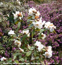
May 1 - after a quiet night the month began mostly cloudy but fine and the day brightening. The temperature at 0900 GMT was 12.1C the UK temperature range 5C in the N and 15C in the SE of England. Pressure 1019 mb was rising in a ridge over the Celtic Sea from high 1023 mb the Bay of Biscay. A cold front over Scotland associated with low 1006 mb over the Baltic brought lower temperatures in the N it was 7C in Newcastle in the afternoon. Here the temperature rose during a sunny afternoon to 15.8C at 1550 GMT (Cardiff 19.7C) [Max 15.8C Min 9.6C Grass 8.5C Rain trace] [Valley 8.0h].....
The first 15 days of the month were on the dry side with 18.2 mm rainfall (25%) & [27%] of monthly averages. Temperatures were above one degree above averages the mean 12.7C. The 16th began mostly cloudy with a light ESE'ly breeze. Pressure was on 1028 mb within high pressure area 1030 mb Shannon. Frontal bands N of Scotland associated with low 1001 mb over the Norwegian Sea. Low 995 mb over Italy named Storm Minerva with torrential rain causing devastating flood damage to property and 9 deaths in the Po Valley, including in Ravenna. The River Po is fed from several high mountain lakes. Rimini reported 96 mm, Bologna 74 mm rainfall. Some sunny spells here in the afternoon and keeping dry [Max 16.3C Min 5.8C Grass 3.7C] (Usk 19.5C) The 20th began with a few clouds, some cirrus and cumulus clouds started bubbling up over the mountains, but subsided later. A new bird record for the station list when two red kites were spotted overflying at 0900 GMT. Reported around Anglesey for a while the first sighting here. The temperature was 16.8C and there was a gentle ESE'ly breeze. A warm and sunny day the temperature rising to 19.0C, but in Porthmadog 21.5C was recorded [Max 19.0C Min 9.8C Rain nil]. The warmest day so far this year on the 21st with 20.4C recorded at the station and 23.3C in Porthmadog the latter highest in the UK so far this year. Beginning mostly cloudy, but bright with good hazy visibility, pressure was steady on 1025 mb. A large Atlantic-high 1034 mb stretched from SE Nova Scotia past the Azores with a ridge to the Western Isles linking the UK to Baltic high 1030 mb. A cold front lay over Ireland with associated cloud affecting Irish Sea coasts. The cloud burnt back by the afternoon which was sunny. Air particulate levels were slightly elevated, PM2.5 4.0 µg per m-3 here, around Irish Sea coasts, moderate in the Netherlands and parts of Europe. Ozone levels were moderate with 24-h mean Marchlyn Mawr reservoir 2100 ft where an instrument recording ozone (Air Quality in Wales) 24-h mean measured 79 µg per m-3 [Max 20.4C Min 10.6C Rain nil] (Porthmadog 23.3C Sennybridge 1.3C).
The month of May ended with rainfall of 18.6 mm (25%) & [27%] of averages, the second lowest in 96 years in Llansadwrn. The lowest was in 2020 when just 11.9 mm fell. Temperatures over a degree above averages with the mean 13.0C [(+1.2)] of averages highest since 2017 and ranking 6th highest in station records since 1979. A sunny month with sunshine at RAF Valley 276.4 h (126%) & [137%] of averages second highest on the Anglesey record back to 1931, the highest was in 2020, the sunniest day 15.2h on the 31st.
June 2023
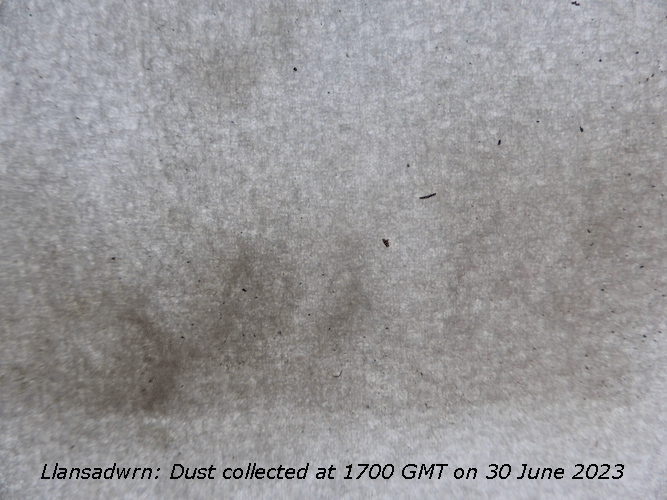
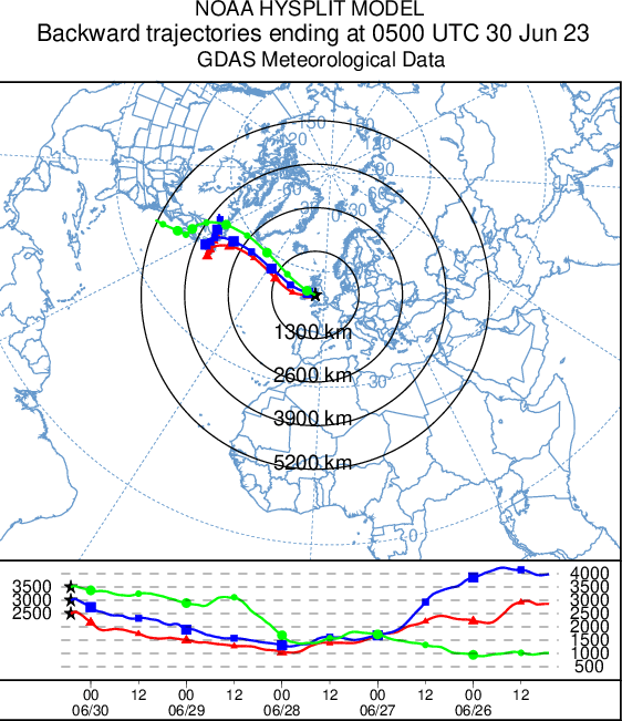
June 1 - a fine morning with a cloudless sky the remarkable spell of weather continuing. Pressure was steady on 1030 mb with stable Atlantic-high 1036 mb lying to the NW S of Iceland. There were some weak decaying fronts over Scotland while there were slight showers in E and SE England. Low 1013 mb was over the western Mediterranean and Biscay where the weather was unusually unsettled for the time of year. Temperatures this morning ranged from 9C at Lake Vyrnwy to 19C at Shannon. Here the temperature 13.1C rose to 15.8C in the afternoon in a strong N/NE'ly breeze off the sea. At Gorwel Heights AWS 18.8C was recorded and at Gorddinog AWS 20.7C. Visibility was good, but with moderate haze, the ozone concentration at Marchlyn Mawr reservoir 2100 ft (Welsh Air Quality Forum) measured 130 µg per m-3 [Max 15.8C Min 9.3C Rain nil] (Porthmadog 24.9C Valley 15.1h)... The 10th began with scattered cirrus and cumulus clouds and already warm, the temperature at 0900 GMT was 23.3C. Pressure was steady on 1012 mb with a thundery low 1010 mb over the Atlantic to the SW lying off Cap Finisterre and Brittany 1010 mb where thunderstorms were developing. In unstable conditions storms broke out in central England N of Gloucester and spread along the Welsh Marches reaching Cumbria and Morecambe Bay where slow-moving and intense, later reaching Scotland where they died out. In the afternoon the temperature here reached 25.7C and 29.3C at Gorwel Heights, 29.8C at Porthmadog and 30.3C at Gorddinog AWS. Slight rain fell during the evening from c. 2030 GMT and rumbles of thunder were heard 2245-2300 GMT [Max 25.7C Min 13.7C Rain 0.65 mm] (Chertsey Abbey Mead 32.2C Crosby 16.0 mm) [Hawarden 29.4C Bala 8.1C Hawarden 15.8 mm & 11.1h Valley 7.9h]... The 15th began with hardly a cloud in the sky and already warm at 0900 GMT it was 23.5C and very good visibility and a gentle breeze from the NE had begun. Pressure was steady on 1020 mb, the day was sunny and warm the maximum 27.4C highest of the year here so far. Bees had been busy and pods had formed on some broad beans on the vegetable plot [Max 27.4C Min 13.8C Rain nil] [Usk 28.8C Bala 8.8C Sennybridge 0.8 mm Valley 14.0h] The first 15 days of the month began sunny and very warm the mean temperature 16.4C (+2.0) & [+2.4} of the monthly average. The mean maximum 21.4C was +3.7 on the last decade, the highest maximum was 27.4C on the 15th. Continuing on the dry side with 23.2 mm rainfall [(32%)] of averages. The 16th began sunny and warm the temperature at 0900 GMT 23.6C. A few small cumulus clouds formed overhead in convergent airflows cleared, but it became cloudier around noon and later overcast with a few spots of rain. Pressure was on 1018 mb with Atlantic-low 1008 mb W of the Bay of Biscay and ab occlusion developing over the Irish Sea at noon [Max 26.8C Min 13.7C Rain 7.8 mm] [Mona/ Hawarden 27.1C Sennybridge 9.9C Mona 10.8 mm Hawarden 10.8h Valley 7.1h]. With the low 1007 mb W of the Scilly Isles and occlusion over the Irish Sea showery rain after midnight on the 17th turned moderate to heavy 12 mm/h for a while around 0345 GMT. Daily rain measured at 0900 GMT was 7.8 mm the most in 24-h since 29 April when 8.6 mm fell. It was welcome in the garden which is very dry indeed. The temperature cooler than of late was 15.6C and very humid 94%. There was a cold front over southern Ireland where sferics were observed. Pressure was on 1014 mb and pressure was high 1026 mb near the North Cape, Norway. The jetstream that has been far S over Africa fro a long while, though now weak, is positioned over southern Britain. Showers came along in the evening and there was thunder and lightning here 2250-2320 GMT with heavy rain falling at a rate of up to 50 mm/h in a short spell. A rare earthquake in the Charente Maritime in France 510 mi SSE of here 4.9 M at a depth of 3.1 mi (USGS) damaged a church and houses in the village of La Laigne where a wall was reported to have shifted 12 cm [Max 22.2C Min 13.8C Rain 5.8 mm] [St Athan 24.7C Aberdaron/ Mona 13.6C Sennybridge 13.0 mm St Athan 5.3h Valley 4.5h]. A fine morning on the 29th with a few cumulus clouds and sunny spells. Visibility was good and the temperature 16.6C at 0900 GMT. A family of chiffchaff were around the garden during the day. Soil conditions still dry when I planted 5 rows of leeks it was hard to make the holes in the dry soil to plant them and they needed watering in [Max 20.0C Min 11.4C Rain 0.7 mm] [Mumbles 21.0C Bala 8.4C Pembrey Sands 2.4 mm Capel Curig 2.2 mm Gorwel Heights 1.2 mm Aberdaron 10.2h Valley 9.5h]The 30th began overcast with a blustery SW'ly wind, poor visibility and slight rain or drizzle from early hours. At 0900 GMT pressure 1009 mb was falling with low 996 mb anchored at Iceland and Atlantic-high 1036 mb N of the Azores, warm fronts were charted over the Irish Sea. A deposit of a dark grey to black dust was collected that was streaky when rubbed like charcoal. The month ended with rainfall of 39.1 mm (54%) & [53%] of averages, largest since 2018 ranked 16th least since 1929. Temperatures finished highest in station record for June since 1979 with the mean 16.9C (+2.4) & [+2.8] of averages. A sunny month with sunshine at RAF Valley second highest on the Anglesey record since 1931.
July 2023
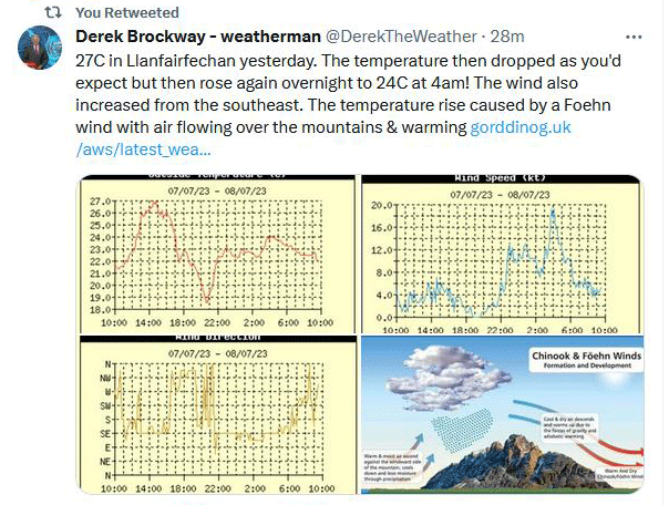
July 1 - an unpromising start to the month with overcast sky touching the Eryri summits with spots of drizzle or slight rain. Pressure was on 1006 mb with a depression 993 mb between Iceland and Scotland and frontal cloud over the west of Britain. There was a large high 1033 mb over the Atlantic west of Iberia. Damp and dull at first, cooler than of late, some sunshine later [Max 19.2C Min 12.9C Rain trace] [Pembrey Sands 19.8C Lake Vyrnwy 12.7C Capel Curig 1.0 mm St Athan 8.1h Valley 3.7h]. TThe 7th began dull and breezy with a S'ly wind. Pressure 1012 mb was rising with lows 985 mb W Scotland and 991 mb W Biscay. There was a warm front over W Scotland and NW Ireland. The day brightened up with sunny spells developing, it was warm the Föhn enhanced temperatures rising to 25.0C at 1541 GMT here and in Llanfairfechan at Gorddinog AWS 27.0C was recorded at 1432 GMT and 26.2C at Gorwel Heights at 1630 GMT. Both highest of the month [Max 25.0C Min 14.5C Rain nil] [Trawsgoed 26.7C Lake Vyrnwy 12.7C NSR St Athan 13.7h Valley 5.7h]. The coolest day of the month was on the 18th, the day had begun overcast with some rain the temperature at 0900 GMT 12.9C and staying cloudy the maximum struggled to reach 15.2C just before 14 GMT. temperatures around the Mediterranean have been high with 44.3C recorded in Spain today [Max 15.2C Min 123.9C Rain 8.6 mm]
The 25th had the lowest overnight minimum of 9.0C and the lowest grass minimum of 5.0C, but the day was mostly sunny especially in the afternoon [Max 19.1C Min 9.0C Grass 5.0C Rain trace] [valley 8.0h] The month ended with rainfall of 161.0 mm (202%) & [207%] of averages, largest since 2020 ranked 5th largest in Llansadwrn records back to since 1928. Twenty four Julys have now had more than 100 mm. A cooler month than last with the mean 15.5C (-0.80) & [-0.3] of averages lowest since 2020 ranking 20th in station records since 1979. Sunshine at RAF Valley was below average the 158.3h lowest since 2020.
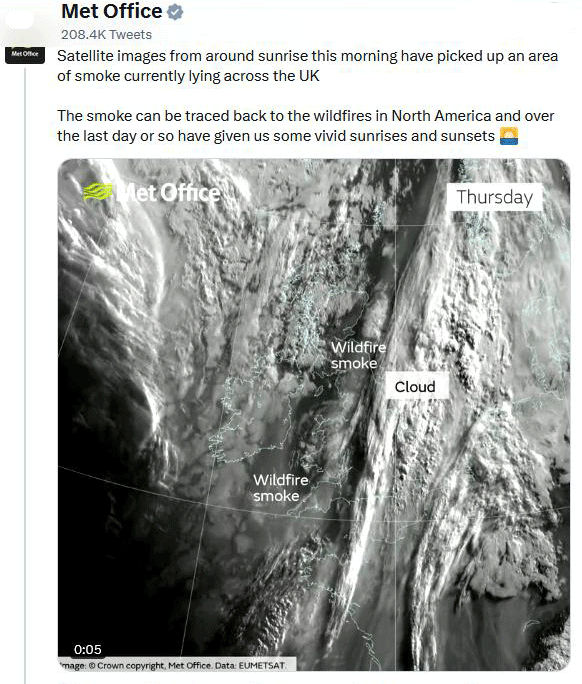
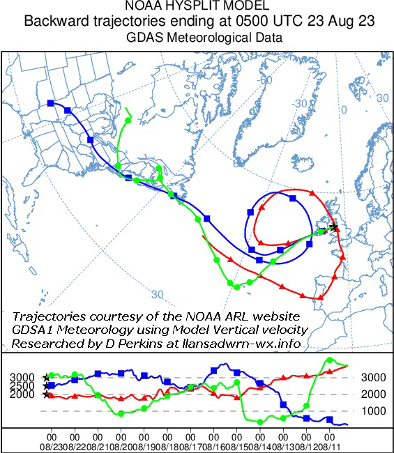
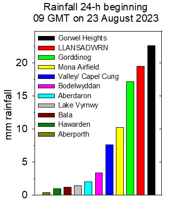
August 2023August 23 - the day began with skies overcast and there had been a spell of rain from 0500 GMT that had ceased, but at 0900 GMT when 1.7 mm rainfall was measured slight rain and drizzle had started again. There was a trace deposit of dust appearing a mixture of greyish black and light reddish colour. Another wet month ending with rainfall of 134.4 mm (137%) & [148%] of averages most since 2020 and rankling 15th in Llansadwrn records kept since 1928. The wettest day was on the 13th having 28.4 mm. The mean temperature 15.9C [(+0.3)] lowest since 2021 ranked 14th highest in station records since 1979. Highest maximum 24.4C on the 10th and lowest minimum 9.3C on the 6th. Sunshine was just about average with RAF Valley recording a provisional 165 h of sunshine least since 2021.
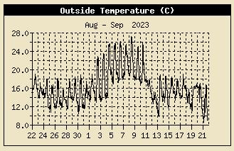
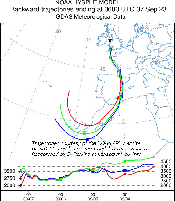
September 2023The 2nd to the 10th saw a remarkable 9-day spell of fine warm to hot sunny weather with maxima >20C with 7-days >25C. Pressure was relatively high during this stable period, highest 1028 mb on the 3rd - 1024 mb on the 13th, before beginning to decline after the 15th. On the 7th pressure was high 1028 mb E Europe and low 998 mb over the Atlantic to the SW this having the effect of drawing to Britain dust laden warm air from the Mediterranean and north Africa.
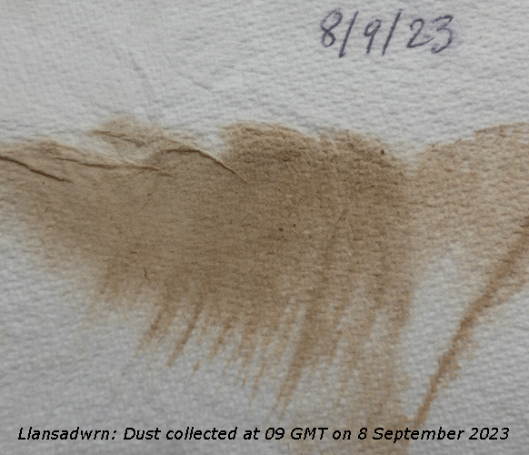
The ten days 5th to 14th had deposits of dust collected every day at 0900 GMT that originated in the Sahara desert, the highest number of consecutive days I can remember seeing. The 15th began mostly cloudy and although appearing bright at times at first eventually remained overcast and rather dull. Pressure was steady on 1014 mb with low 998 mb S Norwegian Sea, an associated warm front linked with frontal-wave 1007 mb off Cap Finisterre lay over the N Irish Sea and Anglesey. Temperatures this morning ranged from 9C in the N to 21C in the south-east. Here 15.8C with 93% RH. It kept dry all day with a maximum 17.9C. Rain came along in the late evening, light showers from 2300 GMT before turning heavy after midnight [Max 17.9C Min 13.7C Rain 10.6 mm]... The first 15 days of the month began sunny and very warm the mean temperature 15.8C goodness me a remarkable [(+4.5)] above the monthly averages. The mean maximum 22.4C (+5.2) & [+5.1] and the mean minimum 14.7C (+3.7) & [+4.0] of averages, the highest maximum was 27.4C on the 15th. There had been 39.9 mm of rain (43%) & [39%] of averages mostly falling after the warm spell.
The 16th began brightly and fresher here with pressure on 1015 mb. Visibility was misty and very poor here and fog was widespread in parts of southern Britain. There was a slow-moving warm front over N Irish Sea associated with a low wavy frontal system stretching from the Norwegian Coast 1005 mb to Cap Finisterre 1001 mb. The temperature ranged this morning from 10C in the cooler north-west to 24C in the south-east, here 14.6C at 0900 GMT rising to 18.0C soon after noon when sunny. Thereafter becoming dull with the temperature falling to 14.3C at 2200 GMT [Max 18.0C Min 13.2C Rain 3.1 mm]. A showery morning on the 17th with pressure 1012 mb falling and a generally E'ly wind. There was a thundery Atlantic-low 997 mb just off Iberia with shower troughs moving N into SW England and Wales. Pressure was high 1024 mb S Norway and there was a deep low 968 mb SE Greenland. The temperature reached 19.0C in brief sunshine at 1320 GMT. Showery rain from 1630 GMT turning moderate to heavy by 21 GMT [Max 19.0C Min 13.8C Rain 25.6 mm]. The 27th began calm enough with a light SSE'ly breeze, it was dull the sky overcast, but it was dry. Pressure 1010 mb was falling rapidly and the well forecast Atlantic-low named Agnes was expected. September ended with a total rainfall of 174.7 mm, the wettest month of the year so far. Largest rainfall since 1976 that had 179.8 mm ranking 4th largest in Llansadwrn records since 1928. It was also the warmest September on record at the station since instruments were set up in 1979, the mean temperature was 16.4C. The mean maximum 19.7C was highest since 2007 that ranking 2nd. The mean minimum 13.2C was a record. Sunshine at RAF Valley was 144.1h (provisional) the 4th was the sunniest day with 12.2H and there were 6 sunless days. October 2023. October another wet month ended with 161.2 mm (110%) & [125%] of averages, but was least since 2018 ranking 22nd largest in Llansadwrn records. Temperatures were above normal with the mean 12.4C though lowest since 2021 ranked 8th highest in records. With the highest maximum of 21.4C on the 18th the annual mean was running at nearly 12C, the highest on record. There was no frost in the month. A dull month with 94.3h (provisional) at RAF Valley lowest since 2021 ranking 41st on the Anglesey record since 1931.
November 2023. November was a very dull month with 10 sunless days just 44.3h of sunshine were recorded at RAF Valley, least since 2015 and ranking 20th lowest on the Anglesey record. Rainfall was 122.6 mm (89%) & [92%] of averages, least since 2021 rank 26 largest since 1928. The mean temperature was 8.1C lowest since 2019 rank 18th highest since 1979. There were 8 days with ground frost the lowest -2.5C on the 25th. Sleet was seen on the 28th and 29th with snow on the Eryri mountains.
December 2023December 1 - began very fine, cold and sunny after a clear night there was a hard ground frost of -5.7C and with an air frost of -2.8C there was hoar frost on low herbaceous plants in the garden. At 09 GMT the temperature in Llansadwrn was -1.0C, in Newcastle the temperature was -4C and in Wilmslow -6C with Shap Fell recording a minimum of -9.4C. A rather dark morning on the 11th and after a recent slight shower of rain the sky was beginning to open up. Visibility was moderate to good, but misty. The temperature was 7.6C in the UKTR 0C/12C north to south. Pressure 1003 mb was rising low 989 mb had an associated occluded front over the Irish Sea. There was a minor ridge west of Ireland and the sky continued to clear slowly into the afternoon and lifting above Eryri mountaintops later. A few snow patches could be seen with remnants of ice/ snow above 2750 ft on the Carneddau [Max 10.6C Min 7.1C Grass 2.9C Pptn 11.6 mm) (Milford Haven 13.2C Lake Vyrnwy 6.3C and 8.2 mm Aberdaron 5.5h). Pressure had been falling overnight and on the 12th around 0530 GMT there was a heavy shower of rain (falling up to 70 mm/h). At 0900 GMT it was raining hard and with the now saturated ground there was standing water. Pressure was on 994 mb with low 991 mb Shannon, pressure was high 1024 mb over north Africa. Rain ceased by 13 GMT and with the sky clearing the afternoon kept dry with a few sunny spells developing [Max 8.9C Min 5.2C Pptn 17.6 mm] (Usk 11.5C Lake Vyrnwy 5.6C Capel Curig 36.7 mm Valley 1.0h). After a shower of rain at 0900 GMT on the 13th with a light to moderate N'ly breeze the sky began to clear. Pressure 1008 mb was rising rapidly with low 994 mb over the NE entrance to the English Channel. High 1035 mb N of the Azores had a ridge towards W Ireland. The temperature was 7.2C +95% RH moderate misty visibility. UKTR this morning -6C/10C far N Scotland to Cornwall and the Scilly Isles.. Almost clear sky later in the afternoon and after dark the temperature fell to 3.0C by 2100 GMT with a ground frost developing -1.0C. Cloud then encroached and by midnight temperature was 4.3C with pressure steady on 1017 mb [Max 9.2C Min 5.6C Grass -1.0C Pptn 2.2 mm] (Scolton 10.7C Sennybridge 2.1C Milford Haven 10.0 mm Hawarden 5.2h). Pressure 1018 mb was rising on the morning of the 14th, but it turned out disappointing day to finish off jobs in the garden as openings in the cloud cover at 0900 GMT soon disappeared leaving a grey day with drizzle and spots of rain at times typical of the western fringe. Needs must, and although unpleasant I didn't get terrible wet. We were in warm sector air so it wasn't cold 8.7C with low 956 mb N Iceland and high 1033 mb NE Azores hence the WSW'ly wind [Max 9.1C Min 3.0C Pptn 0.2 mm] (Cardiff 12.4C Sennybridge -2.1C Porthmadog 5.6 mm St Athan 1.6h). A similar day on the 15th cloudy and dull with thinner patches seen overhead at 0900 GMT soon thickening again. Quite dark in the mornings nearing the solstice just 11 W so reading the thermometers was challenging, brightest 139 W/m² at 1110 GMT. The cloud was moderately high well above the mountaintops there were some remnants of snow high on the Carneddau and the odd small snow patch. Not bad for working outside in the afternoon until about 1530 GMT when it was getting too dark. Wind strengthened later bringing along a little rain [Max 10.5C Min 6.2C Pptn 1.1 mm] (Milford Haven 11.7C Llysdinam 0.5C Capel Curig 1.8 mm Aberporth 1.4h). The first 15 days of the month after a cold start and 22.2h of air frost had a mean temperature of 6.3C (-0.6) & [+0.6] of the monthly averages. Rainfall was 84.8 mm (51%) & [62%] of the monthly average total.
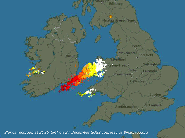
Low cloud mist and drizzle on the 16th, but the sky was lighter in the east towards Conwy. Continuing mild with high-pressure here steady on 1036 mb. Pressure was high 1044 mb SE Europe and the intense low-pressure storms to the north crossing the Norwegian Sea 959 mb. The 21st began dull and breezy the W'ly force 5/6 with Capel Curig reporting a gust of 66 mph. Visibility was poor with spots of rain and mist. The UK temperature range this morning was 6C/13C N-S and here it was 10.6C. A little brighter at 1020 GMT with glimpses of sunshine. Pressure was steady on 1008 mb with high-pressure 1048 mb N of Azores with low 961 mb over the Norwegian Sea. There was a cold front over Scotland [Max 10.8C Min 8.8C Pptn 4.0C] (Usk 14.0C Lake Vyrnwy 8.7C Capel Curig 16.6 mm [25.6 mm] Valley 1.5h). The 22nd was another dull, sunless and windy day especially in Capel Curig with a gust of 69 mph the high winds persisting all day. Pressure here was 1013 mb and was low 961 mb over the Baltic and high over the Atlantic W of Cap Finisterre. UK TR 3C/12C N-S [Max 10.1C Min 9.0C Pptn 0.2 mm] (Usk 12.0C Vyrnwy 7.3C Capel Curig 23.2 mm [7.2 mm] St Athan 1.9h). Warm sector air overnight ensured a mild night and at 0900 GMT on the 23rd it was 9.9C UKTR 0C/12C NW Scotland where snowing to SE England [Max 11.8C Min 8.9C Pptn 7.0 mm] Hawarden 12.8C && 2.9h Vyrnwy 7.0C Capel Curig 12.2 mm [29.2 mm]). Much the same on the 24th, dull and wet with a force 6 WSW'ly, Aberdaron reporting a gust of 53 mph and Malin Head 61 mph. It didn't get better. A mild 11.4C UKTR 7C/14C, Scotland to widely central & SE England, and earlier Llanfairfechan 14C [Max 11.7 Min 9.9C Pptn 1.0 mm] [Hawarden 14.8C Vyrnwy 7.7C Capel Curig (40.6 mm) 25.8 mm Valley 0.1h]. Christmas Day the 25th. A little brightness early with some weak sunshine, but it didn't last long. Generally overcast, breezy at times with a WSW'ly. Pressure was steady on 1005 mb with frontal-wave low 993 mb W of Malin Head and a warm front crossing the North Channel and N England. UKTR 0C/13C Scotland where with some snow and officially it was a white Christmas, to the south [Max 10.3C Min 9.6C Pptn 3.6 mm] (Exeter 13.6C Cardiff 12.0C Aboyne -2.1C Vyrnwy 7.9C Dunstaffnage 27.8 mm St Athan 13.0 mm). Boxing Day the 26th. A calm morning, with an intermittent SE'ly air and temperature on the grass down to 0.0C, lowest since the 8th when -1.2C, the 19th frost-free morning this month. Pressure 1016 mb was rising quickly in a transient ridge from high 1028 mb over Spain, but following over the Atlantic was deepening low 988 mb named by the Met Office Storm Gerrit [Max 12.4C Min 3.1C Grass 0.0C Pptn 9.2 mm] [Jersey 12.8C Altnaharra -2.9C Capel Curig 20.8C Aberdeen 5.5h Valley 0.2h]. On the 27th the temperature at 0900 GMT was 11.8C and at Gorddinog AWS 13.7C (13.9C at 1030 GMT), but it had been 14.0C at Gorwel Heights at 0657 GMT and went on at 1040 GMT to reach 14.3C, the highest in the UK. The record on this day is held by Gorddinog with 16.9C recorded in 2015. We were in moist warm air drawn over the Atlantic from the Azores by now complex low 975 mb Storm Gerrit to the west. Strong gusty S'ly wind 45 mph at 1034 GMT and high sustained winds in Capel Curig with gusts up to 85 mph. At 2130 GMT thunder was heard and soon there was an intense thunderstorm with vivid lightning locally until 2230 GMT.
# ¤ 12.7#
|
||||||||||||||||||||
| A |


