|

Times are GMT (UTC, Z). Observations at this station [ ] are 24-h 09-09 GMT, some others { } occasionally refer to other 24-h periods, extremes (first indications) are are usually 21-21 GMT. When averages are referred to (.) compares with the last decade and [.] with the 30-y climatological average [1991-2020]. All data are subject to verification and amendment. January 2022
January 1 - Wales was under COVID-19 was on alert level 2 ... Windy in he early hours gusts up to 44 mph. The year began on a dull note with skies overcast and poor visibility. The temperature at 0900 GMT was 12.8C that was the maximum for January. Snow was absent from Eryri, the Snowdonia Mountains. There was a depression 958 mb W of Scotland with a cold front moving S over the Irish Sea, pressure here 1008 mb was rising and the morning brightened with glimpses of sunshine. Breezy. There was a spell of heavy rain during the evening falling at a rate up to 61 mm/h at 2254 GMT. Rainfall in the 24-h ending 0900 GMT on the 2nd was 15.8 mm, largest daily fall of what was to be a fairly dry month for January. On the 2nd we were in a spell of showery weather and at 0900 GMT cumulus clouds were developing and a cumulonimbus was spotted. Thunder was heard at 1100 GMT, heavy rain falling at a rate up of 35 mm/h at 1150 GMT and heavy thunder at 1237 GMT. Sferics were recorded over Red Wharf Bay and Penmon at 1110 GMT. The first 15 days were milder than usual the mean temperature 6.6C (+1.1) decadal average & [+1.2] of climatological average. Rainfall was approaching the norm with 53.6 mm (46%) & [52%] of the monthly mean total. There had been 9 days of ground frosts and ice precipitation, mainly small hail. It was a dull morning on the 16th beginning overcast with little or no wind. A touch of ground frost -0.5C. Visibility was very poor, zero solar radiation was recorded at 0900 GMT, I needed an LED headlamp to read the thermometers in the Stevenson screen. There was a cold front over the North Channel, but pressure 1025 mb was rising solar radiation increasing to 225W m -2 . The afternoon was mostly dry with some glimpses of sunshine and some spots of rain when the cloud thickened. The temperature rose from a minimum of 3.8C to 8.1C, Valley reported 0.7h of sunshine. A bright morning on the 17th with the sky clearing rapidly at 0900 GMT. Crepuscular rays were seen over the Nant Ffrancon Pass. There had been frosted dew on the grass -1.2C and the temperature up from an overnight minimum of 3.8C was 6.6C. Pressure 1039 mb was rising within high-pressure 1039 mb centred over the Severn Estuary. Pressure was low 975 mb over the Gulf of Finland. There was a strong temperature inversion today with temperatures on the summits a surprise to walkers lucky enough to be there. With the maximum here 9.6C it was nice enough in the sunshine to have lunch in the garden. The month ended with a total of 62.8 mm of rainfall (54%) & [61%] of averages, least since 2019 ranking 16th lowest in Llansadwrn since 1928. The mean temperature 6.3C highest since 2020 and the 9th highest in January station records since 1979. Despite 8 sunless days, sunshine recorded at RAF Valley was 67.4h (141%) & [119%] of averages, highest since 2011 and 17th on the Anglesey record since 1931.
February 2022
February 1 - the month began dull and damp in warm sector air. Pressure was high and steady on 1024 mb with Atlantic high 1041 mb W of Cap Finisterre while low 981 mb was over the Norwegian Sea with an associated weak cold front over the Isle of Man. Ex-storm Corrie had arrived over the Eastern Mediterranean. Strong winds persisted in the N Scotland with Altnaharra reporting a gust of 56 mph. The temperature at 0900 GMT was 9.4C and this rose to 11.2C at 1306 GMT in brief sunshine. The afternoon was mainly dull as frontal cloud moved across southwards [Rainfall 0.7 mm]. The 2nd began overcast with misty moderate to good visibility. There was rain in the N, but it was fine and sunny in the S and SE. Pressure 1024 mb was rising and the temperature, keeping mild for the time of year with no frosts, rose to 10.2C. Pressure was high 1032 mb over Spain and we were again in warm sector air with a warm front lying from the Western Isles to East Anglia [Minimum 7.6C, highest of the month]. Continuing mild on the 3rd with no frosts overnight and no snow in Eryri. Pressure 1012 mb was falling with high 1026 mb SE Europe and a cold front off NW Scotland, hinting at colder conditions. With the wind gusting to 35 mph there was a burst of rain 5.8 mm/h at 2225 GMT. The temperature fell from 9.3C to 1.6C by next morning.
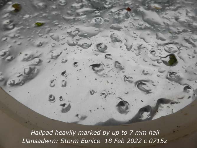
It was back to wintry weather on the 4th with a light covering of snow on the Snowdonia Mountains above 1000 ft including Moel Eilio that had a good white cap. There had been a ground frost of -2.2C and marks of snow pellets were recorded by the hailometer. Precipitation measured at 0900 GMT for the past 24-h was 13.0 mm and the temperature 2.8C, dewpoint 2.2C, RH 96%. Pressure 1009 mb was rising the cold front had reached central England. There was a light WSW'ly wind and the sky was clearing. Fine and cooler day with a maximum of 7.3C at 1327 GMT. A sunny afternoon with solar radiation 6.38 MJ m -2 . On the 5th there was still snow on the Snowdonia Mountains lying at 2000 ft on the northern slopes of the Carneddau and Moel Eilio as low as 1000 ft. At 0900 GMT pressure 1015 mb was falling quickly the weather deteriorating having been bright 6/8th cloud cover at 0830 GMT. Low 973 mb SE Greenland had fronts lying to the NW we were in warm sector air with a warm front Western Isles and N Ireland. A very blustery morning, rain and poor to moderate visibility. Mace Head, Ireland, reported a gust of 58 mph S Uist 54 mph, Aberdaron 48 mph. It was fine and sunny in SE England. A rather wet day [7.7 mm] with a maximum of 9.1C. During the evening a cold front approached arriving here at midnight. The first 15 days were milder than usual the mean temperature 6.8C (+1.1) & [+1.2] of averages, the mean minima averaged 4.3C and was (+1.3) & [+1.5]. Rainfall was 69.1 mm (64%) & [76%] of the monthly mean total. There had been 9 days with ground frosts. It was wet and windy on the 16th with storm Dudley. The Meto had issued a yellow warning for Wales and an amber warning for parts of N England and Scotland. Speed restrictions were in force on the Britannia Bridge early in the day. Storm Eunice heading our way with an amber warning already in force and indications were that it could undergo rapid cyclogenesis. Rare red warnings were subsequently issued for parts of S Wales and SW England bordering the Severn Estuary and N England and Scotland. A pretty rough morning on the 18th with pressure 979 mb falling quickly with low 974 (storm Eunice) near the Fastnet rock. Very windy again on the 23rd with gales especially in the north. Pressure 1016 mb was falling rapidly between complex low 960 mb in the region of S Greenland and Iceland and high 1029 mb Spain we had a strong SW'ly flow There was extremely rough water in the N North Atlantic. The wind was gusting 42 mph with Mona reporting 47 mph and Valley 50 mph. S Uist reported 59 mph, Malin Head 52 mph, Aberdaron 57 mph and Capel Curig 66 mph. There was a shower of rain at 10 GMT, we saw little in the way of sunshine. A cold front passed over close to 2100 GMT with a burst of heavy rain (up to 19.4 mm/h), the temperature dropped and the wind moderated [Rain 7.9 mm, Max 9.5C] (Capel Curig 17.2 mm, Hawarden 11.8C). A quieter cooler day on the 24th with wintry showers and a little snow appearing on the mountains, briefly as low as 1000 ft, that have seen little this season. The wind was W'ly and we were more sheltered, exposed places reporting high gusts included Capel Curig 63 mph, Portland 60 mph, Aberdaron and Tiree 55 mph, Malin Head 49 mph and Mona 43 mph Maximum temperature today 6.8C (Trawsgoed 12.0 mm, Cardiff 8.3C, Aberdaron 6.4h). The 25th began with hardly a cloud in the sky and with the barometer on 1026 mb rising quickly to 1028 mb we had a fine sunny day. A light W'ly breeze and moderate misty visibility at first and hazy (milky) sunshine. There had been a ground frost (-3.2C) and an air minimum of 2.0C the temperature soon rising to 10.5C in bright sunshine 680 W m2 at 1226 GMT. At noon a ridge of high pressure covered the UK from high 1024 mb over Biscay (Milford Haven 12.2C, Aberporth 9.0h). Not a bad day on the 26th though starting mostly cloudy this cleared, but it was breezy the SW'ly force 5. Windier further north with Stornoway reporting a gust of 61 mph compared to Valley 31 mph and here 29 mph. At 0900 GMT pressure 1025 mb was falling with low 950 mb SE Greenland and high 1036 mb over the French and Belgian border. A cold front lay to the NW over Ireland and Scotland [Max 10.8C, Rain nil] (Gogerddan 11.7C, Aberdaron 7.0h, Valley 5.1h). The 27th was a brilliant day though a bit breezy. Beginning with hardly a cloud it was very fine, dry and sunny. Pressure was steady on 1020 mb . High 1040 mb was over the Baltic with deepening low 958 over the Atlantic just W of southern Ireland. This was expected to track north bringing attendant frontal bands our way tomorrow. In the afternoon several spectacular altocumulus lenticularis clouds developed in the vicinity of the weather station. Chinodoxa (The Glory of the Snows) and dwarf white rhododendron are in flower in the garden. Cluster flies are gathering in the Stevenson screen, tempted out of the house roof space by the sunny weather. Finished preparing an old raspberry bed for some new plants [Max 11.7C Grass min -2.7C] (Porthmadog 12.5C Valley 8.8h). As expected the 28th was not a nice day. Pressure was on 1017 mb, but there was a frontal band over the Irish Sea with low 960 mb S of Iceland while pressure was high 1039 mb over E Baltic states. The weather had been deteriorating since dawn, the SSW'ly freshening and visibility was poor in slight rain. The morning was wet with moderate rain at times. The afternoon saw moderate to heavy rain with the temperature falling away from 9.5C from 1300 GMT to 3.7C during the evening as the wind slowly moderated. Sunless [Rain 10.6 mm Max 9.7C Min 5.1C] (Whitechurch 31.6 mm Rhyl 10.9C]. The month ended with a total of 132.9 mm of rainfall (123%) & [147%] of averages, least since 2019 ranking 13th largest in February in Llansadwrn records back to 1928. The mean temperature 6.9C highest since 2019 and the 5th highest in station records since 1979. Sunshine recorded at RAF Valley was 76.1h (91%) & [97%] of averages, lowest since 2017 and ranking 43rd on the Anglesey record since 1931.
March 2022
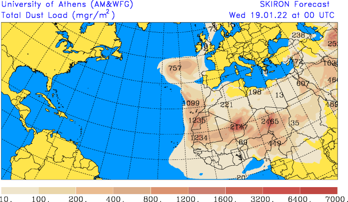
March 1 - the month began with a few of the old fashioned daffodils in flower in the garden in time for St. David's Day. There were plenty of the small narcissi in flower as well and of course there are leeks on the vegetable patch. It was a nice sunny day, at 0900 GMT cloud 6/8th was spilling over the tops of the Carneddau Mountains in an E'ly breeze. The fields were white with frost early the grass minimum reading -3.3C, there was just a little left. There was no air frost recorded. Pressure 1031 mb was rising with a high centred on Belfast 1030 mb, a frontal band was located over SE England and Brittany. The temperature rose to 8.6C and honeybees and a large bumblebee were seen on the heathers in flower on the rockery banks in the garden. (Aberdaron 8.8h Valley 7.7h Porthmadog 10.7C). In contrast the 2nd began overcast and wet remaining so all day. The ground was still saturated so there was some standing water about [Rain 3.9 mm] (Valley 11.1C, but sunless, Cardiff 11.4 mm, Scilly Is. 15.8 mm). Another wet day on the 3rd, overcast sky and calm at 0900 GMT with poor misty visibility. Not a great deal of rain here [1.0 mm], but sufficient for a little standing water on the saturated soil. Slight rain or drizzle most of the day. A glimpse of the sun in the west as it set under the cloud sheet (Llysdinam 16.6 mm, Cardiff 10.7C, no sunshine in Wales with Tibenham having 7.7h). Another calm morning at 0900 GMT on the 4th after an overnight ground frost of -2.5C the sky was becoming cloudier with moderate misty visibility. There was a slow-moving trough over eastern England, but with a ridge of high pressure to the west from Atlantic-high 1031 mb off Iberia pressure here 1023 mb was rising. Taking advantage of a dry day I planted a set of new raspberry canes along the prepared ridged bed [Max 8.3C] (Manston 13.1C Cardiff 12.0C Mona 6.0 mm Valley 3.5h). Cold enough on the 5th for a little snow to fall on the summits of the Snowdonia Mountains particularly on north-facing slopes, Yr Wyddfa and Garnedd Ugain looked quite white in the afternoon sunshine. Pressure 1030 mb was rising with high 1032 mb over Shannon and we had a sunny day. To the east frontal cloud associated with low 987 mb Norwegian Sea lay from the Norwegian coast over SE England to France (Usk 10.9C Trawsgoed -3.8C Valley 10.1h). On the 6th, another fine sunny day with a chilly E'ly breeze. Pressure was steady on 1034 mb within a high centred over central Scotland. The day was cloudy in the south, but sunny in the north. The lawn grasses have been growing steadily (1.4 g dry mass m -2 d -1) through the winter and needed a trim, the standing biomass yield was 0.74 tonnes per hectare. So it was out with the mowers for the first time this year, that started after a bit of coaxing. Soil moisture 2-10 cm depth under grass was 52% dm, the top 2 cm had 97 % dm and the bare met plot 0-10 cm had 36% dm. In sheltered sunny parts of the heather covered rockery banks honeybees were out foraging (Porthmadog 11.3C Kinbrace -7.3C Valley 9.9h). Hardly a cloud in the sky on the morning of the 7th after a clear starlit night and what has now become a rare event, an air frost of -0.9C. The fields and newly trimmed lawns were covered with white frost (mostly dew) with a grass minimum of -4.7C. Sunny with a light ESE'ly breeze and an air temperature of 1.4C (dewpoint -0.5C) rising to 8.7C in the afternoon. Pressure 1027 mb was falling slowly with high 1030 mb over the North Sea. A warm front lay over mid-Atlantic to the north-west. Again we were lucky to have sunny weather in the north whereas in the south it was mostly cloudy. Dry enough in the afternoon to hoe off some weeds on the vegetable plot (Porthmadog 10.3C Mona min -5.1C Valley 9.7h). The 8th began cloudier with moderate to good rather hazy visibility. Pressure 1007 mb was falling quickly with a frontal-wave low 975 mb just off SW Ireland. There was a cold front over the Celtic Sea associated with low 964 mb S Iceland. No air frost, but there was a ground frost -3.0C. Hazy sunshine in the morning disappeared in the afternoon as cloud thickened enough for some non-wetting drizzle at times [Max 12.3C Rain trace] (Valley 4.6h). Continuing mild on the 10th with a slow-moving weakening frontal band over the Irish Sea. At 0900 GMT with pressure on 1011 mb the temperature was 11.5C which rose to 12.5C at 1030 GMT. Dry and pleasantly warm and sunny at first in a S'ly breeze before arrival of a cold front which spoiled things for the afternoon [Rain 0.5 mm] (Hawarden 12.6C Whitechurch 1.6 mm Valley 2.3h). Beginning dull on the 11th with rain in sight on the mountains. At 0900 GMT it was still fine, but soon the slight rain arrived. Pressure 997 mb was falling rapidly. Continued with slight rain and drizzle at times throughout. Snow was absent on the mountains [Max 11.6C Rain 9.4 mm] (Porthmadog 13.7C Libanus 17.8 mm Aberporth 0.4h). A bright start on the 12th with just a few cumulus clouds over the mountains. Pressure 1002 mb was rising and two or three fair-weather clouds developed overhead. It was wintry again on the mountaintops of Snowdonia with a little snow fallen. Pressure was high 1035 mb SE Europe, but low 982 mb over the Celtic Sea deepened to 975 by noon with gales developing later [Max 11.1C Rain 0.2 mm] (Hawarden 13.1C Scolton 20.0 mm Valley 4.6h). A windy day on the 13th starting sunny with 3 oktas cloud cover over the Snowdonia Mountains with some fair-weather cumuli developing at 0920 GMT. Pressure was on 996.5 mb with low 980 mb Shannon with Malin Head reporting a gust of 58 mph, filling to 985 mb at noon. Force 7 at Valley gusting to 53 mph and 48 mph at Gorwel Heights. With the wind S'ly wind reaching gale force in SE Anglesey at times it was too windy to be outside near the tall trees [Max 11.5C Rain 0.5 mm] (Cardiff 12.3C Usk 12.6 mm Valley 6.7h). By the 14th the wind had moderated to force 4 SW'ly at 0900 GMT with the sky mostly clear of clouds. Pressure 1021 mb was rising with lows 1005 mb W Isles and 1003 mb Norwegian Sea losing their identity. West of deep low 931 mb S Greenland pressure was rising in a ridge from the Azores 1032 mb. Moderately sunny with a few clouds developing through the day [Max 10.0C Min 4.0C Grass 0.2C Rain 1.4 mm] (Cardiff 14.0C Capel Curig 7.4 mm Aberporth 10.7h Valley 4.3h). A little snow had fallen overnight on the mountains on the Carneddau, Yr Wyddfa and Garnedd Ugain mostly over 3000 ft. On the 15th the blue flowers of Chinodoxa in the garden (Glory of the Snows) was looking good and there was double drumming from woodpeckers in the woodland. During the day the grass field across the road S of the weather station was sprayed with herbicide. A lot of fields in the area are looking brown having been similarly treated in preparation for sowing spring cereals. More fields this year in the light of changing farming practice, Brexit and the Ukraine War. Herbicide treatment and more cereal growing is a fairly new thing hereabouts, gone are the days of semi-permanent pastures with a little barley grown [Max 12.0C Min 1.6C Grass -2.0C Rain 0.5 mm] (Rhyl 14.2C Gorddinog AWS 13.6C Gorwel 13.3C Aberdaron 9.9C Bala min -3.2C Capel Curig 0.8 mm St Athan 1.5h). The first 15 days were close to the March mean temperature 7.1C [(+0.1)] of averages, Rainfall was only 20.3 mm (22%) & [26%] of the monthly mean total. While there had been 8 ground frosts there were no air frosts. The 16th began calm and overcast with light to moderate rain through the morning turning to snow on the mountains later. There was little or no wind all day, frontal cloud and rain over the Irish Sea cleared eastward during the afternoon with some glimpses of sunshine later. A cold front passed over from 1650 GMT with the temperature falling from 7.9C to 1.9C by evening. Clear sky with a bright moon before cloud encroached again the temperature rising and WSW'ly wind strengthening [Max 7.9C Min 7.0C Rain 4.0 mm] (Hawarden 12.2C Capel Curig 7.8C Usk 7.0 mm Aberdaron 2.5h). A mostly cloudy morning on the 17th with precipitation in sight on the mountains at 0900 GMT in moderate to good visibility, there was a slight shower of rain at the weather station at 0920 GMT. pressure was steady on 1028 mb in a ridge to SW UK from Azores high 1035 mb. There were cold fronts over the North Sea, NW France and over the Atlantic to the NW associated with low 978 mb S Iceland. Pressure was high 1044 mb over the Gulf of Finland. Spits and spots of rain with glimpses of sunshine through the day with the sky clearing in the evening with a bright moon later [Max 11.4C Min 1.9C Grass -1.5C Rain 0.3 mm] (Cardiff 13.7C Sennybridge -2.3C Capel Curig 3.8 mm Aberdaron 5.8h). With the sky more or less clear overnight and early on the 18th the temperature at 0900 GMT was 7.8C with an air minimum of 6.3C there had been a touch of ground frost -0.6C with heavy dew. Pressure 1042 mb was rising and it was calm with good, but hazy visibility. It was a sunny day the temperature rising to 16.9C here and 16.6C at Gorwel Heights, Llanfairfechan. Bees were on the garden heathers, a peacock butterfly was spotted and buds were breaking on the damson tree and snowberry [Max 16.9C Min 3.4C Rain nil] (Gogerddan 17.0C Mona -0.8C Valley 11.2h). It was sunny almost everywhere on the 19th, not a cloud to be seen at 0900 GMT. Mild for March 13.1C after a frost-free night. Very fine, but very windy the E'ly force 5/6, very good visibility, but perhaps that will change as there is heavy dust over Europe from the Sahara desert [Max 16.0C Min 6.4C Rain nil] (Valley 18.0C and 11.3h). It was great to hear the first chiffchaff of the season arrive at 0940 GMT on the 20th as I completed the morning's observations. Six days earlier than the median date of arrival here, equal earliest with 2012, and 10 days earlier than last year. Fritillaries are also coming into flower in the garden's damp meadow area and dwarf willow buds were breaking on the rockery. Fine, sunny and dry. The soil surface was dry this morning [Max 14.3C Min 3.4C Rain nil] (Porthmadog 14.9C Aberdaron 11.4h Valley 11.2h). Disappointingly overcast and dull on the 21st with good visibility and moderate pollution haze. The cloud was thick enough to produce some spots of dusty rain during the morning [Max 15.6C Min 3.0C Grass -1.2C Rain trace] (Gogerddan 17.3C Bala -3.1C Porthmadog 0.6 mm St Athan 3.8h). On the 22nd another dull morning, but the chiffchaff was singing. Visibility was moderate to good with moderate haze enhanced by Saharan dust a trace of which was detected. From noon it was brighter and in a 12 mph SE'ly Föhn breeze the temperature rose to 19.6C at 1507 GMT the highest of the month, the relative humidity falling to 50%. Gorwel Heights reached 19.8C [Max 19.6C Min 8.9C Rain nil] (Porthmadog 20.7C UK hi, Hawarden 2.6C Aberdaron 10.8h Valley 8.9h). Very fine and sunny on the 23rd with not a cloud in the sky at 0900 GMT. Pressure was on 1030 mb with high 1037 mb S Norway. There was a moderate amount of dust in the air over the UK, visibility here was good with a light haze [Max 18.1C Min 6.8C Rain nil] (Cardiff 18.8C Sennybridge -1.5C Aberdaron 11.2h Valley 10.9h). The 24th began overcast and calm with moderate visibility due to pollution 'smoke' haze. From noon there was a light E or NE'ly breeze and the sky cleared after 14 GMT [Max 17.8C Min 8.1C Rain nil] ( Usk 19.7C Sennybridge 1.7C Aberporth 9.6h). Fine and dry again on the morning of the 25th with moderate smoke haze persisting. Mostly cloudy at first, but breaks appearing with crepuscular rays. The afternoon was sunny and warm with bumblebees and honey bees on flowering plants and heathers in the garden. Small tortoiseshell, peacock and speckled wood butterflies were seen. Red squirrels were seen in the trees and feeding boxes, there are five or six different ones visiting at present distinguished by size and colour of their fur. Here the temperature reached 18.6C with 43% RH and 18.9C with 29% RH at Gorwel Heights while Gorddinog AWS recorded 19.6C with 32% RH [Max 18.6C Min 7.9C Rain nil] (Gogerddan 18.7C Sennybridge -1.6C St Athan 9.9h). On the 26th again little in the way of clouds with a light N'ly breeze. Haze was thick today with moderate visibility. There are flowers on plum and damson while buds on apple were breaking. The Gadlys 'old cricket field' was lightly ploughed today after previous herbicide treatment [Max 17.7C Min 7.7C Rain nil] (Porthmadog 20.5C Bala -1.7C Aberdaron 11.3h Valley 11.0h). Very fine and sunny on the 27th with very good, but hazy visibility, there was an inversion looking across to the mountains. Pressure was steady on 1033 mb with high 1035 mb over the North Sea. No frosty overnight but there was moderate dew on the grass with a minimum of 1.5C. There were no clouds and the sea was calm at Rhosneigr where several were in enjoying the water [Max 17.7C Min 5.7C Rain nil] (Porthmadog 18.8C Bala 0.8C Aberdaron 12.0h). A mostly cloudy beginning to the 28th with pressure 1024 mb falling as a ridge from high 1031 mb N Adriatic to Scotland declining. Visibility was poor to moderate with thick haze enhanced by Saharan dust. The patch of cloud overhead soon began to clear and the rest of the day was sunny [Max 16.3C Min 8.9C Rain nil] (Scolton 17.7C Trawsgoed -1.2C Aberdaron 11.5h). Fog had formed overnight on the 29th and though reducing by 0900 GMT fog was moderate with the sky obscured. Pressure had fallen to 1011 mb the high having dissipated and a low 1016 mb was charted over the North Sea. A showery trough had formed over N England. Soon the sun was breaking through and the afternoon was mostly sunny. A cold front over S Scotland at midnight was moving towards N Wales [Max 15.2C Min 5.4C Pptn 2.0 mm] (Porthmadog 18.7C Capel Curig -0.4C St Athan 0.4 mm Valley 8.4h). The 30th began overcast with a burst of heavy rain at 0741 GMT. It was cooler and damp at 0900 GMT and snow had fallen in the north including Newcastle. Sunny spells and slight showers in the afternoon with snow pellets falling in the evening and snow on the Snowdonia Mountains. The first bluebells had appeared in the wood seven days before the median date of recent years. Cold fronts passed over N Wales at noon and 1800 GMT (Milford Haven 13.3C Trawsgoed 0.3 mm Cardiff 7.4 mm Valley 0.7h). In a return to winter there was snow at 1000 ft at Llyn Ogwen on the morning of the 31st and there was a shower of snow pellets and snow here at 06 GMT. Valley reported sleet showers between 0720- 0920 GMT. At 0900 GMT with 5 oktas cumulus cloud cover there was a brisk cold (3.8C) N'ly breeze. Snow was lying on the northern slopes of the Carneddau as low as 450 ft. The clean air from the north had cleared away atmospheric pollutants and dust and visibility was excellent, three fast jet from RAF Valley flew over at 0904 GMT heading SE. Sunny spells in the afternoon then a shower of large 1 cm conical snow pellets fell at 1820 GMT almost covering the ground and there were some snow flakes later [Max 7.2C lowest of month, Min 1.6C Grass -0.6C Pptn 1.0 mm] (Porthmadog 9.1C Trawsgoed -4.0C Bala 2.0 mm St Athan 11.1h Valley 7.6h). The month ended with a total of 29.1 mm of rainfall (32%) & [37%] of averages, least since 1993 ranking 7th lowest in March in Llansadwrn records back to 1928. The mean temperature 8.7C highest since 2012 was equal highest in station records since 1979 ranking 2. Sunshine recorded at RAF Valley was 193.3h was most for 80-years and ranking 2nd on the Anglesey March record since 1931.
April 2022
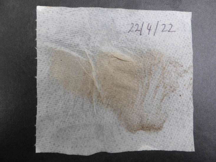
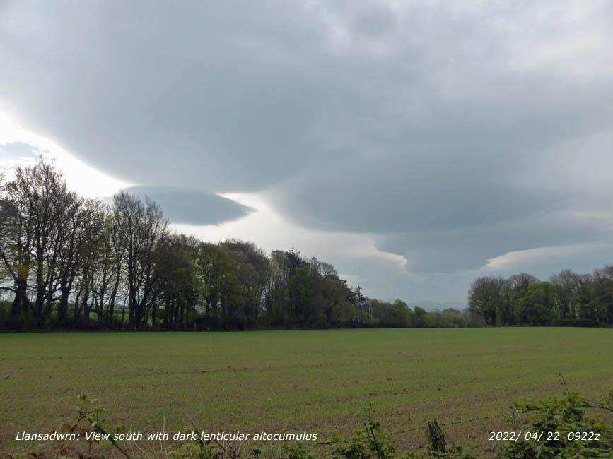
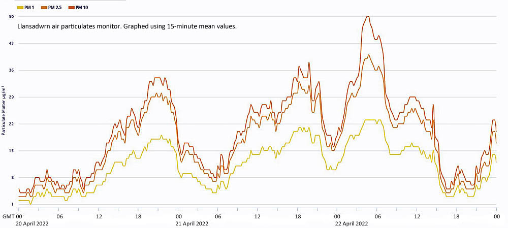
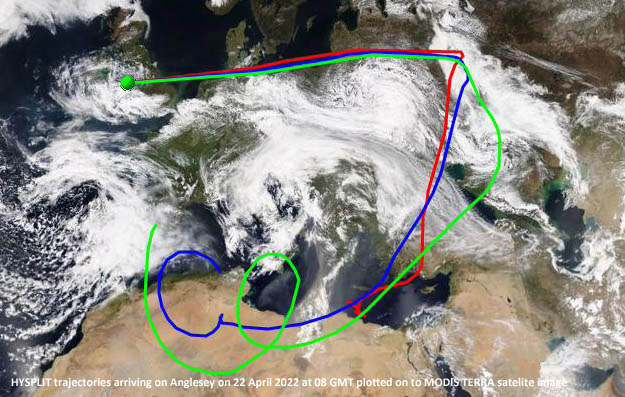
April 1 - began fine and cold with snow on the Snowdonia Mountains. Pressure 1023 mb was rising with high pressure 1028 mb Shannon, low 990 mb was over the Mediterranean. Cumulus clouds and a cumulonimbus were in the vicinity and the visibility was excellent, very clear. Sunny spells through the day with a cool N'ly breeze [Max 8.4C Min 2.4C Rain 3.4 mm] (Cardiff 10.1C Sennybridge -6.7C Llysdinam 1.2 mm Aberdaron 10.8h). . A cloudy calm morning on the 2nd and after earlier rain there was drizzle with poor visibility. By 1030 GMT it was brighter and the afternoon sunny [Max 9.9C Min 2.1C Grass -1.3C Pptn 0.1 mm] (Cardiff 10.8C Sennybridge -6.3C Rhyl 13.2 mm Aberporth 4.9h). A fine and sunny morning on the 3rd, but we still had the cool N'ly air and it was wintry on the mountaintops with a temperature of -3C. There was a white grass frost early with a ground frost of -3.4C and an air minimum of 0.3C. This had risen to 6.1C at 0900 GMT with pressure 1028 mb steady. High 1031 mb was SW of Ireland the high-pressure covering Ireland and Wales. There were a few well-developed cumulus clouds in the vicinity the day keeping mostly sunny and dry until late afternoon when cloud encroached associated with a warm front arriving at midnight [Max 11.1C Min 0.3C Rain 8.0 mm[ (Cardiff 11.7C Sennybridge -7.5C Aberdaron 9.0h). Mild overnight with rain that by 0900 GMT on the 4th had accumulated 8.0 mm. Pressure was steady on 1012 mb with high 1029 mb W of the Bay of Biscay with low 983 mb S Norway. We were in warm sector air the temperature at midnight 7.1C and at 0900 GMT it was 10.1C. Recent slight rain then drizzle had ceased, but it was dull and damp with the day sunless [Max 12.7C Min 6.1C Rain 2.8 mm]. The 5th was similarly dull with a minimum of 8.3C rising to 10.1C at 0900 GMT. Pressure was on 1010 mb, but low 986 mb S Iceland was deepened through the day and was 986 mb at 1800 GMT when a cold front over Shannon at noon had reached the Isle of Man. Some glimpses of sunshine and showers of rain in the afternoon with the WSW'ly wind strengthening during the evening as the cold front passed over Anglesey [Max 10.9C Min 8.3C Rain 3.4 mm] (Hawarden 14.2C Libanus 8.3C Capel Curig 11.2 mm Aberdaron 1.1h). The 6th was dull and wet with a moderate SW'ly wind. Pressure 992 mb was falling quickly with low 975 off the Western Isles. A Meto yellow warning for wind had been issued for NE Anglesey, Coast and Cumbria, the wind strengthening through the day when in the evening gusts of 39 mph were recorded 41 mph at Aberdaron. At 1800 GMT the ,low was 968 mb reaching 970 mb over the North Channel at midnight. (Trawsgoed 13.3C Lake Vyrnwy 5.2C and 17.6 mm Aberdaron 5.9h) [Max 10.7C Min 7.7C Rain 1.8 mm]. Strong winds continued on the 7th gale force with strong gusts 54 mph at Valley reported at 0150 GMT with 45 mph here. Pressure dropped here to 979 mb at 0220 GMT on the 7th before starting to rise. There was a burst of heavy rain at 0522 GMT and pressure at 0900 GMT 985 mb was rising quickly the low having crossed S Scotland to the N Sea 970 mb . The Meto yellow warning was in operation and Aberdaron reported a gust of 58 mph. A blustery morning with temperatures somewhat below those expected for the time of year. At 1255 GMT there was a shower of snow pellets then sleet. Snow had fallen on the Snowdonia Mountains and was lying at 2500 ft (Cardiff 13.5C Lake Vyrnwy 3.3C Capel Curig 16.2 mm St Athan 8.4h) [Max 9.6C Min 5.7C Pptn 1.7 mm. Pressure 1001 mb was still rising on the 8th after a cold night with white frost on the grass early. Fine with sunny spells and cold 6.3C at 0900 GMT. There was a NNE'ly breeze and cumulus clouds were developing, a few were towering. Visibility was very good with clear Arctic air reaching here from the Barents Sea [Max 10.1C Min 0.5C Grass -3.6C Pptn 0.3 mm]. The first 15 days had rainfall of 30.8 mm (60%) & [47%] of the monthly mean averages. After a wintry start there had been 6 ground frosts there were no air frosts the lowest 0.1C. The mean temperature 8.5C was (-0.5] & [-0.7] of averages. The 16th began fine and bright 6 oktas cloud cover with very good visibility and a temperature of 13.2C. Pressure was steady on 1028 mb with a high 1038 mb over S Norway. Low 985 mb was situated SE Greenland and remnant frontal cloud over the Irish Sea was burning off as a light SW'ly breeze picked up after 0930 GMT. The temperature rose to 17.9C in the middle of the afternoon, orange tip butterflies were seen (Cardiff 21.2C Bala 3.7C Nosig rain St Athan 9.0h) [Max 17.9C Min 9.0C Rain nil]. Another fine morning 6 oktas mainly cirrus clouds on the 17th with a light ENE'ly breeze developing after calm blackcap and chiffchaff were singing. Visibility was good with a slight smoke haze With pressure steady on 1020 mb frontal cloud was to the west over Ireland with a band of rain sliding northwards a little eventually reaching here early in the evening. Not before the temperature had risen to 19.7C, highest of the month (Gogerddan 19.7C Usk 3.8C Whitechurch 2.4 mm Aberdaron 5.9h) [Max 19.7C Min 8.6C Rain 0.4 mm]. A fine and dry though mostly cloudy morning on the 18th with light SW'ly wind. Bright with good visibility. Pressure 1017 mb was rising with low 998 mb between Scotland and Ireland moving to N Scotland by noon A cold front was over E Britain with a detached occluded front over the Celtic Sea. Sunny by afternoon (Usk 15.2C Libanus 3.4C Swyddfynnon 7.4 mm Aberdaron 11.4h) [Max 13.9C Min 7.1C Rain nil]. The 19th began with developing cumulus clouds and steady pressure 1020 mb. The air felt cool 9.8C at 0900 GMT, the cumuli did not pose a threat and the afternoon was sunny (Usk 16.1C Bala -0.8C Swyddffynnon 5.8 mm Valley 12.9h) [Max 12.8C Min 4.6C Grass 1.5C Rain nil]. The sky was clear of cloud on the 20th and visibility was very good, fine and sunny though still feeling cool in a light N'ly breeze. The Hubble telescope 32-years old today has brought us some amazing images of the galaxies. The new Webb telescope's instruments are still being set up and have been cooling down to a working temperature of 7 Kelvins by a 'gaseous helium cryocooler'.The large mirror made of beryllium coated with gold is still cooling to a working temperature, but has been successfully aligned and receiving sharp images. Visibility here on Earth in Anglesey deteriorated during the afternoon with atmospheric particulates increasing (Porthmadog 19.2C Bala -0.3C St Athan 1.0 mm Aberdaron 13.2h) [Max 17.3C Min 3.8C Grass 0.6 mm Rain nil]. Cloud was increasing on the morning of the 21st with good visibility, slightly hazy. Pressure 1014 mb was steady in a ridge from high 1031 mb over the Norwegian Sea. A low off SW Ireland had an associated rain-bearing frontal band. A cool ENE'ly breeze was picking up with some mostly weak sunshine. Dust from the Sahara was over the North Sea moving west and a trace of coloured dust was collected here at 0900 GMT (Porthmadog 19.9C Usk 3.1C Nosig Rain Aberdaron 10.5h Valley 2.5h) [Max 15.6C Min 8.0C Rain trace). #The 22nd began mostly cloudy with poor visibility in moderate haze. To the south there was a band of fairly low dark lenticular altocumulus clouds (below right). The 0600 GMT MetO chart showed a low 994 mb over Biscay off Cap Finisterre with highs 1038 mb Norwegian Sea and 1022 mb over the Black Sea this resulting in a flow of air from the east. The 23rd was a fine sunny day though somewhat breezy. Pressure was on 1009 mb with high 1034 mb over the Norwegian Sea and low 991 mb over Biscay. There was an easterly airflow. A drying wind the soil surface was dry with small cracks in the undisturbed met plot. Planted a row of potatoes and peas (Porthmadog 18.2C Sennybridge 3.3C Nosig rain Aberdaron 7.5h) [Max 15.7C Min 6.7C Grass 4.1C Rain nil]. Another sunny day on the 24th with pressure 1013 mb rising, there was a moderate to fresh NE'ly wind with strong winds across the the tops of the Pennines. Dry here, but there were showers in Cornwall (Whitechurch 19.2C Bala 3.2C Nosig rain Aberdaron 13.5 h) [Max 15.2C Min 7.3C Grass 3.6C Rain nil]. Hardly a cloud in the sky on the morning of the 25th with pressure 1018 mb still rising. Highs 1038 mb Greenland/ Iceland region and low 998 mb over the Atlantic off Cap Finisterre giving an easterly airflow, lighter breezes today, but cooler (Porthmadog 16.2C Hawarden 1.7C Nosig rain Valley 13.5h) [Max 12.6C Min 5.7C Grass 2.7C Rain nil]. Again on the 26th not much in the way of clouds at first, but cumuli were showing signs of development over mountains to the south. Pressure keeping high on 1023 mb in a ridge from high 1033 mb Norwegian Sea. The MetO charts showed we were surround by low pressure areas. Potted up seedling Tumbler and Tumbler Bella outdoor bush tomato plants into larger pots, the latter a new variety that has taken 15y to develop. Tumbler was badly affected by blight last summer for the first time, it's hope Bella will be more resistant. Very fine and sunny (Cardiff 17.5C Bala -0.6C Nosig Rain Aberdaron 13.6h Valley 8.9h) [Max 15.2C Min 4.9C Grass 1.9C Rain nil]. A bit cloudier on the morning of the 27th with 5 oktas cover of altocumulus, cumulus and cirrus clouds, but pressure 1029 mb was still rising. High pressure 1032 mb was centred near Wick, Scotland. Very fine with hazy sunshine. Strimming long grass (non meadow areas) was the gardening job for today, dismayed to see so much lesser celandine in flower that had increased from very rare to abundant even dominant in places in the garden and along roadsides hereabouts. It dies back early, but can smother short grasses and kill them off and compete with ivy as well. Trying to keep it out of the old woodland where bluebells are a feature (Porthmadog 15.6C Capel Curig 1.0C Nosig Rain Aberdaron 6.8h [Valley 7.8h]) [Max 13.1C Min 5.3C Grass 2.2C Rain nil]. pressure was high 1035 mb at 0900 GMT on the 28th across much of northern UK, here steady on 1034 mb. Cloudier mainly altostratus with moderate haze including Saharan dust, but none was deposited at ground level. A mostly grey, but dry day [Max 11.5C Min 3.8C Grass 1.5C Rain nil]. . Fine and sunny though the sky was covered with 6 oktas cirrus clouds with 1 okta of cumulus on the 29th. Visibility was moderate with haze (Porthmadog 15.9C Sennybridge -3.0C Nosig Rain St Athan 8.9h [Valley 11.7h]) [Max 13.8C Min 3.9C Grass 1.3C Rain nil]. A mostly cloudy morning on the 30th with moderate haze and some hazy sunshine at first (none bright). Pressure was on 1031 mb in Wales high 1032 mb, frontal bands associated with low 1013 mb were lying off NW Scotland with a warm front over NW Ireland. A change in the weather with a SW'ly instead of E'ly winds. Later in the afternoon there were spits and spots of rain with low 1014 mb off the Western Isles at 1800 GMT the warm front with rain then over the Irish Sea and western Scotland (Cardiff 17.0c Sennybridge -3.2C Valley 5.2 mm St Athan 5.4h) [Max 13.1C Min 5.1C Grass 2.6C Rain 5.0 mm]. ..
The month ended with a total of 36.2 mm of rainfall (71%) & [55%] of averages, most since 2019 ranking 20th lowest in April in Llansadwrn records back to 1928. The mean temperature 9.5C highest since 2020 ranked 16th in station records since 1979. Sunshine recorded at RAF Valley was 179.9h (provisional) was lowest since 2019 and ranking 24th on the Anglesey record since 1931.
May 2022
May 1 - began on a rather dull note with slight to moderate rain. It was one of those days that Anglesey remained enveloped in low cloud all day with light rain and/ or drizzle. After the fine weather we have had it was unpleasant, but the garden needed the rain as it had become very dry and would save me watering. Sunless here, in contrast Llanfairfechan was dry with some sunshine (Hawarden 14.8C Sennybridge 5.1C Porthmadog 17.8 mm Aberporth 0.1h) [Max 10.7C Min 8.2C Rain 4.2 mm]. Overcast and dull on the 2nd with moderately high altostratus and cumulus clouds. Kept mostly dry with concrete drying by 10 GMT. Pressure steady on 1023 mb with high 1039 mb Azores and low 988 mb N Sweden. Brighter with a little sunshine later (Usk 16.3C Mona 4.1C Sennybridge 0.4 mm Aberdaron 2.1h Valley 0.0h) [Max 14.2C Min 6.3C Grass 4.0C Pptn trace]. There was fog at 0630 GMT on the 3rd visibility increasing, but still very poor at 0900 GMT. Overcast and calm at first, brightening later with glimpses of sunshine in the afternoon (Capel Curig 16.7C Bodelwyddan 7.5C Libanus 9.6 mm (wettest) Aberdaron 3.3h) [Max 15.9C Min 9.2C Rain 5.3 mm]. Again beginning overcast and dull on the 4th with moderate to good visibility the cloud sheet low on the mountaintops of Snowdonia. Pressure 1018 mb was rising with Atlantic-high 1026 mb W of Iberia having a ridge to SW Britain. An occluded front lay over the Irish Sea with low 995 mb Norwegian Sea. The cloud slowly lifted and there were some sunny spells in the afternoon (Usk 19.1C Libanus 5.8C Bodelwyddan 8.4 mm Aberdaron 8.8h (sunniest)) [Max 14.8C Min 10.5C Pptn trace]. Mostly cloudy on the morning of the 5th, but it was breaking with some weak hazy sunshine with some bright sunshine later. The bluebells in the wood are still looking good with some fading a little as the canopy closes over. Feeling warmer in warm sector air Atlantic-high 1028 mb off Cap Finisterre having a ridge to S Britain (Usk 20.6C Sennybridge 2.3C Nosig Pptn Bala 9.6h) [Max 17.8C Min 8.8C Rain nil]. Dull and breezy on the 6th, but visibility though hazy was good with pressure steady on 1024 mb. Bands of rain were affecting Ireland and Scotland slowly sliding eastward on a weakening cold front in high pressure 1029 mb centred over the Celtic Sea and 1026 mb NW Scotland. Slight showery rain arrived during the afternoon after a little sunshine (Usk 16.4C Libanus 5.8C Trawsgoed 9.2 mm Hawarden 1.9h Valley 0.2h) [Max 13.6C Min 10.6C rain 3.9 mm]. The 7th began much brighter with improving visibility. Pressure 1029 mb was rising again with sunny spells developing in the morning and a sunny afternoon (Usk 21.6C Sennybridge 4.1C Hawarden 0.8 mm Valley 11.2h) [Max 16.4C Min 8.9C Rain nil]. A fine sunny and warm day on the 8th (Cardiff 20.8C (highest) Whitechurch 5.4C and 0.21 mm Aberdaron 12.7h Valley 10.2h) [Max 20.2C Min 8.9C Rain nil]. The 9th began overcast with a moderate SW'ly wind. Pressure 1020 mb was falling with a complex Atlantic-low W983 mb of Scotland , pressure was high 1034 mb over the Baltic. Rain was brushing western parts of Anglesey, but here cloud was thin enough for some weak sunshine and occasional glimpses of bright sunshine. The afternoon was windy with showery rain from 15 GMT, heavy around 18 GMT, leading on to a blustery evening and night (Cardiff 21.5C Bala 4.3C Capel Curig 7.8 mm Hawarden 0.7h Valley 0.0h) [Max 15.3C Min 9.4C rain 9.2 mm]. A cold front had passed over Anglesey early on the 10th and the sky was clearing at 0900 GMT. Bright and breezy the SW'ly strengthening through the day that became mostly sunny (Hawarden 18.4C Libanus 8.6C Capel Curig 5.6 mm Valley 10.4h) [Max 15.7C Min 9.8C Rain 4.6 mm]. Windy overnight with pressure falling to 1005 mb at 0738 GMT on the 11th. The wind had moderated by 0900 GMT when it was mostly cloudy with the Snowdonia summits covered. The morning brightened being on the north-west edge of a band of moderate to heavy rain over Wales and SW England. Having the best of the weather the afternoon was dry with sunny spells (Usk 17.4C Lake Vyrnwy 7.9C Gogerddan 22.6 mm Valley 8.9h) [Max 164C Min 9.9C Rain nil]. A fine dry day on the 12th with good visibility. Pressure 1018 mb was rising with low-pressure 986 mb Iceland and Norwegian S and high-pressure 1025 mb over N Africa. There was a cold front over the Baltic and central France (Cardiff 16.9C Sennybridge 3.1C Cardiff 0.8 mm St Athan 9.6h) [Max 14.5C Min 6.9C Rain nil]. Fine and sunny on the 13th with a very gusty SW'ly wind (Hawarden 17.6C Tredegar 8.1C Cardiff 0.4 mm Aberdaron 12.1h Valley 11.9h) [Max 15.9C Min 10.1C Rain nil]. The fine and dry spell continuing on the 14th with pressure steady on 1021 mb. High-pressure 1023 mb over Belgium extended to southern Britain. A low SW of Iceland 992 mb had a warm front over N Scotland. A complex sky with cirrus, cumulus and altocumulus clouds of 5 oktas was clearing leading to a sunny warmer day with less wind than of late (Llysdinam 21.5C Usk 5.3C Nosig Pptn Hawarden 11.5h Valley 9.4h) [Max 17.7C Min 9.1C rain nil]. Very fine sunny and warm on the 15th with very good visibility. There were cumulus clouds around with showers in places; cumulonimbus were reported in S England and The Midlands. The temperature rose to 20.8C at 1249 GMT, highest of the month. Showery rain from 22 GMT, moderate to heavy 12 mm/h at 2334 GMT (Porthmadog 22.8C (highest) Capel Curig 7.5C Tredegar 11.2 mm Aberporth 7.0h [Max 20.8C Min 9.8C Rain 8.8 mm Valley 22.2 mm]. The first 15 days had rainfall of 36.0 mm (49%) & [55%] of the monthly mean averages. The mean temperature 12.6C was (+0.9] & [+0.8] of averages and it was frost-free. The 16th began dull and damp, but the 14.4C at 0900 GMT felt warm. Visibility was moderate and misty. Pressure 1010 mb was rising with low 986 mb W of Ireland with frontal bands to the W and over the Celtic Sea. Pressure was high over the Med. The afternoon was bright at times with one or two glimpses of sunshine with a short sharp shower at 1625 GMT (Hawarden 22.3C Tredegar 11.2C Aberdaron 20.0 mm Hawarden 3.8h [Valley 2.3h]) [Max 18.4C Min 12.8C Rain 1.2 mm]. Continuing warm and dry, but dull on the 17th with moderate visibility. There was a SSE'ly breeze at 0900 GMT the temperature 16.0C risen from a minimum of 12.8C at 0327 GMT. Low 970 mb was W of Shannon with an occluded front over the Irish Sea and Biscay, pressure here was steady on 1014 mb. There was some sunshine around noon with pressure then falling reaching 1009 mb at 1611 GMT. There was rain from 1430 GMT turning heavy at 1625 GMT (up to 22 mm/h). Pressure rose during the evening reaching 1013 mb at midnight (Bodelwyddan 21.3C Lake Vyrnwy 8.7C Milford Haven 14.2 mm St Athan 4.5h) [Max 20.2C Min 12.8C Rain 7.7 mm]. A promising morning on the 18th with a covering of cirrus, contra and a few fair weather cumuli overhead. It was cooler, but fine and sunny with pressure 1017 mb still rising. There was a moderate breeze that strengthened during the evening with two dry cold troughs passing over at 18 GMT and midnight (Hawarden 20.6C Sennybridge 7.7C Tredegar 8.6 mm Valley 9.7h) [Max 18.2C Min 10.9C Rain 0.8 mm]. The 19th was cooler, but fine and sunny with the sky with cumulus and cirrus clouds clearing. Visibility was good. Soil moisture under grass measured today was 48.9% dry mass while on the undisturbed unvegetated met plot it was 26.0% dm (Hawarden 20.0C Mona 6.1C Scolton 0.4 mm Valley 10.1h) [Max 16.4C Min 8.3C Rain trace]. In contrast the 20th was overcast with the cloud low on the Snowdonia Mountains. It was breezy with a force 4 SSW'ly and there were a few spots of rain just before 0900 GMT. The sun broke through for a while around noon, but the afternoon was dull with strengthening wind and showers of rain, a heavy burst at 1446 GMT falling at a rate of up to 15.8 mm/h (Hawarden 19.4C Sennybridge 7.1C Capel Curig 5.4 mm St Athan 4.9h) [Max 16.4C Min 10.9C Rain 1.5 mm]. Pressure was steady on 1020 mb on Saturday the 21st with pressure high 1025 mb over N France, but low 1005 mb was west of Shannon. Fine, cool and breezy (SW'ly force 3) at 0900 GMT with bright or sunny spells developing. We had the family including children here in the garden for a rare visit, due to Covid rules, keeping seniors safe. At 3 pm we were unfortunately sprayed by the local farmer when he was spraying an adjacent field of cereals imparting a chemical smell and the making our eyes smart. We were given no warning of this and the wind speed was 20 km/ h force 4 off the field onto our house and garden above the advised wind speed for crop spraying... (Cardiff 19.0C Hawarden 6.1C Nosig Capel Curig 0.2 mm Bala 7.0H Valley 6.5h) [Max 16.3 C Min 8.5C Rain 0.4 mm]. Overcast skies and very poor visibility on the morning of the 22nd with slight rain and drizzle. Dull and wet here most of the day while it was fine and sunny in SE England and Newcastle. It cleared up a little about 14 GMT when brighter with glimpses of sunshine (Cardiff 21.8C Tredegar 7.2C Capel Curig 12.0 mm Valley 4.5h) [Max 14.6C Min 12.1C Rain 3.2 mm]. Another dull morning on the 23rd with a light WNW'ly wind. Pressure 1003 mb continued to fall with low 995 mb over the Norwegian Sea and low 1002 mb over Belgium. There was an occlusion over S central Britain. At 0900 GMT rain was in sight and we had a little within 10 minutes. Further sprinkles during the morning then it cleared up fine in the afternoon (Cardiff 16.2C Libanus 7.8C Trawsgoed 3.6 mm Aberdaron 3.8h) [Max 15.4C Min 10.3C rain 0.2 mm]. On the 24th pressure 1006 mb was rising with a force 3 WSW'ly breeze. Dull all morning with sprinkles of rain then brighter with sunny spells in the afternoon (Usk 17.2C Lake Vyrnwy 6.3C Libanus 2.6 mm St Athan 10.0h) Max 15.6C Min 8.6C Rain 1.8 mm]. A misty morning on the 25th began dull and breezy. Pressure 1007 mb was rising with low 987 mb SW Ireland. An upper level trough of cooler air from the Arctic over Scotland was reaching southwards to Spain. The sun broke through by the afternoon (Hawarden 18.0C Tredegar 6.3C Capel Curig 13.2 mm Valley 8.2h) [Max 16.6C Min 10.4C Grass 8.5C Pptn 0.1 mm]. Another dull and misty morning on the 26th with drizzle on the wind at 0900 GMT. There was a complex of lows 990 mb to the N, but pressure here 1017 mb was rising with high-pressure to the south. A cloud mass was over the UK in warm sector air. Stornoway reported small hail showers with heavy marine showers over the Atlantic to the west. The morning continued damp before showers and sunny spells arrived for the afternoon (heaviest 6.6 mm/h at 1249 GMT) (Hawarden 18.9C Sennybridge 8.5C .Lake Vyrnwy 6.8 mm Valley 4.6h) [Max 15.9C Min 10.2C Grass 6.2C Pptn 2.8 mm]. A brighter morning on the 27th after a cooler night air minimum 6.9C Grass 2.2C with heavy dew. Pressure 1027 mb still rising with high 1030 mb over the Celtic Sea. Fine with sunny spells and feeling warmer in the WSW'ly breeze. At Tywyn Aberffraw saw early purple and twayblade orchids in flower (Cardiff 20.1C Scolton CP 5.9C Cardiff 1.8 mm St Athan 14.3h) [Max 16.2C Min 6.9C Grass 2.2C Rain nil]. Fine and sunny with a cool N'ly breeze on the 28th with pressure on 1029 mb with high 1031 mb lying between Scotland and Iceland (Mumbles Head 19.7C Swyddffynnon 1.4C Nosig Pptn St Athan 13.5h Valley 12.9h) [Max 15.6C Min 11.2C Grass 4.8C Pptn trace].. Overnight on the 29th the sky was clear with no moon with bright stars shining (Anglesey Dark Skies). Thick low level fog had formed by 0645 GMT with the sky still clear. The minimum was 6.0C, lowest of the month, Cloud then formed and there was a slight shower of rain just before 0900 GMT in poor visibility. Pressure was on 1022 mb with the high 1032 mb now between Iceland and Scotland a ridge over Britain in decline. The cooler day turned sunny by afternoon. The electricity flashed off early in the afternoon, no thunder was heard, but near Llanbedr in Gwynedd 3 Welsh Black Cattle were killed by lightning, others animals sheltering under the same tree escaped this fate (Scolton CP 16.8C Sennybridge 1.2C (lowest) Swyddffynnon 7.6 mm (most) Aberdaron 14.1h (most) Valley 11.8h) [Max 14.4C Min 6.0C Rain 2.6 mm]. A mostly cloudy day on the 30th beginning with showery rain. Cool the temperature at 0900 GMT 9.4C with the grass minimum down overnight to 4.5C. Pressure 1013 mb was falling with a detached occlusion over the North Channel with lows 1008 mb N Sea and 995 mb over the Atlantic W of Iberia. Mostly dull, little in the way of sunshine and the maximum 11.6C was the second lowest of the month (Cardiff 17.7C (highest) Bala 1.9C Swyddffynnon 5.6 mm St Athan 6.8h Valley 0.6h) [Max 11.6C Min 6.1C Grass 4.5C Rain 5.2 mm]. The 31st began showery one falling at 27 m/h at 0550 GMT. At 0900 GMT there were towering cumuli in the vicinity and cumulonimbus were reported, visibility was moderate with mist. Variable winds mostly cloudy around noon, but sunny spells before and after (Cardiff 17.9C Libanus 4.1C Bala 8.4 mm St Athan 10.7h Valley 6.0h) [Max 1.8C Min 7.2C rain 3.0 mm].
The month ended with a total of 66.5 mm of rainfall (91%) & [98%] of averages, most since 2020 ranking 39 in Llansadwrn records back to 1928. The mean temperature 12.7C highest since 2020 ranked 8th in station records since 1979. A sunny month with 187.3h (provisional)sunshine recorded at RAF Valley (84%) &[93%] of averages.
June 2022
June 1 - after a calm night it was a fine and sunny morning with a light NE'ly breeze picking up. There were cumulus clouds over the mountains particularly central Snowdonia and the west. Pressure 1018 mb was rising with a high 1022 mb W of Ireland. It was a sunny afternoon and I planted out a row of peas on the vegetable plot raised in small pots in the greenhouse frame (wood mice excluded) as the first row had mostly appeared eaten by leaf cutting insects, slugs and/ or and mice. Usually the plants can grow sufficiently fast to be unaffected, but this year not so. Hoping that the larger pot grown plants (50 x 3¨ pots with 3 seeds) will survive the onslaught. This is economical with seed as a sown row would have twice the number of seeds sown with less success. Sowed a batch of runner beans in the greenhouse in the mouse secure frame, same story (Cardiff 18.9C Libanus 6.5C Rhyl 10.0 mm Aberdaron 13.8h) [Max 16.8C Min 8.7C Rain nil]. On the morning of the 2nd at 0900 GMT it was feeling pleasant in the sunshine. I have seen song thrushes about the garden, more evident today with some fledglings seen, they are usually successful here. It was dry here although valley reported rain earlier (Cardiff 21.1C Bala 1.6C Rhyl 2.6 mm St Athan 13.8h) [Max 17.6 Min 7.2C Rain 1.2 mm]. There was a patch of blue sky 'enough to patch a sailor's trousers' over the weather station on the 3rd at 0900 GMT. Visibility had improved a little, was poor now a misty good, in slight rain. Pressure was steady on 1019 mb with high 1026 mb between Iceland and Scotland with a disturbance in upper layers of air and thundery lows 1012 mb over Biscay and 1007 mb Iberian coast. By 1030 GMT it was brighter with glimpses of sunshine and more blue sky and humid. It was fine, but a mostly dull day on the 6th starting with overcast skies and a few low cumulus clouds in the west. Pressure was on 1015 mb with low 1004 mb S North Sea while pressure was high 1020 mb over France, A little sunshine in the afternoon (Tindrum 22.0C Cardiff 21.3C Lake Vyrnwy 8.1C St Athan 3.4 mm & 2.2h) [Max 15.7C Min 9.5C Rain nil]. Fine and sunny on the 7th with good visibility. Pressure was on 1016 mb with high 1021 Norwegian Sea and low SE North Sea. Rain fell just before midnight. Ex-tropical storm Alex was over the Atlantic heading our way (Hawarden 21.6C Swyddffynnon 3.5C Capel Curig 2.0 mm Valley 9.0h) [Max 20.0C Min 9.6C rain 3.6 mm]. A damp morning on the 8th after overnight rain. Pressure 1002 mb was rising with a low 993 mb just off NW Ireland and 983 mb S Greenland. Sunny spells and the odd light shower of rain in the afternoon (Hawarden 19.3C Lake Vyrnwy 10.8C Capel Curig 11.4 mm Aberdaron / Valley 10.2h (highest)) [Max 16.5C Min 12.4C Rain 0.3 mm]. Showers of rain early on the 9th and dull and breezy, poor visibility. Pressure was on 1013 mb with low 977 mb W of Ireland, the jetstream was strong over SW UK with ex-tropical storm Alex. Some sunshine, but strong gusty SW'ly wind (Gogerddan 19.3C Bala 6.7C Whitechurch 5.4 mm (highest) Valley 4.8h) [Max 17.3C Min 9.8C Rain 0.1 mm]. Strong gusty SW'ly winds continued on the 10th with rain insight at 0900 GMT. We were in a plume of warm air from N Africa the temperature 15.8C dewpoint 12.9C. Cumulus clouds were increasing when 6 oktas cover, sunny spells with strong gusts of wind 39 mph too risky to be in the garden near the tall trees (Hawarden 21.1C Llysdinam 10.4C Lake Vyrnwy 1.0 mm Aberdaron 14.2h) [Max 16.8C Min 12.2C Rain nil]. Strong and gusty SW'ly wind again on the 11th with pressure 1017 mb rising. Low 982 mb was between Scotland and Iceland with an occluded front lying over Wales and N England. Bright with glimpses of sunshine the wind moderating late in the afternoon (Heathrow 23.8C Cardiff 19.8C Lake Vyrnwy 10.2C Libanus 3.8 mm St Athan 11.9h Valley 7.6h) [Max 16.8C Min 12.2C Rain nil]. By the 12th pressure had risen to 1024 mb with low ex-Alex mid Norwegian Sea. There was a ridge of high-pressure to the Celtic Sea from high 1033 mb N of Azores. Feeling warm, but breezy, some sunny spell cloudier by late afternoon with a slight shower of rain in the evening (Cardiff 19.3C Lake Vyrnwy 9.2C Whitechurch 0.2 mm St Athan 12.9h) [Max 16.6C Min 10.0C Rain trace].... The first 15 days had rainfall of only 13.9 mm (17%) & [19%] of the monthly total averages. On the cool side the mean temperature 13.5C was (-1.0] & [-0.6] of averages with the highest maximum 20.0C on the 7th. The 16th turned warmer and it was very fine the temperature at 0900 GMT 18.7C. High 1023 mb was over Brittany, pressure here 1020 mb had fallen a little there was a frontal cloud to the W and NW with a frontal-wave off Malin head. In the afternoon the temperature rose to 23.0C with Gorddinog AWS reporting 22.9C (Kew Gardens 28.2C Cardiff 23.4C Bala 2.9C St Athan 11.9h Valley 10.5h) [Max 23.0C Min 9.9C Rain nil]. The 17th began very fine and sunny, but very windy the SW'ly force 5/6 (Capel Curig gusting 44 mph). Pressure was on 1016 mb with high 1025 mb Germany while low 989 mb SE Iceland had associated frontal cloud over the Western Isles and Ireland. Warm, the temperature at 0900 GMT was 21.1C RH 60%. The afternoon turned cloudy with light rain from 16 GMT of 7-h duration. At Gorwel Heights, Llanfairfechan the temperature reached 26.0C while at Gorddinog 25.2C was reached, both highest of the month (Santon Downham 32.7C Cardiff 28.6C Llysdinam 9.3C Porthmadog 1.8 mm Lake Vyrnwy 13.2h Valley 5.6h) [Max 21.4C Min 14.8C Rain 2.4 mm Gorwel 4.6 mm]. A fresher morning on the 18th at 14.2C, fine and sunny at first then turned cloudier. Pressure was on 1022 mb with low 984 mb Norwegian Sea and associated cold front stretching from the Baltic to the Severn estuary (Cardiff 16.2C Lake Vyrnwy 10.2C Swyddffynnon 3.4 mm Valley 6.0h) [Max 15.3C Min 10.6C Rain nil]. Mostly cloudy on the 19th with a still fresher feel in a light N'ly breeze. The overnight air minimum of 6.6C and grass minimum of 3.5C were lowest of the month. Some sparrows had fledged, from the penthouse in the eaves of the house, and were being fed by parents on the birdtable. They were not around for long, no doubt going on their summer around the hedgerows of Llansadwrn. A blackcap was singing in another part of the garden. Dull and cool turning sunnier by afternoon. Pressure was on 1018 mb with low 1001 mb off S Norway having an occluded front over the N Irish Sea. With remnants of a cold front over the English Channel and a thundery low 1005 mb Biscay thunderstorms developed in NW France (Cardiff 17.7C Sennybridge 1.7C (lowest) Cardiff 0.4 mm Aberdaron 9.0h) [Max 16.6C Min 6.6C Grass 3.5C Rain nil]. A sunny morning on the 20th with 4 oktas of cirrus and cumulus clouds and good, but hazy visibility. Saharan dust was in the air and a sample of coloured dust was collected at 0900 GMT. The sky mostly cleared of cloud and 15.3h of sunshine was recorded at Aberdaron and 15.0h at Valley (Aboyne 24.7C (highest) Bala 21.5C Trawsgoed 4.6C Porthmadog 2.8 mm Aberdaron 15.3h). Very fine and sunny on the 21st and feeling warmer with 18.0C at 0900 GMT. Pressure was on 1015 mb in a slack area of pressure with high 1017 mb Netherlands. Rain to the NW including just across the Irish Sea in Dublin kept away (Leconfield 26.6C (highest) Cardiff 24.7C Whitechurch 4.9C St Athan 1.0 mm and 14.8h) [Max 21.7C Min 10.2C Rain nil]. At 04 GMT on the 22nd radiation fog had formed, this soon cleared and by 0900 GMT visibility was very good with hardly a cloud in the sky. Pressure was 1016 mb in a ridge to the Irish Sea from high 1036 mb N of the Azores. By 0945 GMT a line of cumulus clouds had formed over the Snowdonia Mountains and frontal cloud could just be seen to the NW of Anglesey. A dry sunny day here (Cardiff 27.3C Bala 6.3C Aberdaron 15.3h) [Max 22.3C Min 11.6C rain nil]. The 23rd began cloudless with very good visibility. Fine sunny and warm, the maximum of 24.8C was highest of the month (Hawarden 28.2C (highest) Capel Curig 6,6C Bodelwyddan 8.2 mm Valley 14.2h) [Max 24.8C Min 12.6C Rain 0.1 mm]. In contrast the 24th began mostly cloudy, fine, but dull moderate hazy visibility. Pressure 1001 mb was falling with developing frontal wave low 996 mb Shannon. There was rain in the west and south-west Britain, we had slight rain or drizzle at times in the afternoon then rain later (Hawarden 21.1C Sennybridge 10.3C Milford Haven 8.6 mm Hawarden 2.7h Valley 0.0h) [Max 17.5C Min 13.5C Rain 1.7 mm]...
The month ended with a total of 47.2 mm of rainfall (59%) & [64%] of averages, most since 2020 ranking 27 in Llansadwrn records back to 1928. The mean temperature 14.3C lowest since 2019 ranked 20th in station records since 1979. A sunny month with 237.1h (provisional) sunshine recorded at RAF Valley (115%) &[126%] of averages.
July 2022
July 1 - began mostly cloudy with an early glimpse of sunshine before spits and spots of rain during the morning. Pressure was steady on 1014 mb with a high 1022 mb Charente Maritime. Atlantic-low 1002 mb was S of Iceland and W of Scotland. It was brighter with a little more sunshine by noon and early afternoon (Bodelwyddan 19.4C Sennybridge 7.1C Capel Curig 14.2 mm St Athan 7.3h) [Max 17.4C Min 11.9C Rain 10.2 mm]. With pressure 1015 mb rising it was fine and breezy on the 2nd with cumulus clouds towering in the vicinity. The afternoon was sunny and warm (Hawarden 20.5C Lake Vyrnwy 10.1C Capel Curig 12.4 mm Valley 12.2h) [Max 17.6C Min 11.7C Rain 1.5 mm]. . It was dull and damp on the morning of the 3rd with a light WSW'ly breeze and good visibility. Pressure 1020 mb was still rising with high 1033 mb N of Azores, but low 990 mb Norwegian Sea had associated an associated trough with frontal bands over the Irish Sea. Particulate air concentrations were very low (AQI of 1.0). Bright with sunny spells later in the afternoon (Cardiff 20.3C Libanus 7.7C Whitechurch 2.4 mm Aberdaron 9.0h) [Max 17.8C Min 11.6C Rain nil]. A mostly cloudy morning again on the 4th with good visibility. Pressure was steady on 1022 mb with high 1031 mb N of Azores and low 995 mb Norwegian Sea. The cloud was due to a detached weak cold front over the Irish Sea (Usk 20.3C Libanus 6.2C NSR Aberdaron 7.6h) [Max 17.7C Min 12.0C Rain 1.4 mm]... ¤ A fine, dull morning on the 15th with a WSW'ly breeze picking up. The day kept dry with some sunny spells (Heathrow 27.2C Cardiff 24.2C Sennybridge 5.7C NSR St Athan 12.5h) [Maximum 19.7C Min 11.9C Pptn tr]. The 16th was very fine and sunny with cirrus and some cumulus clouds over the mountains to the S increasing. Pressure was steady on 1026 mb with high 1027 mb Netherlands. A mostly sunny and warm day (Heathrow 29.1C Usk 26.9C Sennybridge 5.6C NSR Aberdaron 13.2C Valley 12.9h) [Max 23.6C Min 10.8C Rain nil]. The 17th began with broken cloud altocumulus cirrus and cirrostratus clouds. There were waves seen in the cirrus overhead the station. Visibility was very good and it was very warm 22.7C in the sunshine. There were shower further north near Newcastle and light rain in Scotland. Pressure was on 1023 mb with high 1028 Belgium. Low 998 mb Iceland had an associated cold front over NW Scotland. There was an Atlantic low 1012 mb off Iberia. The temperature in the afternoon rose to 28.7C with RH down to 38% (Hawarden 33.0C Gorwel Heights 31.1C Aberdaron 25.0C Sennybridge 10.8C NSR St Athan 12.3h Valley 9.1h) [Max 28.7C Min 15.1C Pptn nil]. After an overnight minimum of 17.2C the 18th began very warm with a temperature of 26.6C at 0900 GMT. Sunny with 4 oktas of cirrus clouds and contra with very good visibility. Pressure was on 1018 mb with high 1023 mb SE Europe and a low 1013 mb over the Atlantic off Iberia. The afternoon was hot with 33.0C recorded at this station, Bodelwyddan and Crosby. Valley reported 32.3C, Mona 32.9C, Capel Curig 31.3C. Bala had 34.9C, Trawsgoed 35.1C, Gorwel Heights 35.3C and Hawarden a record 37.1C (Santon Downham 38.1C Hawarden 37.1C Wales record Sennybridge 9.3C NSR Lake Vyrnwy 13.0h Valley 9.8h) [Max 33.0C Min 17.1C Rain nil]. The 19th was extremely hot over most of southern Britain and Europe. Overnight the air minimum temperature did not fall below 21.2C the highest minimum recorded at this station since records began in 1979. At 0900 GMT the temperature was 30.4C and rose to 33.3C. The heat was intense in Llanfairfechan with 37.0C recorded at Gorwel and Gorddinog a record for both stations. Forty degrees Celsius was recorded for the first time at several places in England, Coningsby had 40.3C. Wildfires broke out in the Dartford area and London and several properties were destroyed. In contrast thunderstorms developed over the Celtic Sea and moved north across Pembrokeshire, Cardigan Bay and part of Llyn. The maximum at Mumbles Head was just 26.7C and Aberdaron 28.2C. Lake Vyrnwy recorded 29.3C, Valley 31.9C, Capel Curig 32.1C, Bala 32.3C Mona 32.7C, Llansadwrn 33.3C, Bodelwyddan 34.1C (Congingsby 40.3C Llanfairfechan 37.0C Hawarden 36.2C Usk 14.1C Milford Haven 22.0 mm Bala 7.8h Valley 6.7C) [Max 33.3C Min 21.2C Rain nil]... The month ended with a total of 32.3 mm of rainfall (37%) & [42%] of averages, lowest since 2006 ranking 11 in Llansadwrn records back to 1928. The mean temperature 17.1C lowest since 2020 ranked 8th highest in station records since 1979. A sunny month with 198.8h (provisional) sunshine recorded at RAF Valley (98%) &[113%] of averages.
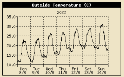
August 2022August 1 - a fine, warm and breezy morning with good visibility and 6 oktas of cumulus clouds. Pressure was steady on 1019 mb with complex low 1007 mb over the Baltic. Low 993 mb SE Greenland had associated frontal masses W of Ireland. We had a heavy shower at 1800 GMT that fell at a rate up to 26 mm/h. There was further heavy rain during the evening resulting in the wettest day of the year so far with 37.0 mm measured at 0900 GMT tomorrow. Wettest day since 30th December 2021 when 44.5 mm fell (Cardiff 24.9C Bala 7.7C Porthmadog 12.4 mm St Athan 7.2h) [Max 20.4C Min 11.9C Grass 8.3C Rain 37.0 mm] [Capel Curig 48.8 mm Mona 22.0 mm Bodelwyddan 12.8 mm]. There was thick fog at 0740 GMT and it was still foggy at 0900 GMT on the 2nd with the sky obscured so it got a rare 9 in my records. Very wet overnight with heavy rain at 0300 GMT falling at 50 mm/h and wind at 26 mph. Flood alerts had been issued for the Conwy Valley and areas near Porthmadog. Pressure was on 1010 mb with a complex low 991 mb NW Scotland and a mass of cloud cover the Irish Sea associated with cold fronts. Winds were strong in NW Wales gusting to 49 mb at Aberdaron. A sunless day, but rain had eased. With the warm wet weather there was danger of blight, the Irish Weather Service had a blight warning issued for coastal area including Pembrokeshire. There was a little blight on my outside growing Tumbler tomatoes, but not on a new variety called Tumbling Bella. Last year I lost all the Tumblers due to blight so pleased to see Bella is resistant.. There was flash flooding reported in Llanwrst where the River Conwy had burst its banks (Hawarden 24.5C Lake Vyrnwy 15.4C Capel Curig 57.6 mm Hawarden 5.8h Valley nil) [Max 18.2C Min 16.3C Rain 1.2 mm]. A brighter day on the 3rd with convective clouds developed over the mountains of Snowdonia. A cumulonimbus was spotted earlier, at 0900 GMT 5 oktas of cumulus clouds with sunny spells developing during the morning. Pressure 1010 mb was rising with low 995 mb N of Scotland while pressure was high 1023 mb Azores. Fine and breezy becoming warm in sunshine, a slight shower of rain in the evening (Monkswood 29.5C Usk 24.1C Lake Vyrnwy 13.8C Capel Curig 6.8 mm Aberdaron 11.6h Valley 5.8h) [Max 20.9C Min 14.6C Rain 0.1 mm]. A mostly cloudy morning on the 4th with spots of rain at 0900 GMT with rain over the Snowdonia Mountains. Pressure 1017 mb was rising in a ridge from Atlantic-high 1031 mb off SW Ireland. Yesterday's cold front was now over the Baltic, France and N Spain. Sunny by the afternoon (Cardiff 22.6C Lake Vyrnwy 9.9C Bala 3.3 mm St Athan 10.3h Valley 8.8h) [Max 19.6C Min 11.3C Grass 9.4C Rain 0.6 mm]. Chilly overnight the air minimum down to 8.6C and on the grass to 6.0C both lowest of the month. At 0900 GMT on the 5th the temperature had risen to 13.8C after some spots of rain. The morning was dull, but there were sunny spells by the afternoon (Cardiff 21.6C Sennybridge 5.7C Capel Curig 2.4 mm Aberdaron 10.6h Valley 8.4h) [Max 18.2C Min 8.6C Grass 6.0C Rain trace]. The 6th began very fine and sunny with a light WNW'ly breeze. Pressure was steady on 1031 mb with high 1032 mb off SW Ireland having a ridge to southern Britain. Just 3 oktas of fair-weather cumulus and cirrus clouds with very good, clear visibility (Usk 23.9C Sennybridge 2.6C Swyddfynnon 0.2 mm St Athan 13.4C Valley 12.1h) [Max 20.5C Min 9.8C Grass 6.8C Rain nil]. Another fine day on the 7th with mostly fair-weather cumulus clouds flying along on a light WNW'ly breeze. Pressure was on 1028 mb. Sunny afternoon (Frittenden 28.1C Usk 27.0C Sennybridge 3.9C NSR St Athan 14.0h Valley 13.8h) [Max 20.9C Min 12.3C Rain nil]. Pressure was high 1029 mb on the 8th in an elongated high-pressure area 1030 mb from SW Ireland to the Irish Sea. Just 1 okta of cloud cover at 0900 GMT, cumuli to the S forming a line across the Snowdonia Mountain range by 0930 GMT, the sky was bright blue. Very fine sunny and warm (Charlwood 30.0C Usk 28.3C Swyddfynnon 3.8C NSR St Athan 14.0h Valley 12.6h) [Max 22.9C Min 11.2C rain nil]. With high 1031 mb established over Britain and Ireland it was very fine, sunny and warm on the 9th with cloud increasing towards noon then decreasing later (Ross on Wye 30.1C Usk 29.5C Capel Curig 4.6C NSR Lake Vyrnwy 13.9h Valley 13.3h) [Max 23.6C Min 10.7C Rain nil]. On he morning of the 10th it was calm with very good visibility although slight pollutant smoke could be seen at low levels. The temperature at 0900 GMT t was 20.3C. Little cloud in the sky and variable light airs developed later. Soil and concrete were dry although there had been heavy dew. Watering of vegetable garden was increasingly necessary (Usk 31.8C Bala 8.4C NSR Valley 13.8h) Max 26.2C Min 13.3C Rain nil]. There was not a cloud in the sky that I could see on the morning of the 11th, the sky looked milky at lower level with slight pollution haze. At Marchlyn Mawr reservoir 2100 ft an instrument recording ozone (Welsh Air Quality Forum) measured 128 µg per m-3 increasing on a 24h average to a high 167µg per m-3 . A slight amount of a pale coloured dust was collected. Very fine and very warm (Shawbury 33.4C St Athan 33.2C Hawarden 30.9C Capel Curig 9.7C St Athan 1.8 mm St Athan & Valley and 14.0h) [Max 26.8 Min 15.1C Rain nil]. Blue sky and no clouds again on the 12th, and warm the temperature at 0900 GMT was 23.7C (dewpoint 18.1C). There was slight smoke haze and ozone levels had increased at Marchllyn Mawr to a high 154 µg per m-3 . A hot day (Wiggonholt 34.5C Usk 33.2C Bala 8.6C NSR Lake Vyrnwy 13.8h Valley 13.6h) [Max 28.8C Min 16.5C rain nil]. A covering of cirrus clouds on the morning of the 13th, hazy sunshine. Ozone level at Marchllyn Mawr was 140 µg per m-3. Very warm at 0900 GMT the temperature 26.1C and the garden with only slight breezes hung heavy with perfume from sweet peas. Sea breezes set in from the NE later (Charlwood 34.9C Usk 33.8C Gorwel Heights 31.5C Bodelwyddan 30.8C Bala 10.8C Lake Vyrnwy 13.2h Valley 13.1h) [Max 29.0C Min 18.1C Rain nil]. The first 15 days had rainfall of 40.8 mm (40%) & [45%] of the monthly mean averages. The mean temperature 18.4C was (+2.7] & [+2.8] of averages. Pressure was rising on the 16th, but the morning was dull and damp with slight rain and drizzle. Low stratiform cloud with poor visibility. There was a thundery low near Brest, France, sferics were observed crossing the Channel to the isle of Wight. Low 1003 mb was over the N Sea. The afternoon remained dull and the day's maximum 17.3C was lowest of the month (Santon Downham 26.8C Cardiff 22.1C Sennybridge 5.5C St Athan 9.0 mm Lake Vyrnwy 3.4h Valley 0.1h) [Max 17.3C Min 14.3C Grass 11.8c Rain 1.4C]. Sky ovecast on the 17th, but becoming a little brighter at 0900 GMT. Pressure 1016 mb was rising in a ridge of high-pressure to the N Scotland from Azores high 1030 mb. A cold front, associated with low 998 mb Norway to Irish Sea. There was a thundery low 1009 mb over Normandy. The sky opened up at 0920 GMT and the afternoon was sunny and the day dry (Kew 26.4C Scolton C. P. 21.8C Lake Vyrnwy 12.4C Bala 6.0 mm Valley 4.9h) [Max 20.1C Min 14.2C Rain nil]. At midnight on the 18th low 977 mb SW Iceland brought frontal cloud W of Ireland. By morning we had a moderate S'ly breeze and local dust from agricultural work on the Old Cricket Field. After shallow ploughing and rolling it was seeded and the process resulted in a lot of dust in the unusually dry conditions. There was rain in sight over the mountains with visibility moderate to good. Slight rain commenced at 0910 GMT that would hopefully lay the dust. A dull breezy day. The sky was clear in the north about 2045 GMT when green coloured aurora were seen (Heathrow 27.8C Usk 23.1C Capel Curig 10.9C and 7.2 mm St Athan 0.8h) [Max 17.9C Min 14.0C Rain 1.4 mm]. Some clear sky overnight, but by the morning of the 19th cloud was increasing. There was a moderate WSW'ly breeze and it was feeling fresher the temperature at 0900 GMT 15.6C. Pressure 1014 mb was rising. Low 981 mb was SE Iceland and a cold front was lying East Anglia to the Isle of Wight. We were in a cool cleaner Atlantic airstream. Cloudy with sunny spells and dry day (Cavendish 26.5C Cardiff 22.2C Sennybridge 5.7C Bala 1.4 mm Aberporth 10.9h Valley 6.5h) [Max 19.3C Min 1.9C Grass 7.4C Rain nil]. A very breezy and gusty day on the 20th reaching gale-force on the Snowdonia Mountains summits. Pressure was on 1014 mb with low 993 mb between Iceland and Scotland. It was raining in the NW Ireland and Scotland and S Wales. There was a slow-moving cold front over the North Channel slowly making its way down to North Wales. Fresh to strong winds in the afternoon, with some sunshine, and evening when there was light showery rain (Hawarden 22.9C Usk 10.2C Libanus 2.8 mm Valley 8.3h) [Max 19.3C Min 10.9C Rain 0.8 mm]. Slight showers of rain overnight and 0300 GMT on a cold front, but it was a bright morning on the 21st with any clouds decreasing. Pressure 1015 mb was rising with a low 994 mb Orkney and low 1013 mb SW Approaches. Sunny morning, cloudier later afternoon (Cavendish 25.6C Cardiff 24.1C Mona 11.8C Gogerddan 7.2 mm Valley 5.6h) [Max 19.5C Min 12.5C Rain 0.4 mm]. Fine and breezy on the 22nd with moderate to good visibility. Mostly cloudy with altocumulus and cumulus. Copper line broadband down for no apparent reason, reported, but told nothing wrong with it! Light to moderate rain in the morning (11.4 mm/h at 1034 GMT), the afternoon was dry with a few sunny spells (Marham 26.4C Hawarden 22.8C Whitechurch 11.5C Capel Curig 4.0 mm Valley 5.8h) [Max 19.7C Min 13.4C rain 4.2 mm]. Dull and damp, but warm on the 23rd with a few spots of rain. Frontal cloud lay over the Irish Sea 1011 mb here with low 997 mb between Iceland and Scotland. Some glimpses of sunshine (Santon Downham 28.6C Hawarden 24.3C Lake Vyrnwy 14.3C Milford Haven 2.6 mm Valley 3.3h) [Max 21.1 Min 15.2C rain 11.4 mm]. Rain overnight heavy bursts 32.6 mm/h at 0056 GMT) and 0620 GMT (14.6 mm/h). At 0900 GMT on the 24th it wasn't raining and there was a small break in the stratocumulus that was hugging the mountaintops of Snowdonia. The 11.4 mm was second largest of the month along with the 37.0 mm on the 1st the only two days in double digits. Pressure 1014 mb was rising with a cold front lying over Wales from the Western Isles to Cornwall. Brighter for a while then turned dull again Cavendish 29.5C Mumbles Head 22.6C Mona 14.6C Sennybridge 12.0 mm Valley 1.6h) [Max 19.6C Min 14.6C Rain nil]. With pressure risen to 1021 mb and on the 25th it was a fine and sunny day. Low 999 mb was now over the Norwegian Sea E of Iceland with the cold from Norway - English Channel -Atlantic W of Iberia. (Frittenden 24.0C Cardiff 23.2C Mona 6.5C Usk 1.4 mm Aberporth 9.8h [Valley 10.0h]) [Max 20.4C Min 11.2C Rain 1.9 mm]. On the 26th it was overcast with slight rain and drizzle, visibility was poor and there was little or no wind. At 0900 GMT with pressure on 1019 mb there was a frontal-wave over the Irish sea associated with low 1007 mb over the Atlantic W of Ireland. There were occasional light airs from the NE, drizzle turned to slight rain and sometimes glimpses of sunshine. There was a heavy shower of rain at 1230 GMT. The broadband mysteriously started up again today. It had been off for 4 days and according to suppliers Plusnet there was nothing wrong with it, the speed was better too (Charlwood 25.8C Usk 23.2C Swyddffynnon 6.9C Valley 11.0 mm Bala 5.3h) [Max 18.5C Min 12.7C Rain 4.7 mm]. Fine and sunny on the 27th and with high 1021 mb Dublin pressure here too was 1021 mb. The NE'ly breeze felt cool, but it was warm in the sun (Coton in the Elms 26.4C Usk 26.0C Sennybridge 6.2C Libanus 0.3 mm Valley 12.0h) [Max 19.8C Min 12.4C rain nil]. The 28th started promisingly, fine and warm with 19.1C at 0900 GMT. Pressure was on 1022 mb with high 1027 mb Norwegian Sea. There was a lot of cloud in the high and the weak sunshine diminished as the cloud thickened by afternoon. Despite the cloud it was warm and dry for a family party, gathered from far and wide, in the garden with pizza oven and BBQ in use (Bramham 25.6C Porthmadog 25.1C Bala 7.8 mm NSR Hawarden 5.6h) [Max 22.2C Min 12.7C Rain 0.4 mm]. The 29th began dull and damp after a little overnight rain. The sky was covered with moderately high altostratus cloud. This broke up later to give a sunny afternoon (Whitechurch 25.5C Sennybridge 6.4C Hawarden 1.0 mm St Athan 9.4h Valley 6.4h) [Max 21.5C Min 15.3C Rain nil]. Very fine and sunny on the 30th with 5 oktas cloud cover composed of cumulus, cirrus and a few fair-weather cumulus overhead on a cool E'ly wind. Pressure 1027 mb was rising, the high 1035 mb over the Norwegian sea had a ridge to the English Channel. A sunny afternoon (Wiggonholt 25.4C Usk 24.9C Bala 7.8C Whitechurch 0.2 mm Valley 12.0h Tiree 12.9h) [Max 19.2C Min 13.2C Rain nil]. The 31st was also a dry and fine day with plenty of sunshine. Pressure was steady on 1028 mb with Norwegian High 1035 mb. There was a low 1016 mb off Brest, France (Usk 25.1C Bala 8.3C NSR Valley 11.1h Stornoway 13.0h) [Max 20.6C Min 12.2C Rain nil]. The month ended with a total of 67.4 mm of rainfall (66%) & [75%] of averages, least since 2018 ranking 26 in Llansadwrn records back to 1928. The mean temperature 17.5C highest since 1997 ranked 3rd in station records since 1979. A sunny month with 243.4h (provisional)sunshine recorded at RAF Valley.
September 2022September 1st - began fine with broken clouds altocumulus and cumulus and good, but somewhat hazy visibility. Pressure was on 1024 mb with high 1028 mb North Sea to Azores while showery fronts were affecting N France and Kent. A sunny and dry afternoon ( ) [Max 21.2C Min 12.9C Rain nil]. The 2nd was also fine and warm the temperature already 19.9C at 0900 GMT. A few cumulus and cirrus clouds with good visibility. Pressure was high 1037 mb Svarlbard and remained high N Azores 1029 mb, hurricane Danielle was W of the Azores. Warm and sunny afternoon the temperature reaching 23.0C. Planted another row of leeks on vegetable patch, you can't have too many leeks. Heavy shower of rain at 1720 GMT falling at a rate of up to 36 mm/h water in the leeks nicely. (Porthmadog 25.2C Whitechurch 9.3C Gogerddan 7.6 mm Tiree 42.0 mm Hawarden 6.6h Valley 4.9h) [Max 23.0 C Min 13.6C Rain nil]. The 3rd began very dull the light level at 0900 GMT was only 28 W. Although the cloud was moderately high over the mountaintops it was raining. We were on the edge of a large area of rain to the NW so did not get a large fall. Pressure 1006 mb was falling with low 1002 mb was off SW Ireland with a cold front over the Celtic Sea. Pressure was high 1034 mb over the Norwegian Sea and hurricane Danielle was poised W of the Azores. The day kept dull and sunless with the best conditions around noon when light was 568 W the temperature reaching 18.9C at 1351 GMT. Dodged the rain and planted another 2 rows of purple sprouting broccoli I had spare (Hawarden 22,3C Usk 10.7C Valley 11.0 mm Tiree 62.8 mm Hawarden 0.3h) [Max 18.9C 12.8C Rain 1.3 mm]. A cold front had passed overnight and on the morning of the 4th the sky cleared rapidly. There were some cumulus clouds over mountains to the S and NE of the station, otherwise blue sky. A gusty wind at 0532 GMT, it was still breezy in the SSE'ly with moderate gusts, visibility was very good. After a fall in temperature to 13.2C at 0658 GMT it was rising again at 0900 GMT 16.9C. The MetO issued a yellow warning of thunderstorms and possibility of flash floods in SW England and Wales including Anglesey today from 8 pm overnight to 04 mm. Storms did develop near Cherbourg, France, S England, Somerset and the Midlands, even over the North Channel, but none developed here (Weybourne 26.5C Hawarden 25.5C Whitechurch 11.8C and 26.4 mm Plymouth 41.0 mm Valley 8.8h) [Max 22.9C Min 13.2C Rain 8.5 mm]. There was some rain overnight mostly slight, but a heavy burst 22 mm/h at 0141 GMT all amounting to 8.5 mm at 0900 GMT on the 5th. The S'ly wind was veering SW'ly in a clear slot between fronts, 3 oktas of developing cumulus clouds in the vicinity. Pressure 1013 mb was rising quickly with low 985 mb Celtic Sea. H Danielle was still W of Azores. Thunderstorms developed again in the S spreading N, the Snowdonia Mountains again formed a barrier and though storms reached the N Wales coast (Conwy) by evening none reached Anglesey (E Malling 26.5C Gogerddan 23.8C Trawsgoed 10.0C Capel Curig 29.8 mm Port Ellen 37.4 mm Valley 9.0h Tiree 9.8h) [ Max 22.8C Min 13.5C Rain 1.6 mm]. The 6th began fine and fairly bright with patches of blue sky to the S of the station. A complex sky with altostratus, altocumulus and cirrus clouds with lenticular altocumulus increasing at lower level towards the Snowdonia Mountains. Pressure was on 1009 mb with low 987 mb SW of Ireland. H Danielle was over the Atlantic S of Greenland W of Iberia. It was calm with intermittent light airs from the NE. There was brief heavy rain 51 mm/h at 1508 GMT and heavy thunder at 1510 GMT, followed by a fall in temperature introducing a change in the weather pattern (Shoeburyness 24.4C Porthmadog 23.2C Trawsgoed 11.2C Pembrey Sands 13.4 mm Balmoral 54.8 mm Valley 4.6h) [Max 22.6C Min 13.4C Rain 9.7 mm]. A dull and dry start on the 7th with overcast sky, but rain was in sight on the Snowdonia Mountains. Pressure was on 1004 mb and a temperature 16.6C after an overnight minimum of 13.8C. It was a day of sunshine and slight showers (Gogerddan 21.7C Lake Vyrnwy 11.3C Hawarden 20.6 mm Valley 5.8h) [Max 21,5C Min 13.8C Rain 0.2 mm]. At midnight low 992 mb was off SW Ireland and H Danielle over the Atlantic was S Greenland W of Iberia while H Earl was just S of Nova Scotia. It was a moonlit night and at 03 GMT several lenticular altocumulus were seen hovering to the SSE. By the morning of the 8th they were gone and the sky mostly cloud covered with cumulus. The weather was fair and mostly dry. Pressure was on 1002 mb with a low 997 mb Cardigan Bay. Sunny spells and a few spots of rain in the afternoon, more significant showers of rain fell in Llanfairfechan (Hawarden 20.6C Mona 10.4C Whitechurch 31.6 mm Wigonholt 35.6 mm Valley 3.8h) [Max 19.2C Min 12.6C Grass 8.8C Rain trace]. A bright morning on the 9th although cumulus clouds were increasing weather was fair. Pressure 1007 mb was rising quickly with low 1001 mb East Anglia encircled with convective clouds. Visibility was moderate to good with mist in low lying places. Sunny spells in the afternoon feeling warm in the sun we escaped the showers the day kept dry (Porthmadog 22.2C Sennybridge 8.4C Swyddffynnon 10.4 mm Valley 7.5h) [Max 20.3C Min 12.7C Rain nil]. On the 10th pressure 1018 mb was still rising the low 1008 mb now over The Netherlands. Pressure was high 1022 mb Norwegian Sea and the Pyrenees. Remnants of H Danielle over the Atlantic with H Earl in tow was 989 mb. Fine, sunny and dry day (Charlsfield 23.0C Trawsgoed 22.9C Sennybridge 10.8C NSR Durham 12.2 mm Valley 7.3h) [Max 21.0C Min 14.5C Rain nil]. A fine and mostly sunny morning on the 11th with very good visibility. Pressure 1017 mb had begun to fall with low 992 mb over the Atlantic W of Cap Finisterre likely partial remnants of H Danielle. It was raining in SW Ireland, with a warm front associated with low 1003 mb lying between Iceland and Scotland, Cork had 31.6 mm in the 24h midnight to midnight. Here sunny and a warm morning for September, harvested the last 12 lb. of good quality pink fir apple potatoes in dry soil. Rain started at 1300 GMT, a MetO yellow warning had been issued for heavy rain, but the rain here was light (Northolt 24.0C Cardiff 21.6C Bala 7.0C Capel Curig 9.4 mm Valley 1.9h Kirkwall 8.3h) [Max 20.0C Min 11.6C Grass 8.4C Rain 6.3 mm]. The temperature reached 27.2C in St James Park, London, today the 12th September. Here there was thick fog at 06 GMT and there was still fog at 0900 GMT. The sky was grey and with slight rain and drizzle it felt muggy the temperature 16.7C. Valley was on RED all morning the airfield close due to fog. It was dull and damp all day with spells of rain or drizzle, sunless (St James Park 27.6C Llysdinam 24.3C/ Mona 17.1C Sennybridge 13.1C Porthmadog 26.2 mm St Athan 0.8h) [Max 17.3C Min 16.5C rain 6.2 mm]. Much clearer very good visibility on the 13th and fine the sky becoming brighter at 0900 GMT. It felt fresher at 14.3C and 88% RH. Low AQI's today 1.0 the air could not be much cleaner with passage of a cold front overnight now lying over S Wales and central England. A little sunshine in the afternoon with the day keeping dry (Gogerddan 21.0C Mona 7.4C St Athan 7.4 mm Aberdaron 4.7h Valley 1.8h Morecambe 12.0h) [Max 16.8C Min 10.6C rain nil]. The 14th was a dull sunless day, there was a light NNE'ly breeze and it was cool. Pressure was on 1010 mb with low 989 mb Baltic. There was a weak ridge to the UK from Atlantic-high 1019 mb and 1021 mb SE Greenland (Usk 22.3C Capel Curig 4.2C St Athan 0.4 mm & 8.7h) [Max 15.7C Min 10.6C Rain 0.2 mm]. . Another dull and cool day on the 15th with pressure on 1016 mb. There was a showery airstream through the North Channel impinging upon Anglesey, although precipitation amount was very small, just spits and spots at times not showing up on the MetO radar, it made for a disappointing day. It was brighter towards the end of the afternoon when a flock of house martins and a few swallows were seen hunting overhead the station for a while. Both species have been very few and far between here this year (Pershore 20.5C Cardiff 19.9C Usk 9.2C Whitechurch 0.2 mm Aberdaron 4.0h Valley 1.0h Glasgow 9.8h) {Max 15.2C Min 11.7C Rain 0.1 mm]. The first 15 days had rainfall of 40.8 mm (41%) & [40%] of the monthly mean averages, the same as in August. Temperatures were well above averages, the mean 16.4C was (+2.3] & [+2.4]. The 16th was fine, sunny and felt fresh the humidity down to 78% at 0900 GMT. Overnight the temperature had dipped below 10C to 9.4C and had risen to 12.6C. A few cumulus clouds around over the Snowdonia Mountains and one of two blowing over the station on a light to moderate N'ly breeze. Visibility was very good and clear. Pressure 1022 mb was rising with a high 1027 mb W of Scotland and with low-pressure 985 mb over the Baltic resulting in the cool N'ly air flow. Maximum temperatures below 20C today. Masses of red fruits on honeysuckle this autumn after a great flowering season. No birds around to be interested in them at the moment (Pershore 19.4C Cardiff 19.0C Sennybridge 4.5C Bodelwyddan 3.2 mm Valley 10.8h) [Max 16.2C Min 9.4C Rain nil]. Another fine, but cool day, on the 17th with again very good visibility. Pressure was steady on 1026 mb within a North Wales high, not often that can be said. Dry with good spells of sunshine (Pershore 19.9C Usk 19.6C Swyddffynnon -0.3C & 0.2 mm St Athan 10.3h Valley 4.0h) [Max 16.3C Min 7.0C Grass 3.0C rain nil]. A mostly cloudy and calm morning on the 18th with clear very good visibility. Pressure 1024 mb was rising with a high 1025 mb near the Fastnet Rock, pressure was low 991 mb over the Barents Sea and Lapland and 985 mb SE Greenland. Detached frontal cloud lay over N Scotland, the Isle of Man and N Wales was breaking up with weak sunshine turning to sunny by the afternoon (Usk 19.4C Sennybridge 1.7C NSR Aberdaron 8.5h Valley 7.0h) [Max 17.7C Min 7.5C Grass 3.2C Rain nil]. The 19th was dull and overcast with altostratus and little or no wind before gentle airs mainly E'ly developed, A dry day (Trawsgoed 18.9C Whitechurch 4.4C Hawarden 4.4 mm Aberporth 4.8h) [Max 16.2C Min 11.4C Rain nil]. A brighter day on the 20th with pressure steady on 1026 mb with the high over Wales. Remnant detached frontal cloud over the Irish Sea dissipated resulting in a warm sunny afternoon. With tomatoes in the greenhouse finished I transferred the potted up autumn and late flowering chrysanthemums standing outside all summer to the inside. There were some good buds developing and some more disbudding was done. There has been a good crop of Black Hamburg grapes the warm sunny weather helping to ripen them (Cardiff 20.5C Sennybridge 3.3C NSR Valley 9.1h) [Max 19.1C Min 11.0C Rain nil]. Another fine and sunny morning on the 21st and still keeping dry, the surface soil looking very dry. Pressure was 1025 mb with high-pressure 1028 mb over Europe. Complex low pressure 991 mb W Norwegian Sea and 995 mb SW I had a wavy cold front stretching from Shannon, Ireland to Norway. The afternoon turned cloudy (St James Park 21.8C St Athan 20.4C Sennybridge 4.5C NSR Aberporth 5.6h Valley 1.9h) [Max 18.3C Min 10.7C Rain 0.1 mm]. It had been raining slightly since 0730 GMT on the 22nd, but it only amounted to 0.1 mm when measured at 0900 GMT, but the soil surface looked damp. A cold front stretched from Aberdeen over the North Channel to SW Ireland associated with low 990 mb Norwegian Sea. A blustery morning with slight to moderate rain continued into the evening. Pressure was lowest 1015 mb at 1534 GMT there after rising as the temperature fell away from 15.1C to 9.6C overnight (Cardiff 20.2C Usk 6.2C Sennybridge 22.8 mm St Athan 2.2h Valley 0.0h) [Max 15.1C Min 14.0C Rain 10.4 mm]. On the 23rd the cold front had reached the English Channel and pressure here had risen to 1019 mb in a ridge to the Irish Sea from Atlantic-high 1032 mb. Towering cumulus clouds were in the vicinity and cloud was increasing, but nothing much came of it and the day was quite sunny (Cardiff 20.8C Swyddffynnon 5.4C Libanus 5.0 mm Morecambe 10.7h Hawarden 9.3h Valley 7.6h) [Max 16.4C Min 9.9C rain 0.3 mm]. Pressure 1021 mb was rising on the morning of the 24th when it was fine and bright. There was a cool N'ly breeze with good visibility. High 1035 mb over the Atlantic S Iceland had a ridge to the UK. A band of convergent cloud was charted over the Irish Sea hanging off the Isle of Man, sometimes called the Pembrokeshire Dangler. H Fiona now a large storm brought unusually severe weather to the Canadian E Coast including Prince Edward Island and Nova Scotia. Slow-moving H Gaston W of Iberia appeared to be fizzling out, even retreating westward A sunny afternoon on Anglesey (Usk 19.6C Sennybridge 3.2C Scolton CP 5.6 mm Valley 5.6h) [Max 15.6C Min 9.9C Rain nil]. It had been calm in the small hours of the 25th and under open sky shallow mist had formed on the Old Cricket Field at Gadlys when the air temperature was 7.5C. By 0900 GMT this had disappeared and the sky was cloudy and the temperature risen to 11.4C, but it was still calm. Cloud began to then during the morning, but it did not clear very much. Pressure at first steady on 1022 mb in a ridge from Atlantic-high 1035 mb soon began to fall. There was a large depression N of Iceland, tropical storm Fiona was impacting NE Canada while H Gaston was still W of the Azores. Another hurricane Ian a category 4 in the Caribbean had crossed Cuba causing a complete electricity blackout there and strengthening again had entered the Gulf of Mexico heading for Florida. Due to technical problems NASA's delayed launch Artemis moon rocket, still on the launch pad, was being returned to the shelter of its construction facility fearing storm damage. Showery rain from about 21 GMT with a cold front arrived over the N Irish Sea at midnight (Cardiff 17.5C Swyddffynnon 1.7C Libanus 0.2 mm St Athan 4.2h Valley 1.4h) [Max 15.0C Min 7.5C Rain 4.7 mm]. At midnight on the 26th pressure 1007 mb was still falling bottoming out at 1004 mb at 0521 GMT. A blustery morning with a strengthening N'ly wind at 0900 GMT with rain in sight over the Snowdonia Mountains. Low 980 mb was over the Norwegian Sea with Atlantic-high S of Iceland while low 986 mb ex Fiona was SW of Greenland. The cold front was over S England and although there was the odd glimpse it was a generally wet showery day (Cardiff 17.4C Lake Vyrnwy 8.5C Swyddffynnon 18.4 mm St Athan 5.9h Valley 2.5h) [Max 14.0C Min 9.2C Rain 4.2 mm]. A mostly cloudy day on the 27th and after an overnight minimum of 8.8C and 6.8C on the grass the temperature at 0900 GMT was 11.3C. Low 989 mb was over Shetland and pressure here 1004 mb. There was a warm front over the Irish Sea (Usk 14.7C Lake Vyrnwy 6.2C Bodelwyddan 10.4 mm Lake Vyrnwy 3.8h Valley 0.2h) [Max 14.6C Min 8.8C Rain 4.2 mm]. On the 28th pressure 1003 mb was rising low 993 mb was over Denmark and with high 1035 mb NW Azores were had a showery N'ly airflow. The jetstream was looking more joined-up at high level than it has for a while, but is arched to the W of the British Isles being to the N of it. We had a sharp shower 0142 GMT and at 0900 GMT visibility was looking misty after recent and currents showers. The afternoon had some sunshine with a temperature of 15.1C at 1345 GMT then falling to a low of 7.8C at 1900 GMT. Showery rain 21 GMT to midnight. H Ian in the Gulf of Mexico tracking towards Florida. NASA's Artemis rocket has been rolled back into its assembly building for protection (Pershore 17.4C Scolton CP 14.0C Llysdinam 4.2C Gogerddan 13.0 mm Hawarden 7.2h) [Max 15.1C Min 7.2C rain 2.0 mm].
The month ended with a total of 97.5 mm of rainfall (97%) & [76%] of averages, least since 2020, but most since February. The mean temperature 14.6C lowest since 2020 ranked 7th in station records since 1979. The 127.0h of sunshine (provisional) recorded at RAF Valley was lowest since February. October 2022 October 1st - began fair though blustery with a moderate W'ly wind. With low 961 mb Iceland and Atlantic-high 1025 mb off Iberia E of the Azores pressure 1005 mb was rising quickly. Yesterday's cold front was over France. Windy through the morning, the afternoon was dry with some sunshine (Usk 18.6C and 9.4C Swyddffynnon 4.8 mm Hawarden 7.8h Valley 5.1h) [Max 16.2C Min 11.1C Rain nil]. Another dry day on the 2nd with pressure 1021 mb still rising in a developing high 1024 mb over the Celtic Sea. Low 1015 mb was over the Scilly Isles with frontal cloud masses over the English Channel and France. A nice day with a sunny afternoon and as the wind had moderated some work outside was possible. The barometer reached 1027 mb at 2036 GMT then began a slow decline (Cardiff 19.6C Porthmadog 7.4C St Athan 8.8 mm Culdrose 20.0 mm Aberdaron 9.5h) [Max 17.6C Min 9.2C Rain nil]. Little in the way of sunshine on the 3rd, but it was still keeping mild. Pressure had declined, but was was steady on 1025 mb with a high 1028 mb Belgium including southern Britain. The jetstream seemingly joined up again was high over the UK so more Atlantic weather was expected. The MetO had issued a yellow warning for high wind later affecting the north-western fringe. At midnight there was a warm front over the Irish Sea, the temperature had risen through the evening and was 14.3C. Windy overnight strong enough to break a branch off a roadside tree and bring down the telephone line, so broadband was off again. A fine and bright morning on the 10th with moderate misty visibility a cool night with air minimum 5.0C lowest since 29 April (3.9C) and down to 1.8C on the grass (1.3C) in a clear slot after yesterday's rain. Deep low 975 mb was over the Norwegian Sea while high 1027 mb NE Azores had a ridge to NW Britain with 1020 mb pressure here. A sunny afternoon (Cardiff 17.3C Bala 1.9C Katesbridge -0.1C Aberdaron 11.4 mm St Athan 9.5h Valley 8.5h) [Max 14.7C Min 5.0C Grass 1.8C Rain trace]. While moderately high altostratus cloud it was fairly dull on the 11th though with glimpses of weak sunshine at first. Pressure was steady on 1028 mb in a ridge to central England from Azores high 1029 mb over the Atlantic off Iberia. Frontal bands associated with low 997 mb lay to the W of Scotland. The afternoon was mostly cloudy with a little sunshine, mild (Plymouth 17.9C Trawsgoed 16.0C Sennybridge -0.3C Scolton 0.2 mm Tiree 5.4 mm St Athan 7.2h Valley 0.0h) [Max 14.1C Min 6.4C Rain 4.2 mm]. The 12th was a wet day beginning with light to moderate rain, very poor visibility and at times blustery. Pressure was on 1017 mb in a trough from Icelandic low 982 mb towards the North Channel. The Irish Sea was in warm sector air with a cold front over Ireland. A sunless day (Swanage 18.5C Bodelwyddan 16.3C Usk 4.1C Capel Curig 15.6 mm Bala 0.9h) [Max 13.6C Min 9.8C Rain 13.4 mm]. A clearance of cloud overnight brought a fine sunny day on the 13th with very good visibility and light airs. There was fog in places including Llyn Tegid, Bala. Pressure remained steady on 1017 mb between systems complex low 982 mb SE Greenland and low 1014 mb near Brest. Pressure was high 1029 mb Azores and 1028 mb Russia. Had a busy day in the garden (Trawsgoed 17.7C Mona 1.2C Usk 0.8 mm Thorney Island 30.0 mm Hawarden 8.8h Valley no reading) [Max 15.8C Min 5.6C Rain 2.0 mm]. It was back to being dull and wet again on the 14th with showery rain and a few glimpses of sunshine between (Usk 17.7C Hawarden 7.1C Capel Curig 10.2 mm Hawarden 3.5h) [Max 14.2C Min 7.4C Rain 4.2 mm]. The 15th began brightly, after a shower of rain at 0438 GMT that fell at a rate of 35 mm/h, with a moderately strong SSW'ly wind and developing cumulus clouds in the vicinity. At 0900 GMT just 2 oktas of cloud cover this rapidly increasing to 7 by 1000 GMT. Complex low 985 mb Rockall and 986 mb Shannon with an occlusion over Wales with the jetstream having strengthened. Pressure was lowest 995.5 mb at 0509 GMT rising to 998 mb at 0900 GMT. Showers of rain around noon with sferics recorded in south Snowdonia moving towards Manchester. Bands of showery rain passed over through the day and into the evening, thunder was heard at 1855 GMT and there was a heavy shower falling at a rate up to 83 mm/h at 2029 GMT (Cardiff 17.0C Bala 1.9C Capel Curig 31.0 mm Aberporth 6.3h) [Max 12.8C Min 8.5C Rain 7.0 mm]. The first 15 days had rainfall of 112.2 mm (80%) & [87%] of the monthly mean averages. Temperatures were above averages, the mean 12.0C was (+0.7] & [+0.9]. The 16th began fine, sunny and cooler with a scattering of cirrus clouds. Pressure 1009 mb was rising quickly with a small ridge of high pressure developed over southern Britain and Ireland with high 1025 mb near Verona, Italy. Pressure was low 982 mb Faeroes. A few cumulus clouds developed from 0945 GMT over the Snowdonia Mountains and it clouded over here by afternoon. Rainfall radar showed slight rain overhead here, the air seemed damp by there was no precipitation, but SYNOP report s indicated light to moderate rain fell to the west at Mona [5.8 mm] and Valley [18.0 mm]. Wind strengthen in the evening with pressure falling again to 998 mb at midnight with a low 985 mb Shannon (Cardiff 16.9C Sennybridge 2.8C Cardiff 13.8 mm St Athan 5.9h) [Max 14.9C Min 7.6C Rain 7.8 mm]. After an early moderate shower of rain on the 17th it was a windy morning with strong gusts reported at 47 mph at Valley and 48 mph at Aberdaron and Capel Curig. Pressure 1010 mb was rising at 0900 GMT with scattered cumulus clouds and moderate hazy visibility. Avian flu had been found at Dwyran in Anglesey and a 3 km protection zone established around the premises. After rising to 12.8C the temperature had fallen all day to 10.3C at 1650 GMT. Thereafter it rose again in a SE'ly Föhn wind off the mountains reaching 14.9C at 2249 GMT the 24h maximum (Kew Gardens 19.9C Cardiff 18.1C Llysdinam 9.9C Capel Curig 7.2 mm Hawarden 9.1h) [Max 14.9C Min 11.8C Rain trace]. Hardly a cloud in the sky on the morning of the 18th and a light NW'ly breeze. Fine and sunny (Wiggonholt 20.0C Gogerddan 18.8C Sennybridge 1.1C Whitechurch 0.4 mm Hawarden 8.7h Valley 5.7h) [Max 16.4C Min 7.7C Rain 0.7 mm]. Anglesey is not renown for its frequency of thunderstorms in any month of the year let alone October. The 30-y 1991-2020 climatological annual average for thunder is 8 days with the most 15 days in 2008. The October average is 0.7 days with the most 4 days in 2004. It is unusual therefore to have hear thunder at three different times on the same day on the 19th, in the records this would be one day of thunder, the third day of thunder in the month. A deep depression 980 mb was over the Atlantic W of Cap Finisterre and this was drawing warm air from the SE. At 0900 GMT with pressure 1019 mb falling the temperature was 12.1C (dewpoint 10.0C) RH 87% after a mild night with 13.7C recorded at 0336 GMT. The E-ESE'ly wind was light, but stronger in Llanfairfechan where 53 mph at 0423 GMT at Gorddinog and 39 mph at 0342 GMT at Gorwel Heights. There were lenticular altocumulus, well developed cumulus and cumulonimbus clouds in the vicinity with slight rain and drizzle. Thunder was heard at 0915 GMT the wind strengthened and the morning continued blustery with showers of rain. Grey and dull and wet on the ground on the 20th after the overnight rain. A warm front was lying over the N Irish Sea the temperature at 0900 GMT 12.9C after a low of 12.2C at 0525 GMT. The wind was a light E'ly and there were two glimpses of sunshine otherwise the day was dull, but mostly dry [Trawsgoed 17.8C Lake Vyrnwy 9.2C Milford Haven 1.8 mm Aberdaron 5.8h][Max 16.2C Min 12.2C Rain 0.1 mm]. On the 21st OpenReach were here to replace the overhead dropline, that was brought down overnight on the 3rd. Broadband restored after 18 days wait to come an make the repair that involved traffic management lights on the road and 3 engineers and vans. A breezy day, but reasonably sheltered behind the trees that still have many leaves attached. Pressure was a low 995 mb with low 980 mb over the SW tip of Ireland with occlusions over the Irish Sea. Pressure was high 1030 mb SE Europe and 1026 mb W of Azores. Dull at first then a brighter afternoon with some sunshine. The 200-y-old Menai Suspension Bridge was suddenly closed at 2pm on the orders of the Welsh Government due to serious safety risks. Checks had been carried out on the bridge in recent weeks by structural engineers and serious issues of corrosion were found in the hangers and elswhere. Traffic gridlock lasting hours occurred in Menai Bridge, Bangor and the Britannia Bridge as a result. Repair work could take takes weeks even months [St Athan 18.0C Bala 6.2C Capel Curig 15.2 mm Aberdaron 2.0h Valley 1.9h] [Max 17.6C Min 9.3C Rain 3.8 mm]. The 22nd was bright and breezy with moderate hazy visibility, a few cumulus clouds and sunny spells. Pressure 1005 mb was rising in a minor ridge from France [Bodelwyddan 16.9C St Athan 8.8C Sennybridge 14.2 mm Aberdaron 5.4h Valley 4.6h] [Max 16.3C Min 11.4C Rain 2.6 mm]. Light showers of rain overnight and it was dull and damp on the morning of the 23rd, but visibility was very good and clear. The altostratus cloud was high enough at first to keep the Snowdonia mountaintops clear, but soon thickening and lowering as showers developed. The S'ly wind here was force 2, but in Llanfairfechan it was force 6. Thunderstorms developed in SE England including London and northern France near Caen. Pressure 999 mb was falling with a depression NW of Cap Finisterre tracking NE. A frontal triple point SW Ireland with a warm front over N Irish Sea and a cold front over Pembrokeshire and the Severn estuary. Sunny spells and slight showers of rain. Another case of Avian flu reported near Amlwch with a 3km protection and 10 km surveillance zones established [Trawsgoed 18.6C/ Mona 17.0C Lake Vyrnwy 11.5C Milford Haven 7.2 mm Aberporth 3.6h] [Max 16.6C Min 12.9C Rain 1.2 mm]. A bright morning on the 24th with some hazy sunshine after a slight shower. Pressure 998 mb was rising with complex low 982 mb N Scotland at 0900 GMT with highs 1027 mb E Mediterranean and 1016 mb Gulf of Finland. Soon the cloud began to increase again with light showers developing [Hawarden 17.0C Mona 5.9C Capel Curig 13.2 mm St Athan 4.1h] [Max 13.9C Min 9.9C Rain 1.2 mm]. The 25th had a partial eclipse of the sun between 0910 and 10 GMT, but it was mostly cloudy here and it was not visible. Pressure was on 1008 mb with complex lows 984 mb NW of Ireland and Scotland. Pressure was high 1023 mb over the Adriatic region. With a S'ly wind there were lenticular clouds to be seen in the lee of the Snowdonia Mountains [Hawarden 18.0C Lake Vyrnwy 11.5C Mona 5.0 mm St Athan 6.8h] [Max 16.6C Min 11.0C Rain 4.2 mm]. A very blustery day on the 26th with gale force winds on high ground gusting 61 mph at Capel Curig near gale at Valley and Aberdaron. . There was a complex low 977 mb off Malin Head at 0900 GMT with a vigorous showery SW'ly air flow. Pressure 1000 mb was rising quickly after being as low as 997 mb at 0443 GMT. Little in the way of sunshine with very slight showery rain, strong wind all day [St James Park 20.5C Hawarden 18.0C Lake Vyrnwy 11.5C and 7.2 mm Hawarden 4.4h] [Max 16.0C Min 12.0C Rain 0.1 mm]. The wind had moderated by the 27th and the morning was fine after some spits and spots of rain tough the grass tops were dry. Moderate hazy visibility with the wind S'ly there were lenticular altocumulus clouds over Red Wharf Bay. It was mild the temperature 15.9C at 0900 GMT rising to 18.4C at 1152 GMT, highest of the month. At Gorwel Heights the temperature at 1220 GMT rose to 20.2C, highest of the month [ St James Park 21.0C Gorwel Heights 20.2C Bodelwyddan 19.2C Lake Vyrnwy 10.5C Capel Curig 13.2 mm Bala 2.3h] [Max 18.4C Min 12.8C Rain 5.4 mm]. Bright and breezy on the 28th as the sky cleared rapidly in the morning after recent rain. Pressure 1009 mb was rising quickly with low 983 mb W of Ireland with a triple point over the North Channel and an occluded front over N Irish Sea [St Athan 17.2C Sennybridge 10.7C Llansadwrn 6.6 mm Aberdaron 6.6h] [Max 15.4C Min 11.4C Rain 6.6 mm].The 29th began unpromisingly with overcast skies and rain with pressure 1007 mb falling quickly. Low pressure lay to the SW and there was a warm front over the Irish Sea. The sky looked brighter to the SE and with a blustery SE'ly wind there was some sunshine with just a few light showers. The afternoon at Penmon was sunny and quite warm in the lee of the Snowdonia Mountains [Trawsgoed 18.9C Lake Vyrnwy 7.2C Capel Curig 20.0 mm Aberdaron 0.2h Valley 0.0h] [Max 18.0C Min 11.4C Rain 0.1 mm]. The 30th began fair with glimpses of sunshine, but with cloud thickening rain was in sight on the mountains at 0900 GMT. Sferics were recorded over the Celtic Sea and later central and N England. Later some moderately heavy showers with a moderate S'ly breeze [Mumbles Head 16.1C Hawarden 9.9C Valley 7.4 mm Aberdaron 2.7h] [Max 14.6C Min 12.6C Rain 2.0 mm]. The 31st began with towering cumulus clouds developing over the Snowdonia Mountains. At the station it was mostly sunny with the odd small cumulus cloud scudding by on the moderate S'ly breeze. Pressure was on 1009 mb with low 981 mb NW of Scotland and with high 1027 mb near Verona there was a brisk S'ly airflow. At 1800 GMT low 994 mb was over the Scilly Isles and tracking north reached N Wales 995 mb at midnight, the wind backing NE became light before veering SW and strengthening again, while low 975 mb was W of Ireland with triple point at Cork. It began raining lightly at 21 GMT and carried on after midnight as the barometer bottomed at 995.6 mb at 0038 GMT [Max 16.1C Min 12.0C Rain 22.2 mm]... The month ended with a total of 181.0 mm of rainfall (128%) & [140%] of averages, least since 2019 but ranking 14th largest in in Llansadwrn October records back to 1928. The mean temperature 12.8C equal highest since 2001 ranked 3rd in station records since 1979. Sunshine was a little above average.
November 2022November 1st - began fine and sunny with a clearing sky after heavy rain shower 63 mm/h at 0658 GMT, parts of the Cefni marsh had some standing water. Rainfall measured at 0900 GMT for the past 24h was 22.2 mm. Pressure 1001 mb was rising quickly with complex low 991 mb over the North Sea off the Tay estuary. The low named storm Claudio by Meteo France had produced gales along the English Channel, South Wales and SE England with a gusts of 115 mph recorded at The Needles, 84 mph at St Catherine's Point and 69 mph at Mumbles Head. Low 975 mb was W of Scotland the occluded front clearing from the Irish Sea with a cold front at Brest, France. Convective clouds over the mountains of Snowdonia began to build with showers of rain coming along in the afternoon and with strengthening wind showers turned heavy again 32 mm/h at 21 GMT (Porthmadog 37.6 mm) [Max 13.4C Min 9.2C Rain 7.4 mm]. The 2nd was very dull, very windy and sunless. Pressure 1006 mb was falling quickly at 0900 GMT with low 981 mb over the Atlantic W of Malin Head and complex low 975 mb S Iceland. Gales around the coast (and over high ground with gusts of 47 mph Valley, 53 mph Aberdaron and 58 mph Capel Curig not letting up through the day. A 30 mph speed limit was imposed on the Britannia Bridge. A wet morning. At 1420 GMT Valley reported thunderstorm and rain and later sferics were seen off Point Lynas. A heavy shower at 1843 GMT fell at a rate up to 55 mm/h. High gusts reported were 75 mph at Capel Curig, 62 mph at Valley, 49 mph Gorwel Heights, 48 mph Gorddinog and 45 mph in Llansadwrn. The wind moderated after 22 GMT and the sky clearer (Libanus 52.6 mm) [Max 12.7C Min 6.8C Grass 3.7C Rain 11.8 mm]. A fine start on the 3rd after a cooler night the temperature on the grass falling to 1.6C lowest since 29 April (1.2C), but with thickening cloud rain was in sight at 0900 GMT with pressure a low 999 mb. A cluster of depression centres lay to the NW with low 976 mb N of Scotland. A warm front lay over East Anglia and Brest associated with frontal wave 1015 mb off Iberia. Hurricane Martin was W of the Azores 963 mb 1800 GMT. Showery rain arrived at 0923 GMT (39 mm/h) then becoming brighter with crepuscular rays and glimpses of sunshine in the afternoon [Max 10.6C Min 6.1C Grass 1.6C Rain 5.8 mm]. Fine and sunny on the 4th, after another cool night air minimum 4.5C, lowest since 29 April (3.9C), and 0.3C on the grass lowest since last frost on 10 April (-3.4C). There was a light WNW'ly breeze and a few cumulus, cirrus and altocumulus clouds. Visibility was good, but looked misty. Pressure 12014 mb was rising quickly with a ridge to the W of Ireland from high 1026 mb near Cap Finisterre reaching southern Britain bb 1800 GMT. Ex H Martin was 934 mb SE Greenland remnants heading our way. With the mild wetter weather grass was looking very green and had been growing at a rate of 2.4 g dry mass m -2 d -1 . This year after a slow start due to cold then dry conditions the weather station grass has produced 9.7 tonnes dry mass per hectare. Over the 18-years I have measured the yield it has ranged between 8 and 13 tonnes per hectare by this date in November. A lot of mowing [Max 12.7C Min 4.5C Grass 0.3C Rain 4.0 mm]. After one nice day it was back to overcast sky with rain on the morning of the 5th as pressure 1008 mb was falling quickly. Low 957 mb SE Greenland (remnants slow-moving ex H Martin) had a frontal triple-point over Malin Head. Mostly dull with light showers of rain and glimpses of sunshine [Max 12.9C Min 5.8C Rain 10.6C]. A breezy day on the 6th and starting mostly cloudy and thickening with some rain. Visibility was poor at first then with the sky clearing at times it was brighter with sunny spells and slight showers. Pressure 998 mb was falling with complex low 971 mb W of Ireland. Pressure was high 1022 mb Iberia and there was a shallow low 1004 mb over the eastern Med. Convective clouds developed after noon with towering cumulus and a cumulonimbus spotted at 1430 GMT to the south of the station. The afternoon had glimpses of sunshine and spots of rain at times [Max 12.7C Min 7.3C Grass 2.5C rain 7.2 mm]. The morning of the 10th was dull and very windy with a strong SW'ly. Pressure was on 1011 mb between low 996 mb SE Iceland and high 1026 mb over Europe. Isobars were lightening with a tropical air flow from the Azores. Showers overnight and recently then dry and overcast, brighter for a few minutes around 13 GMT the wind continuing strong in the afternoon gusting 47 mph at 1416 GMT (Kinloss 17.6C Dalwhinnie 7.1C Achnagart 108.8 mm Edinburgh Gogarbank 3.2h) [Max 14.0C Min 10.0C Rain 1.9 mm]. Continuing strong blustery winds on the 11th with gales on high ground. Pressure was on 1017 mb with complex low 971 mb over the Norwegian Sea with high 1038 mb SE Europe. There was a warm front over Scotland with a cold front Shannon to W of Iberia. The warm air from the tropics resulted in high overnight minimum temperatures, here 12.8C, but not up to the 13.5C recorded on the 18th in 1997, and 14.6C was recorded at Hawarden (Myerscough 19.5C Stornoway 9.8C Achnagart 77.0 mm Shoeburyness 5.5h) [Max 15.4C Min 12.8C Rain 0.2 mm]. The 12th began fine and sunny with a few cumulus and lenticular altocumulus clouds. Pressure was steady on 1024 mb with high 1038 mb SE Europe. Deepening low 975 mb was over the Atlantic to the W an d a warm front over the Western Isles. The day's temperature was highest 15.3C at noon then falling to 11.2C at 1745 GMT only to rise again in a Föhn wind 14.3C at midnight (Kew Gardens 18.2C Balmoral 2.2C Eskdalemuir 10.6 mm Morecambe 10.6h) [Max 15.7C Min 10.6C Rain nil]. The temperature at 0817 GMT on the 13th was 15.7C in a warm SSE'ly breeze with few clouds in the sky. Visibility was very good with cirrus and altocumulus. Pressure 1016 mb was falling with high 1031 mb Norway and Atlantic-low 964 mb SW Iceland. Isobars were lightening over Ireland. There was fog in central and SE England and North Wales had the highest record temperatures. At 1139 GMT the temperature here was 20.1C, a record for November, smashing the previous record of 18.7C recorded in 2003 on the 5th. Records are not broken by points these days, but by degrees. At cool Gorwel Heights the temperature reached 19.2C while at David Lee's Gorddinog the highest maximum was a record warm 20.7C. The highest went to Porthmadog returning a UK record of 21.2C (Porthmadog 21.2C Mona 19.4C Valley 18.9C Cassley 4.0C Castlederg 16.6 mm Bournemouth 7.3h Valley 4.4h) [Max 20.1C Min 11.0C Rain nil]. A fine and bright morning on the 14th after a mild night air minimum 12.6C and with the grass dry the minimum here was 7.6C. Pressure was high 1031 mb over the eastern Baltic states and here 1006 mb. Complex low 964 mb with remnants of ex-H Nicole lay somewhere to the SW, there was a cold front over the Irish Sea. Cloud soon thickened and there was rain at times with a heavier burst at 1434 GMT (Herstmonceux 17.6C Braemar 1.6C Tiree 30.2 mm Tibenham 8.0h) [Max 15.6C Min 12.6C Rain 7.0 mm]. The 15th began cloudy and dull with occasional spots of rain. It was calm, but soon s a light SW'ly picked up and a band of frontal cloud over the Irish Sea began to clear. Pressure was 991 mb with low 962 mb to the NW with a triple point over the North Channel. Pressure was high 1028 mb N Scandinavia and 1026 mb Black Sea. The afternoon turned sunny with a more normal temperature for the time of year (Chertsey Abbey 15.0C Derrylin Cornahoule 3.4C Cardinham 28.8 mm Thomastown 6.2h) [Max 10.7C Min 7.9C Rain 0.1 mm]. The first 15 days had rainfall of 119.4mm (88%) & [90%] of the monthly mean averages. Temperatures were well above normal November values, the mean 11.2C was a massive (+3.1] & [+3.3] of averages. The 16th began very fine and sunny with very good visibility. There was a little cloud on the tops of the Snowdonia Mountains and the wind was a light SSE'ly. Pressure was on 998 mb with low 956 mb W of Scotland and high pressure 1025 mb over the Gulf of Bothnia. There was a shower trough over the Irish Sea, towering cumuli could be seen in the west, a convergence front developed N Irish Sea by afternoon. A double boom was heard about 1350 GMT, possibly a sonic boom. A new low 975 mb developed over the W English Channel (St Catherines Point 14.0C Derrylin Cornahoule -0.1C Wiggonholt 40.8 mm Katesbridge 6.7h)...
The month ended with a total of 181.1 mm of rainfall (133%) & [136%] of averages, most since 2017 and ranking 14th largest in in Llansadwrn October records back to 1928. The mean temperature 9.7C highest since 2011, ranked 3rd in station records since 1979, a record 20.1C was recorded on the 13th. Sunshine was a little above average.
December 2022
December 1st - began fine with some brightness in the sky looking towards Conwy with broken altostratus cloud and very good visibility. Much of the UK, except the far N of Scotland and some coastal parts had mist and fog that was thick in central and southern England. Pressure was steady on 1030 mb with a ridge to Biscay from high 1046 mb E Europe. The sun appeared briefly around 13 GMT encouraging the temperature to rise to 10.1C. Breezes were light turning calm by the end of the afternoon (Achnagart 12.9C Redesdale -2.1C Wick 15.6 mm Liscombe 6.1h) [Max 10.1C Min 6.6C Rain nil]. After a cool night and a touch of ground frost after heavy dew it was a fine morning on the 2nd with plenty of weak sunshine. Six oktas of cirrus, contra, altocumulus and cumulus clouds made for a complex sky, visibility was good through slightly hazy. Again most inland places had mist and fog visibility down to 50 m in places. Clear sunshine was at a premium in the afternoon through the day that remained dry with gentle intermittent breezes generally from the ENE (Scilly 11.5C lo max Sennybridge 2.6C min Libanus -2.8C Lerwick 7.8 mm Bude 4.7h Valley 1.8h) [Max 9.4C Min 3.6C Rain nil]. On the 3rd the sky was clearing from broken cirrus and developing cumulus clouds forming a line across the mountains of Eryri. Fog had cleared from much of England with some persisting in Ireland and the central belt of Scotland. Pressure was on 1028 mb with a ridge from Siberian high 1056 mb reaching the Irish Sea. A deep depression over the Atlantic off Iberia was deflected SE and was filling. A pleasant cooler autumnal day with much mostly weak sunshine (Harris Quidnish 9.8C Bridgefoot -1.4C Tiree 9.6 mm Dundrennan 5.8h Valley 5.6h) [Max 7.5C Min 3.0C Rain 0.1 mm]. A dull morning on the 4th with slight rain showers here and a temperature of 4.4C, but cold enough at -2C for a little snow on the mountaintops of Eryri. Pressure was on 1021 mb and there was an ENE'ly breeze. A little brightness at times with glimpses of sunshine (Scilly 9.3C Drumnadrochit -3.8C Redesdale 13.2 mm Tiree 5.8h Valley 0.2h) [Max 6.4C Min 3.7C Grass -0.4C Rain 0.3 mm]. On the 5th a buzzard flew low over the station to say 'good day', it was mostly cloudy with breaks opening and closing until finally it was overcast and no sunshine was seen. Pressure 1027 mb was rising with high 1035 mb S Norway and 1040 mb SE Greenland. A cooler N'ly airflow was developing between these highs (Holbeach 9.2C low Aviemore 1.9C Altnaharra -6.8C Killowen 7.2 mm Tiree 6.4h) [Max 6.9C Min 4.3C Rain 0.3 mm]. 
The cold spell continued on the 10th with snow as low as 450 ft on the lower slopes of the Carneddau over the Straits from the weather station. Broken cloud with misty moderate visibility the sum shining weakly through at times. Pressure was on 1008 mb with a low 1003 mb NE Scotland. Britain was north of the jetstream with low 997 mb over Sardinia in the Med. There was a deep low 952 mb W of the Azores. Shower fronts over Wales produced some more wintry showers, a few through the day here particularly snow pellets and a spell of snow flakes at 1230 GMT [Milford Haven 7.0C low Spadeadam -0.5C Bournemouth -8.6C Inverbrevie 19.6 mm Lyneham 7.0h Valley 0.4h] [Max 3.9C Min -0.8C Grass -6.3C Pptn 4.8 mm]. Showers of ice precipitation had fallen overnight so that some snow pellets were lying on the cold ground on the morning of the 11th. The sky was overcast and the air temperature 0.7C after a minimum of 1.0C and -4.8C on the grass. The soil temperature at 5C depth was down to 2.0C and was 8.5C at 1 m depth. Pressure was on 1010 mb with a frontal wave 10076 mb over the SW entrance to the English Channel. Pressure was high 1043 mb Greenland 1030 mb Russia. Low 962 mb was NW of the Azores. The was a shower of snow grains at 0925 GMT then it was brighter by 1000 GMT but little in the way of sunshine came along (Scilly 7.7C low Warcop -2.1C Marham -8.6C Baltasound 15.4 mm Glasgow 5.9h Valley 0.9h) [Max 3.5C Min 1.0C Grass -4.8C Pptn tr]. The first 15 days had temperatures well below normal values for December, the mean 3.2C was a massive (-3.8] & [-2.5] of average. In contrast there had been little precipitation totalling 16.4 mm (10%) & [12%] of averages.. A fine frosty morning on the 16th with above zero temperature 0.6C at 0900 GMT the first in 5 mornings. The ground was still hard the temperature at 5 cm now 0.0C, but at 1 m had fallen to 7.2C. Pressure was on 1018 mb with a small high 1019 mb SW over the Atlantic. With 5 oktas of cirrus clouds and a few distant cumuli and cumulonimbus again over the Irish Sea there was weak sunshine at first becoming clearer later. There was a shower including hail at 1330 GMT (Scilly 8.8C low Kinbrace -6.3C min Loch Glascarnoch -13.5C Tiree 18.6 mm Shoeburyness 6.8h) [Max 5.2C Min 1.2C Grass -6.5C Pptn 3.7 mm]. The month ended with a total of 168.4 mm of rainfall (99%) & [124%] of averages, most since 2020 and ranking 17th largest in in Llansadwrn October records back to 1928. The mean temperature 5.1C lowest since 2010, ranked 12th in station records since 1979. Sunshine was most since 2010, sunniest day 6.2h on the 12th with 8 sunless days. The year ended with a total of 1102.4 mm of rainfall (88%) & [96%] of averages, least since 2018. The mean temperature 11.2C (+0.7) & [+0.9] of averages was highest on record in station records since 1979 and 1940 in comparative data. It was the second sunniest year on record in Anglesey. 12.3#
|
||||||||||||||||||||
| A |


