Llansadwrn (Anglesey)
Weather:
Snowdonia Snowline Report


| Llansadwrn (Anglesey)
Weather: | 
|
| |
![]() Monthly
reports
Monthly
reports
![]() Snowline
histogram
Snowline
histogram

|
¤
October
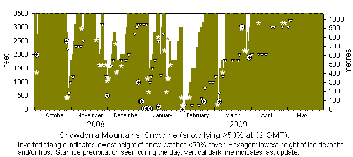
Snow fell in Scotland on the 2nd and melting snow was lying on Cairngorm. Showers in Snowdonia turned increasingly wintry overnight 2/3rd and snow was seen on the mountaintops at 09 GMT on the 3rd with some falling as low as 1200 ft near Ogwen. This was the earliest snow in October since 1994 on the 3rd, there was earlier snow on 2nd October 1981, and earliest of all in recent years on 20-22 September 1979. There was still a dusting on Snowdon in the afternoon, but was soon to melt with rising temperatures. There was no further snow until overnight 27/28th when colder weather from the north brought mixtures of ice precipitation to low levels. On the 28th there was snow lying at 2800 ft and as low as 2200 ft below the Black Ladders. There was more snow during the day and was lying between 500-1000 ft in the afternoon ![]() . On the morning of the 29th snow was lying as low as 600 ft in places with light to moderate cover above 2500 ft, there was more snow at higher levels during the day. On the 30th cover was generally above 1200 ft, but was as low as 1000 ft, deep with drifts in places, with remnants even lower. Temperatures around the summits were around -2C at 09 GMT. Snow persisted on most summits with cover from 1800 ft to the end of the month. Snow present on 6 days was most since 2003, lying snow on 4 days was most since 1993.
. On the morning of the 29th snow was lying as low as 600 ft in places with light to moderate cover above 2500 ft, there was more snow at higher levels during the day. On the 30th cover was generally above 1200 ft, but was as low as 1000 ft, deep with drifts in places, with remnants even lower. Temperatures around the summits were around -2C at 09 GMT. Snow persisted on most summits with cover from 1800 ft to the end of the month. Snow present on 6 days was most since 2003, lying snow on 4 days was most since 1993.
November
On the 1st there was snow cover generally on northern slopes from 1800 ft with remnant snow in places at 1200 ft. Snow was persisting on the 2nd although temperatures were rising; there were frequent large patches, especially in gullies on north-faces, on the 7th. Snow patches persisted, the larger hardly changing with smaller ones as low as 2300 ft. On the 10th at 09 GMT there was a little fresh snow lying on the top of C. Llywelyn following recent showers. Light snow fell overnight 21/22nd leaving a covering around most of the highest summits. There was more snow overnight 23/24th and there was a sprinkling as low as 1600 ft in places, cover was good on the slopes of the Carneddau and Snowdon was around 2000 ft. Some snow persisted until the 26th before a little fresh snow fell after a cold front had passed over on the 27th. On the morning of the 28th light snow was lying above 1800 ft and included the summit of Moel Eilio. Snow persisted on the 29th when there was frost at low levels; there was slight snow at 1500 ft and sprinklings as low as 1200 ft on the 30th. It was the most snow seen on the mountains in November since 2000.
December
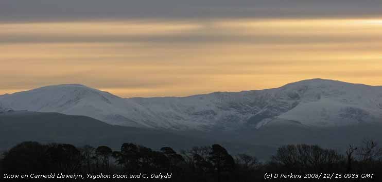
Showery precipitation overnight left a sprinkling of snow as low as 1000 ft in places, but amounts were small; frost was seen around 500 ft. On the 2nd there was fresh snow as low as 1000 ft at Ogwen and general light cover at 1500 ft and was light to moderate above 2500 ft in places on the Carneddau. Snow persisted on the 3rd, but overnight 3/4th with warmer air moving in from the west precipitation, except on the summits, was mostly of rain. On the 4th snow was much patchier and thawing, but there were several large deep drifts and cover remained around the summits. There was more snow on the 8th and on the 9th there was snow cover above 1800 ft across the mountain range and as low as 1200 ft in places including Cwm Idwal. Fresh snow was seen on the tops, especially in the east of the range, including Foel-fras and Drum on the 11th with moderate snow around C. Llywelyn. Snowdon was well covered, but Moel Eilio had only a sprinkling in addition to remnant patches. On the 12th cover had retreated to around 2000 ft with patchier snow in places at 1800 ft. Heavy rain on a warm front overnight 12/13th, fresh snow fell on the summits on the morning of the 13th as temperatures fell. On the 14th snow was lying at 2000 ft with sprinklings of fresh snow above 1800 ft and large remnant patches as low as 1600 ft. By the 16th with rising temperatures there was a rapid thaw of light coverings leaving some lying snow on the tops above 2750 ft on the Carneddau. On the 17th there was still some snow around the highest summits with snow patches thawing as low as 1800 ft. By the 19th there were some large patches remaining around C. Llewelyn with several smaller as low as 2000 ft, these disappearing quickly with rising temperatures. Snow patches persisted around the summit of C. Llewelyn and were seen at 3100 ft on the 29th. Frost occurred at low levels on the 29th and persisted in the shade in some places; temperatures at 1600 ft reached 2.5C on the 29th and 6.0C on the 31st, while some summits in sunshine were possibly also above freezing in a temperature inversion at some time during the day. Snow patches persisted around 3100 ft, and frost at low levels in the shade, until the end of the month. Present every day it was the most days with snow on the mountains since 1999. It was the most days with snow cover (17) since 2001.
January
There were snow patches at 3100 ft together with frost and ice to sea level in the first days of the month. During the afternoon of the 4th a narrow band of light precipitation, ahead of a cold front moving S, gave a sprinkling of snow as low as 1000 ft and enough for lying snow at 2500 ft. On the 5th and 6th light snow was lying at 1800 ft generally about 2000 ft across the range with ice persisting at sea level. The light snow persisted to the 8th, but by the 9th most remaining snow was on the summit around Foel-fras and Snowdon this lasting up to the 10th between Foel-grach and C. Llywelyn. On the 12th despite heavy rain overnight there were numerous patches, mainly in gullies such as on Ysgolion Duon, as low as 2500 ft. The 13th was a day of wintry showers across the summits with ice precipitation seen at 2500 ft in the afternoon.
 On the morning of the 14th there was fresh light to moderate snow lying above 2000 ft with some as low as 1250 ft near Ogwen; on the 16th there were just patches remaining around the summits these persisting until the 18th when there was a sprinkling of snow as low as 2000 ft at midday. On the 19th snow fell and was lying as low as 500 ft for a while and was between 1000 and 1500 ft on the 20th. Snow cover persisted, with more falling on the 23rd, around 1800 ft with moderate amounts around some summits until the 28th. Until the end of the month most snow was around the summits with patches as low as 1800 ft. With snow present every day and with cover on 27 days it was the most since 2001.
 On the 1st there were patches of snow and limited cover in places on the highest summits. Light to moderate snow fell overnight 1/2nd with snow lying as low as 150 ft on the 2nd with sprinklings to sea level in places. Snow had drifted on the north-facing slopes in strong to gale-force northerly winds so that depth of cover was variable.
On the 3/4th snow cover was thin in places, with little remaining on smooth slopes, while there were deep drifts in other places. There were further snow showers on the 5th and 6th with cover around 400 ft. By the 7th and 8th snow was much patchier and the snowline rising to 1000 ft. From the 10th cover was about 1500 ft, with large snow patches persisting as low as 150 ft to the 15th, with remaining cover only in places around the highest summits. On the 20th there were many linear snow patches remaining on the northern slopes beneath Carnedd Llywelyn
 ![]() . Snow patches, reducing in number, persisted until the end of the month ensuring snow presence every day, as February last year with 29 days. Snow cover occurred on 19 days, most since 2005.
. Snow patches, reducing in number, persisted until the end of the month ensuring snow presence every day, as February last year with 29 days. Snow cover occurred on 19 days, most since 2005.
Snow patches had persisted into the beginning of the month. On the 4th there was fresh light snow to 300 ft or lower in places, soon melting in morning sunshine, with light to moderate falls above 2000 ft. This light snow persisted through to the 8th above 1500 ft when there were snow showers giving further variable sprinklings at similar levels on the northern slopes. Deeper snow patches, from previous falls heavier falls, persisted upwards from 1200 ft and were frequent around the highest summits.

Cover was disappearing on the 9th and by the 10th only patches were present; most were on the north face Crib-y-ddysgl and fewer and at higher levels on the Carneddau. Patches of snow persisted until there was further ice precipitation lying as low as 2000 ft in the afternoon of the 26th and 27th. On the 28th there further light snow during the day and on the 29th in clear sunshine there was a covering as low as 2500 ft on the Carneddau ![]() and Snowdon. On the 30th temperatures were rising and on the 31st remnant snow patches remained. Snow was lying on 10 days, lowest since 2007, but was present albeit in patches every day. This was jointly highest with 2008 being the most since 2006.
and Snowdon. On the 30th temperatures were rising and on the 31st remnant snow patches remained. Snow was lying on 10 days, lowest since 2007, but was present albeit in patches every day. This was jointly highest with 2008 being the most since 2006.
There were several patches of snow on the Carneddau and Snowdon on the 1st and these disintegrated and had disappeared by the 5th.
¤

|
You can view the snowline histograms for previous years here:
![]() Winter
2007-2008
Winter
2007-2008
![]() Winter
2006-2007
Winter
2006-2007
![]() Winter
2005-2006
Winter
2005-2006
You can view complete snowline reports for previous years here:
![]() Winter
2007-2008
Winter
2007-2008
![]() Winter
2006-2007
Winter
2006-2007
![]() Winter
2005-2006
Winter
2005-2006
Observations were made as near to 0900 GMT as possible. I have a good view from Llansadwrn, weather permitting, across the Menai Strait towards the Snowdonia Mountains. I can see the northern slopes of the mountain range from Moel Eilio (west of Snowdon), Snowdon summits (Yr Wyddfa and Crib Goch), the Carneddau and to Foel-fras and Drum on the eastern end near the Conwy Valley. With the aid of binoculars I make records that include the lowest altitude of snow lying (>50% cover) and any patchy cover (<50%).
These pages are designed and written by Donald Perkins, Copyright © 1998 - 2009. All Rights Reserved.Document dated 26 September 2008 and was updated through the seasonhttp://www.llansadwrn-wx.co.uk |