Llansadwrn (Anglesey) Weather:
Snowdonia Snowline Report


| Llansadwrn (Anglesey) Weather:
|

|
|
|

|
¤
October
Snow fell on the Alps during the first week of October and on Cairngorm, Scotland, on 13th October ![]() . Temperatures were above average during the month, with the freezing level well above the summits on most days, until the 31st when overnight temperatures were lower and there were some hail showers. No lying ice precipitation was seen in the month.
. Temperatures were above average during the month, with the freezing level well above the summits on most days, until the 31st when overnight temperatures were lower and there were some hail showers. No lying ice precipitation was seen in the month.
November (14 days snow)
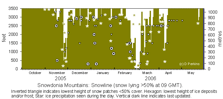
The month started with temperatures on the summits just below 2C with some wintry showers overnight on the 31/ 1st but none lying at 09 GMT. It was just cold enough for some further ice precipitation on the 6/ 7th. There was lying snow on Cairngorm on the 12th and the temperature around the summit of Snowdon was near freezing during the day. Some snow fell overnight on Yr Wyddfa giving the first lying snow of the winter above 3300 ft on the morning of the 13th. On the morning of the 16th, with further overnight snow, there was a thin covering across the summits above 2800 ft. Ice was seen as low as 2500 ft especially on the peaks around Snowdon where temperatures, indicated by the AWS, were about -3C. The sprinkling of snow was still there on the 18th and with frost down to low levels the north face of the mountains early in the day looked white. The frost melted in sunshine during the day, but there was a sprinkling of snow remaining on the summits at dusk as frost returned. Slight ice deposits remained on the tops until the 20th. After well publicised warnings of 'severe weather' it arrived in Snowdonia on the 24th. During the afternoon there were moderate to heavy showers ice pellets and sleet at low levels and snow above 500 ft . At 1530 GMT there was light 'wet' snow lying at 1000 ft. After frequent showers, mainly of snow pellets overnight at low levels, there was a slight cover generally at 500 ft by morning. With freezing temperature on the summits snow continued to accumulate slowly with some drifting in the strong winds. On the morning of the 26th light snow was lying at 1500 ft with sprinklings as low as 1000 ft. Most accumulations seemed to be on the Carneddau and around Ysgolion Duon Black Ladders. With further snow showers overnight and on the 27th snow cover remained around 1500 ft giving accumulated light to moderate cover on the Carneddau and around Snowdon. Amounts around Cwm Idwal and the Glyders were smaller. Frequent snow showers on the morning of the 28th, as low as 500 ft but not settling at that altitude, above 1800 ft there were light coverings of fresh snow. A band of snow moved across from the NW in the early hours of the 29th and brought snow as low as 600 ft in places with light accumulations at higher levels. The 30th saw a return to warmer weather and rain that led to thawing of snow cover during the day, but there was still snow lying at 1800 ft at dusk.
December
 On the 1st there was remnant snow cover at 2900 ft on the northern slopes with patches down to 2100 ft in places. Temperatures on the summits were above freezing so there was further thawing. Fresh ice precipitation was seen on the slopes of Y Garn on the 3rd. Temperatures remained just above freezing until the evening of the 5th; there were snow showers around the summits on the 6th and a fresh sprinkling of snow was lying at 2900 ft on the 7th. There was snow overnight and light snow was lying as low as 2600 ft in places on the 8th. With temperatures rising again there was a slow thaw leaving remnant patches above 3000 ft on the 11th and were still there on the 13th with frost overnight leaving ice above about 2900 ft. There were a few days without any snow before overnight 16/17th there was a sprinkling of snow over most summits. On the 17th snow was seen above 2800 ft on the Carneddau and was as low as 1500 ft around Snowdon and the Llanberis Pass but most melted during the day. There was no snow further snow up to the 25th. A sprinkling of snow was seen around Yr Wyddfa and Crib-y-ddysgl on the afternoon of the 26th. On the morning of the 27th there was a sprinkling of snow as low as 2500 ft in several places and further slight ice precipitation through the day. With airfrost overnight there was ice at low levels on the 28th. Conditions were similar on the morning of the 29th. Several frontal systems already over Ireland were expected to bring significant snowfall later in the day and night. In the event temperatures rose rapidly and after an initial snowfall the precipitation turned to rain at least at lower levels. On the 30th there was low cloud and mist so the mountaintops were obscured from view. Wintry showers occurred across the summits to the end of the month.
![]() There was snow on the Alps by the middle of December. On the 21st there was snow on the Pyrenees and the 800 miles long Apennines in Italy including the area around Corno Grande 9554 ft (2912 m) that has the southernmost glacier in Europe.
There was snow on the Alps by the middle of December. On the 21st there was snow on the Pyrenees and the 800 miles long Apennines in Italy including the area around Corno Grande 9554 ft (2912 m) that has the southernmost glacier in Europe.
January
A wet start to January with temperatures just above freezing on the summits which were obscured in low cloud and hill fog until the 3/4th. I could not see any snow but it looked icy around some summits. On the 5th there were frequent flurries of snow across the summits leaving slight sprinklings. On the 6th there was thin cover above 2900 ft, sprinklings above 2500 ft and it looked icy in places as low as 1500 ft. It was similar on the 7th and 8th but with more ice seen at 1000 ft or below. Snow was deepest on the Carneddau between Drum and C. Llywelyn remaining until the 9th. Temperatures rose after noon and rain on an Atlantic warm in the night front removed most of the snow by the morning of the 10th. After an absence of snow there was a fresh fall on summits at 3000 ft on the morning of 14th but only a trace remained early on the 15th. There were some snow flurries on the 20th. Sprinklings of snow were seen on summits above 2750 ft early in the afternoon of the 26th. On the 27th slight snow was lying above 2900 ft particularly on the eastern Carneddau and Snowdon. There were further flurries and light showers during the morning and there were dustings still present on the 28th but temperatures rose on the summit of Snowdon during the afternoon. Although below zero overnight with hard frost by the morning of the 29th there was a strong temperature inversion; 3.8C at 09 GMT compared with 0.8C on Anglesey. The temperature inversion continued on the 30th and 31st but temperatures were below zero between about 2000 ft down to 300 ft in places. Overnight on the 31st at Llyn Ogwen temperatures down to -7C were recorded, but on the summit of Snowdon the temperature was +4C or more and was 5.8C and rising at 09 GMT.
February
Snow was absent at the beginning of the month. Some frost or ice was seen on the tops and on some valley sides early on the 4th and some icicles including (Black Ladders) on the 7th. On the 8th there was ice precipitation on the summits and thin lying snow, mostly above 3100 ft but sprinklings as low as 2800 ft, on the morning of the 9th. Temperatures on the summits kept below freezing on the 10th with the small amounts of snow remaining. At 09 GMT on the 11th the temperature was about -3C but rose to zero by 1600 GMT. The mountains were obscured in low cloud and fog on the 12th; temperature was +3.5C at 09 GMT. There was ice precipitation on some summits on the 13th and again on the 16th when a sprinkling was seen on the W-facing slope of Carnedd Llywelyn at noon. By the 17th there was a very thin cover above 2900 ft across most of the northern summits. On the 18th there was a little more snow on the summits and an isolated shower had left a sprinkling at 1500 ft on the slopes of Carnedd Dafydd and was still there on the morning of the 20th but had gone by evening. On the 21st the snow at 2800 ft was being added to by frequent light showers across the summits. At 09 GMT there was a shower in the Nant Ffrancon Pass with bright crepuscular rays. With slight snow cover seen at 1500 ft in places there were further flurries of snow through the day on the 22nd, but the amounts of precipitation were again small. Temperatures remained between -3C and -5C on the tops with freezing level as low as 1000 ft and any precipitation 'sticking'. There was further slight snow during the morning of the 23rd and by noon it had turned moderate on the tops with snow lying at 1000 ft by mid-afternoon. Snow continued overnight and on the 24th was lying about 1200 ft but was as low as 800 ft in places. The variable levels were similar on the 25th with temperatures below zero on the tops in a strong E'ly wind. The 26th saw more showers on the summits with most snow remaining on the eastern Carneddau. On Y Garn the line was about 2000 ft, but it was at 1500 ft on the slopes of Foel-fras and C Llywelyn exposed to the north-easterlies. More westerly facing slopes, that had received least snow, were patchier with thawing at lower levels. Snow showers continued on the tops on the 27th with the snowline retreating during the day. On the morning of the 28th snow was lying generally above 1800 ft but with early snow showers at low level in the west there sprinklings were seen as low as 500 ft on Moel Eilio.
March

|
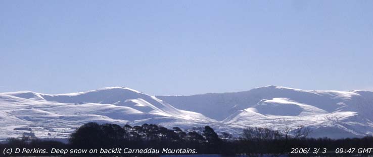
![]() On the 1st moderate to heavy prolonged showers of snow pellets and snow after midnight left 7 cm snow to sea level in SE Anglesey, mainland Gwynedd and more on the mountains. There were frequent showers during the morning with further accumulations on the summits. More heavy snow moved in across North Wales during the night. At noon on the 2nd it had been snowing heavily for some hours it was 'whiteout' on the mountains with depths of over 15 cm reported.
On the 1st moderate to heavy prolonged showers of snow pellets and snow after midnight left 7 cm snow to sea level in SE Anglesey, mainland Gwynedd and more on the mountains. There were frequent showers during the morning with further accumulations on the summits. More heavy snow moved in across North Wales during the night. At noon on the 2nd it had been snowing heavily for some hours it was 'whiteout' on the mountains with depths of over 15 cm reported.
 By 16 GMT the cloud cleared and in low winter sunshine the detailed features of the snow covered mountains were revealed. There was more snow and snow pellets as a trough passed S over the mountains around 17 GMT and showers through the night.
On the 3rd there was between 11 and 14 cm of lying snow in SE Anglesey on the mountains particularly on the Carneddau with moderate to heavy accumulations on some tops and gentler slopes. There was a good snow cover especially over 1000 ft up to the 6th. Most snow was above 1000 ft on the tops of Carneddau, the Glyders and on Snowdon above 1600 ft. Llyn Ogwen was partially frozen
 ![]()
![]() over but Llyn Mymbyr at Capel Curig at 650 ft was not. Llyn Llydaw at 1430 ft had a little ice around the edges. Overnight 6/7th warmer Atlantic air moved in from the west and there was rain from midnight. Snow was still lying at 1000 ft, but thawing quickly at lower levels. Temperatures on the summit of Snowdon were about -1C but were +2C at Llyn Ogwen. Later warm Atlantic-air and rain moved in and there was a rapid thaw. On the morning of the 8th in heavy rain remnants of snow were just enough for limited cover at 2500 ft and patches at 1000 ft. Extensive patches especially in gullies remained on the 9th. As temperatures fell again late in the day rain on the tops turned to snow overnight. On the 10th there was fresh light snow above about 2500 ft which became patchy on the 11th. Overnight 11/12th there was light to moderate snow around 900 ft with a good covering around Llyn Ogwen. On the 13th the line had retreated generally to 1250 ft with patches 900 ft, or below in places, but there had been further slight precipitation on the summits. By the 14th with temperatures rising through the night patchier cover was confined to summits mainly over 2900 ft but 2500 ft on Y Garn and the Glyders. On the 15th there were variable amounts of remnant patchy snow mainly above 2500 ft. There were frequent light snow showers during the day and there was a dusting of snow as low as 1500 ft at 16 GMT on the 16th. Just enough snow above 1500 ft to record cover (>50%) on the 17th with snow settling at 900 ft in the morning.
over but Llyn Mymbyr at Capel Curig at 650 ft was not. Llyn Llydaw at 1430 ft had a little ice around the edges. Overnight 6/7th warmer Atlantic air moved in from the west and there was rain from midnight. Snow was still lying at 1000 ft, but thawing quickly at lower levels. Temperatures on the summit of Snowdon were about -1C but were +2C at Llyn Ogwen. Later warm Atlantic-air and rain moved in and there was a rapid thaw. On the morning of the 8th in heavy rain remnants of snow were just enough for limited cover at 2500 ft and patches at 1000 ft. Extensive patches especially in gullies remained on the 9th. As temperatures fell again late in the day rain on the tops turned to snow overnight. On the 10th there was fresh light snow above about 2500 ft which became patchy on the 11th. Overnight 11/12th there was light to moderate snow around 900 ft with a good covering around Llyn Ogwen. On the 13th the line had retreated generally to 1250 ft with patches 900 ft, or below in places, but there had been further slight precipitation on the summits. By the 14th with temperatures rising through the night patchier cover was confined to summits mainly over 2900 ft but 2500 ft on Y Garn and the Glyders. On the 15th there were variable amounts of remnant patchy snow mainly above 2500 ft. There were frequent light snow showers during the day and there was a dusting of snow as low as 1500 ft at 16 GMT on the 16th. Just enough snow above 1500 ft to record cover (>50%) on the 17th with snow settling at 900 ft in the morning.  Amounts of precipitation were very small and the settling level rose to 2500 ft by the afternoon. There were only small amounts of remnant snow left on some summits on the 20th, but there was deep blown snow between Foel-fras and Carnedd Llywelyn. On the 21st at 09 GMT there was fresh powder snow with light cover at 1500 ft on the Carneddau and Snowdon. There was good cover remaining above 2500 ft on the 22nd, especially on the Carneddau with deep snow between Foel-fras and C. Llywelyn with some cornices formed as a result of the persistent strong easterly winds. There was snow also on the summit of Yr Wyddfa, Crib Goch and within the 'horseshoe'; with temperatures keeping well below freezing there were icy patches and frozen waterfalls down to 1500 ft or below in places were glinting in bright sunshine. Snow cover lasted until the 24th when, with rising temperatures and heavy rain, only patches remained but persisted until the end of the month.
There was fresh snow on some summits over 2750 ft on the morning of the 1st. On the 2nd ice precipitation occurred in frequent showers in strong winds across the summits. There was light snow on Carnedd Llywelyn and Snowdon above about 2900 ft on the 3rd to the 5th . There were small amounts of snow on various summits on the 6th and 7th generally above 2800 ft. Overnight 7/8th there was a fresh fall of snow that was lying thinly at 1200 ft on the morning of the 8th. There was more light snow on 9/10th and early in the morning of the 10th there was a light covering as low as 750 ft, but later the snowline was 1500 ft. Overnight on the 10/11th there was heavy rain and the mountains were obscured in low cloud and fog on the 11th. When the cloud cleared in the afternoon there was still snow lying at 2500 ft and it was cold enough for a sprinkling of fresh snow in showers. By the 12th temperatures were above freezing and most, except some deeper patches, had thawed. A large gully snowbed was still visible on the NE-facing slope of Carnedd Llywelyn that persisted to the end of the month.
MayThere was still a little left on the 1st of May, but it had gone by the 3rd. Following heavy rain the weather turned colder overnight 22/23rd and there was ice precipitation on the summits of the Carneddau and Yr Wyddfa and was lying at 2800 ft on the 23rd.
¤

|
You can view the snowline histograms for previous years here:
![]() Winter 2004-2005
Winter 2004-2005
![]() Winter 2003-2004
Winter 2003-2004
![]() Winter 2002-2003
Winter 2002-2003
You can view complete snowline reports for previous years here:
![]() Winter 2004-2005
Winter 2004-2005
![]() Winter 2003-2004
Winter 2003-2004
![]() Winter 2002-2003
Winter 2002-2003
Observations were made as near to 0900 GMT as possible. I have a good view from Llansadwrn, weather permitting, across the Menai Strait towards the Snowdonia Mountains. I can see the northern slopes of the mountain range from Moel Eilio (west of Snowdon), Snowdon summits (Yr Wyddfa and Crib Goch), the Carneddau and to Foel-fras and Drum on the eastern end near the Conwy Valley. With the aid of binoculars I make records that include the lowest altitude of snow lying (>50% cover) and any patchy cover (<50%).
These pages are designed and written by Donald Perkins, Copyright © 1998 - 2006Document dated 29 September 2005 with updates during the seasonhttp://www.llansadwrn-wx.co.uk |