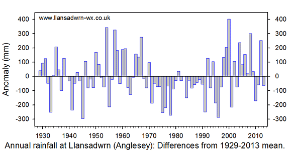
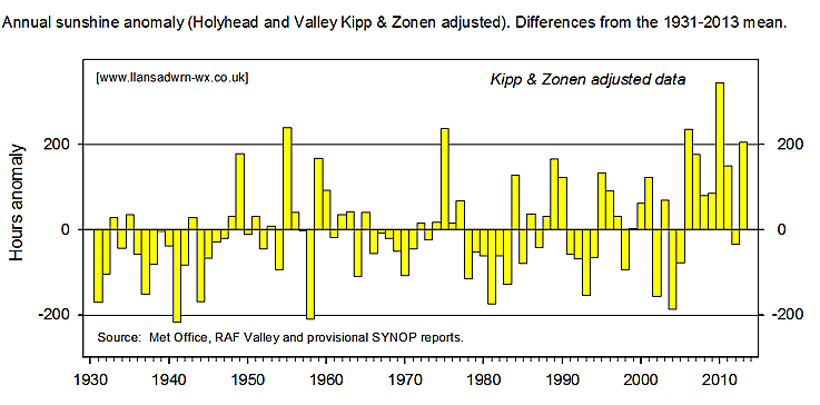
|
January 2013Below average precipitation, temperature and sunshineCold with snow in the middle of the month
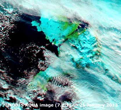
Rainfall in Llansadwrn was 70.4 mm (67%) and [69%] of averages, lowest since 2010 and ranking 20th since 1928. Most 15.5 mm fell on the 25th after the snowfall, precipitation during the snow event was 6.0 mm, most 4.1 mm on the 18th giving rise to the 11.5 cm of lying snow on the 19th. There were 2 days (-5.0) without any precipitation; 12 dry days (+1.2); 18 rain days (-2.2); 16 wet days (0.3); and 6 (-1.4) had 5 mm, or more. Rainfall at Gorwel Heights in Llanfairfechan totalled 58.2 mm with the wettest day 15.2 mm on the 25th close to Llansadwrn. Ice precipitation fell in Llansadwrn on 7 days (+1.6) and were either ice crystals (2 days) or snow pellets (3 days). There were 2 days at the end of the month with ice pellets. The mean temperature in Llansadwrn was 4.8C (-0.5) and [-0.3] of averages, lowest since 2011 and ranking 12th since 1979. The mean maximum was 6.9C (-0.8) & [-0.7] of averages and in records ranked 9th highest. The highest maximum was 11.3C (-0.2) on the 29th while the lowest 0.9C (-1.9) was on the 19th. The mean minimum was 2.7C (-0.2) & [-0.3] of averages. The highest minimum was 9.3C (+0.6) on the 8th and the lowest -2.8C (-0.6) was on the 22nd. There were 10 air frosts (+4.8), most since 2010. There were 18 ground frosts (-0.2), the lowest grass minimum was -6.6C over snow on the 22nd. Lower over snow minima have been observed in the past under clear skies (-10.0C in 1987), this January nights were mostly cloudy. The mean temperature at Gorwel Heights was 5.8C (+1.0 cf. Llansadwrn); the mean maximum 8.0C (+1.1 cf. Llansadwrn); and the mean minimum 3.6C (+0.9 cf. Llansadwrn). The positive differences due to topography - downslope airflows, and enhancements due to Föhn-like winds that were frequent this month. Global solar radiation in Llansadwrn averaged 2.66 MJ m -2. Highest were 5.62 MJ m -2. on the 24th and 5.61 MJ m -2. The 29th was a particularly dull day with 0.70 MJ m -2 recorded. Other dull days were the 18th (when it snowed) and 9th with 0.74 and 0.76 MJ m -2 respectively. There were 12 sunless days the dullest January since 2008.
February 2013Sunny and cold, near average precipitationThe 13th was a very wet day, the latter half of the month dry, cold and sunny Temperatures were below the averages and lowest since 2010. The mean 4.3C (-1.2) & [-0.8] was lowest since 2010 ranking 8th since 1979. On 19 days the mean was below 5.6C (42F). The mean maximum 7.2C (-1.2) & [-1.1] ranked 7th lowest while the mean minimum 1.4C (-1.2) & [-0.8] ranked 12th lowest. There were 6 days with air frost of 44.2 hours duration, lowest was -2.7C on the 21st, and 20 days (+5.0) had ground frost. Lowest grass minimum was -6.8C on the 22nd while -6.5C was recorded on the 21st. The temperature in the soil at 30 cm depth averaged 4.7C (-0.7) and at 100 cm deep 6.3C (-0.6). The ground was frozen on the 12th and during a spell 18 - 24th frost penetrating to a depth of 5 cm on the 22nd. The highest maximum was 12.1C on the 18th, one of the 4 days 16- 19th to reach double digits. At Gorwel Heights, Llanfairfechan, the mean temperature was 4.8C. The mean maximum was 7.0C and the mean minimum 2.6C. The maximum temperature reached 10C, or more, on 6 days. There were 16 days with a mean below 5.6C (42F). The highest maximum was 11.3C on the 13th and the lowest 2.9C on the 22nd. There were 3 days with air frost having a total duration of 17.7 hours. Lowest was -1.0C on the 22nd. Rainfall and ice precipitation, totalled 73.5 mm in Llansadwrn, largest since 2011 (96.5 mm) ranking 38 since 1928. The wettest day on the 13th had 32.1 mm and fell at up to 11.2 mm per hour. There were 16 (-1.0) wet days and 5 (+0.9) with 5 mm, or more. Rain days were 14 (-2.5). Days with no precipitation numbered 11 (+5.1) and dry days 14 (+2.2). At Gorwel Heights rainfall was 59.4 mm, wettest day was the 13th with 23.2 mm that falling at a rate up to 21 mm per hour. Wet days were 11; 4 had 5 mm, or more. Dry days numbered 15. Sleet or snow fell in Llansadwrn on 4 days (+0.4) and hail on 7 days (+2.1). Ice crystals fell on the 12th, snow pellets on 5 days and ice pellets on 1 day. There was no lying snow. A partial solar halo with right hand parhelion (sun dog) was seen at 0900 GMT on the 28th.
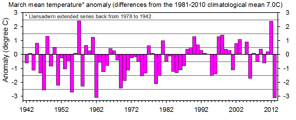
March 2013Equal coldest with 1962 since before 1942. Near average precipitation last 10-y, below 30-y. Record days with ice precipitation.Began warm then cold, turning very cold and dry, as the month progressed with several station records broken.
There were 14 (+10.6) air frosts, highest on record in March since before 1979, soundly beating the previous 11 days of 1985. Ground frosts were 20 (+10.6), highest on record since before 1985 beating the 18 recorded in 2010. There were 14 days on which sleet or snow were observed (+11.8) on the average over the past 10-y. Most on record in March since 1979, beating the previous 13 in March 1995. Amounts of water were often very small (trace) despite there being precipitation several times during the day on the 24 - 27th. Occasionally the ground was whitened by snow pellets and or snow especially at night, for example about 02 GMT on the 27th. There was no snow lying (at 0900 GMT) in the month (-0.8). There were 15 (+9.7) days with hail most on record in March, exceeding the 12 days seen in March in 1995 and 2008. Snow pellets were frequent (12 days), often seen with snow flakes. Ice pellets were recorded on 1 day the 15th, snow grains were seen on the 24th and ice crystals on the 25th. There was no thunder. Total precipitation was 60.1 mm (91%) & [71%] of averages, largest since 2010 and middle-of-the-road ranking 43 since 1928. The largest fall 11.0 mm of rain on the 7th. Days with no precipitation were 9 (-0.5) and dry days 19 (+3.5). Rain days were 12 (-3.5), wet days 10 (-1.2) and days with 5 mm, or more 6 (+1.6).
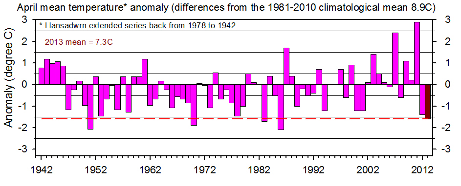
April 2013Coolest since 1986, only 75% of normal rainfall, 9th sunniest since before 1930.Temperatures kept below average through the month, rainfall fairly evenly distributed.
Soil temperatures too have been on the low side, the mean at 30 cm 7.8C (-2.7) and 100 cm 7.7C (-2.3). All depths were <10C at 0900 GMT except at 5 cm which rose to 10C, or more on 7 mornings, and at 30 cm on the 24th. Soil moisture following flooding earlier in the year kept at or near water saturation percentage through the whole month despite evaporation that more or less balanced precipitation. Potential evapotranspiration was 42.6 mm by lysimeter (PWB was 4.7 mm); 54.9 mm by AWS calculation; and 52.6 mm by Piche evaporimeter. Rainfall was 47.3 mm (73%) & [75%], lowest since 2011 (45.3 mm) and ranked 30th in records since 1928. Largest fall was 10.7 mm on the 13th. Days with no precipitation were 11 (+0.1) and dry days 12 (-2.9). Rain days were 18 (+2.9) and wet days 14 (+3.5). There was only 1 day 5 mm, or more, (-3.3). At Gorwel Heights a drier month too with 38.4 mm. Dry days 15; rain days 15; wet days 10; and 2 with 5 mm, or more. Largest fall was 7.2 mm on the 14th. Wet hours totalled 52, there were 74 in Llansadwrn. Windy at times with a mean wind speed 17.4 mph recorded on the 16th and gusts of 53 mph on the 17th and 50 mph on the 18th. At Gorwel Heights 61 mph was recorded on the 15th with a mean wind speed of 16.8 mph; 57 mph on the 17th and 18th. Sunniest since 1998 and 9th sunniest April on Anglesey record since 1930.
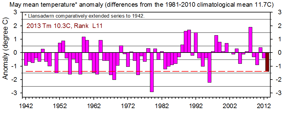
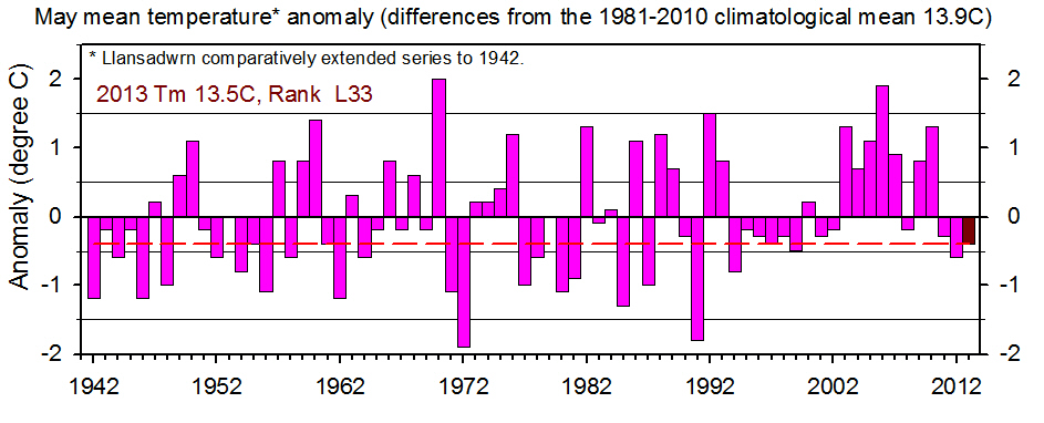
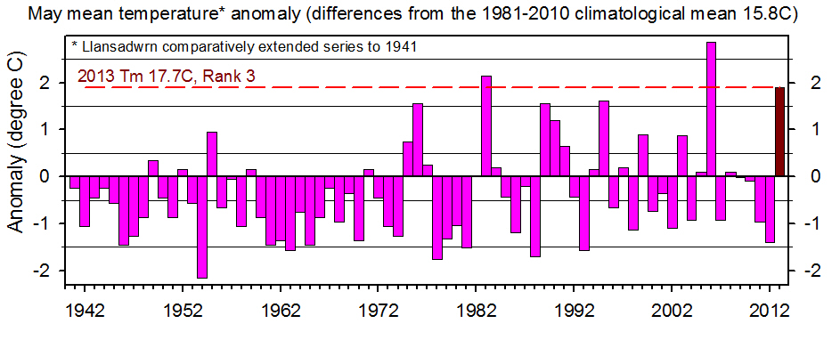
May 2013Temperatures in fifth consecutive month below average'Summer' temperature for a day in the first part, warm day on the 31st prevents coldest spring record, sunny at times, sometimes wet
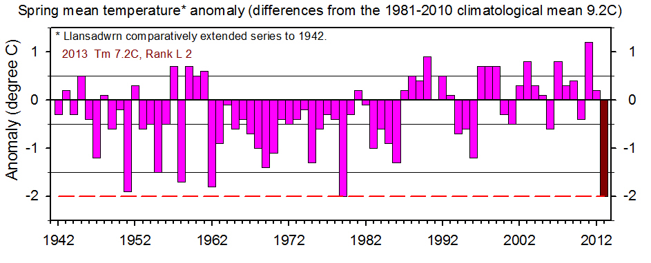
Soil temperatures also continued on the low side with the mean 11.6C (-1.8). temperatures at all depths reached 10C, or more, for the first time this year on the 4th. The soil surface was dry on 13 mornings at 0900 GMT and samples taken on the 'bare soil plot' showed a moisture content of 21% DM on the 22nd just 6% above permanent wilting point. Moisture content under grass, however, was 52% DM. Evaporation ET measured by the AWS was 68.6 mm and mirrored the PE of the lysimeter 68.7 mm. This showed a potential water balance of -16.3 mm and a potential water deficit of 47.2 mm. May sunshine at Valley (provisional SYNOP data] 192.4 h (96%) & [99%] was lowest since 2011 ranking 41 on the Anglesey record since 1930. Spring 2013Spring was remarkable because of its below average temperatures, late development of spring plants and arrival of summer birds. The chiffchaff (a harbinger of spring) was heard in the garden on the 10th of April, later than usual, but 2 days earlier than the latest garden arrival date 12 April 2001
June 2013Another month with below average temperatures, drier and sunnier than average especially on western coastsFine and sunny at the beginning turning wet on the 12th, end of month mostly dull and sometimes windy
Soil temperatures continued below average, the mean at 30 cm deep 15.0C (-1.2) and 100 cm deep 13.4C (-1.2). Rainfall in Llansadwrn was 58.3 mm (79%) & [86%] of averages, lowest since 2011 and ranking 38th back to 1928. The largest daily fall was 13.7 mm on the 12th while the following day 13th had 12.2 mm. The spell 11 - 13th totalled 28.1 mm 48% of the total for the month. Gorwel Heights was drier having 42.4 mm with the largest 11.2 mm falling on the 27th. There were 13 (+0.9) days with no precipitation in Llansadwrn while dry days numbered 16 (+0.7) with 14 at Gorwel Heights. Rain days were 14 (-0.7), 16 at Gorwel Heights; wet days 11 (-0.2), 11 at Gorwel Heights; and days with 5 mm, or more 4 (-1.0), 4 also at Gorwel Heights. A sunny month at Valley the 225.2 h of sunshine was most since 2010 and the 10th highest on the Anglesey record (K&Z adjusted values) since 1930. While Valley recorded just 1 sunless day in Llansadwrn, influenced by the Snowdonia Mountains, 6 were logged. The brightest day was on the 5th with 26.72 MJ m -2 and the dullest 5.87 MJ m -2 recorded on the 28th while the 12th, almost as dull, had 6.19 MJ m -2..
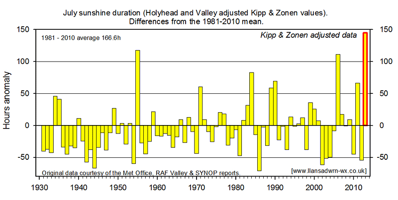
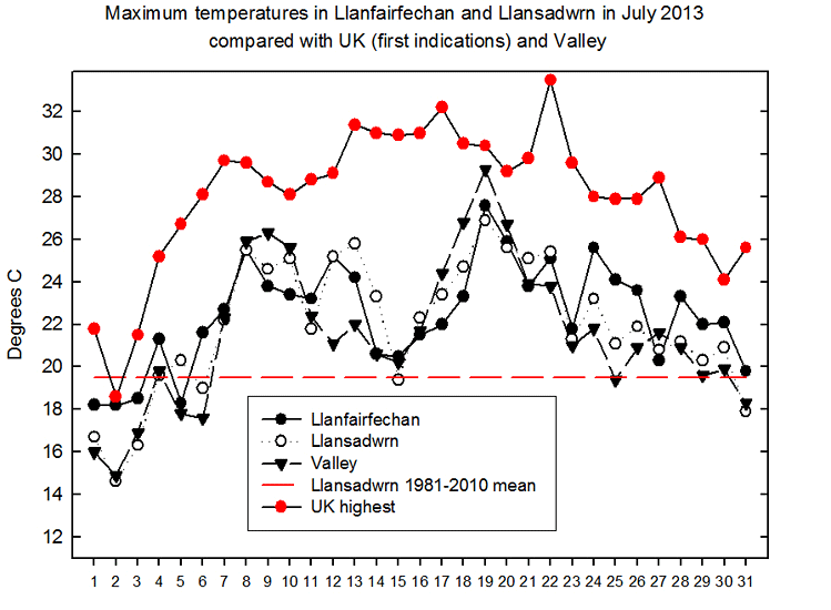
July 2013Sunniest on Anglesey record, third warmest since 1941 and driest since 2006Mostly sunny and warm throughout with drought between 4th and 22nd.
The mean soil temperatures at 30 cm 18.1C rose above average (+0.7) for the first time this year, but at 100 cm the mean 15.8C remained stubbornly just below (-0.2). Rainfall was 59.8 mm, lowest since 2006, ranking 28 lowest since 1928. An 18-d spell without measurable rain occurred between 4th and 26th, a drought. Rainfall on the 28th 13.5 mm and the 31st 16.8 mm went a long way to build the month's total. Rainfall for the year to July totalled 421.6 mm and remains below the total 459.2 mm reached in July 1945 the driest year on record in Llansadwrn, and well below the long-term average 527.1 mm. The soil became very dry and parched and soil moisture under grass dropped to 25.6% dry mass on the 24th. Soil moisture on the bare plot fell to 11.9% below the permanent wilting point of 15.2% for the local soil. Plants on bare soil were wilting, and fine leaved shallow rooting grasses were becoming desiccated. Deeper rooted meadow grasses kept green and no wilting was seen on mature trees that were affected in the drought of 1976. Evaporation levels were high; calculated ET from the AWS was 93.3 mm, PE measured by lysimeter was 88.7 mm with a PWB potential water balance of -29.1 mm. Days without any precipitation were 19 (+9.6) and dry days 21 (+7.7). Rain days were 10 (-7.7), wet days 6 (-8.0) and days with 5 mm, or more, 4 (-2.3). Wet hours were 53. Rainfall at Gorwel Heights was similar totalling 58.8 mm with 45 wet hours recorded. Dry days were 21; raindays 10; wet days 7, and 4 days with 5 mm, or more. August 2013Near average temperatures, rainfall and sunshineRecord daily rainfall at this station on the 4th; dry from the 16th
There were 14 days with no precipitation (+6.5) and 16 (+3.3) of them were dry. Rain days numbered 15 (-3.3) and wet days 10 (-2.6). Days with 5 mm, or more, were 4 (-1.6). At Gorwel Heights 57.0 mm fell on the 4th (14 wet hours) and the month's total was 102.2 mm. There were 20 dry days and 11 rain days. Wet days were 9 and those with 5 mm, or more, were 3. There were 56 wet hours duration. Rainfall January to August 558.2 mm After July's record amount of sunshine August seemed rather dull, but there were 162.9 h recorded at RAF Valley this lowest since 2010 (106%) & [101%] of averages (K&Z adjusted) and ranking 33 on the Anglesey record since 1930. Four days saw 10h, or more, the sunniest day was on the 7th with 14.2h. The 2nd and 3rd had 13.3h and 12.4h respectively and the 25th 12.6h. There was 1 sunless day. Solar radiation is falling off this month after the June-July peaks. The brightest day was on the 3rd with 24.51 MJ m -2 and the dullest on the 17th having just 4.21 MJ m -2, but even then,it brightened up after 1800 GMT with a few glimpses of evening sunshine, so there were no sunless days in Llansadwrn. August was an average month for temperatures here in the north-west. The mean 15.8C [(+0.2)] of averages, was lowest since 2011, but nevertheless ranked 11th highest since 1979. The mean maximum 19.2C (+0.2) & [0.0] was highest since 2005 and ranked 12th. Highest was 22.3C (-2.0) on the 1st and lowest 16.8C (+1.9) on the 5th. The mean minimum was 12.4C (+0.1) & [+0.4]. Lowest minimum was 7.8C (-0.6) on the 31st that also had the lowest grass minimum of 3.0C. The mean soil temperature at 30 cm was 17.3C (0.0) and at 100 cm 16.6C (+0.2). Soil moisture under grass recovered from the July low of 25.6%, after the heavy rain on the 4th, and was 48% dry mass on the 16th. Soil on the bare plot that had gone down to 11.9%, below the permanent wilting point, reached 29%. The rain restored the water balance (PWB) to 82 mm, but with continued moderately high evaporation (PE 54.6 mm) and (ET 59.5 mm) surface soil was dry on 10 mornings especially at the end of the month. Vegetables, particularly lettuce and spinach, needed irrigation again from the middle of the month, but grass continued to look green and lush without irrigation and there was no wilting seen on mature plants and trees. Summer 2013Summer temperatures were above average both on the 10-y and 30-y averages. Rainfall was 99% of the decadal average, but 113% of the 30-y average.
September 2013A rather dry and dull month, temperatures a little below averageWarm with a wet day at the beginning with two cool spells in the middle. Warmer at the end. Sunshine was at a premium with 100.2h recorded at Valley [(79%)] of K&Z adjusted average, lowest since 1977 ranking 14th on the Anglesey record since 1930. Sunniest day was the 14th with 9.3h and there were 4 sunless days. Bala had only 75.9 h [69%] while across the Irish Sea Dublin clocked up 138.4h [106%]. The 80.7 mm rainfall (66%) & [84%] of averages was lowest since 2009. Gorwel Heights in Llanfairfechan was drier with 59.0 mm. The wettest day in Llansadwrn was on the 6th having 26.5 mm and at Gorwel Heights on the 17th with 13.0 mm. Wet hours were 97 and 78 respectively. Maximum rainfall rates were 61 mm/h in Llansadwrn on the 7th and 47 mm/h on the 6th; and 36 mm/h at Gorwel Heights on the 6th and 35 mm/h on the 7th. In Llansadwrn there were 7 (-1.0) days with no precipitation, but 13 (+5.0) dry days. Rain days totalled 17 (-0.6) and wet days 13 (+0.1). Days with 5 mm, or more, were 6 (-1.3). At Gorwel Heights there were 15 dry days, 15 rain days and 10 wet days with 5 having 5 mm, or more. The mean temperature was 13.6C (-0.5) & [-0.2] of averages, lowest since 2011 and ranking 15th since 1979. The mean maximum was 16.6C [(-0.7)], highest were 22.6C on the 4th and 22.0C on the 27th and were the only 2 to reach 20C, or more. The lowest maximum was 11.6C on the 17th. The mean minimum was 10.6C (-0.4) & [+0.3], lowest was 7.4C (+0.7) on the 6th and 14th in 2 spells of 4-days and 5-days of sub-10C temperatures. In all there were 10 days with minima below 10C. The lowest grass minimum was 3.4C (+0.6) on the 15th one of 8 days at, or below 5C. The mean temperature at Gorwel Heights was 14.3C, highest 19.3C on the 3rd and lowest 10.1C on the 16th. The mean maximum was 17.0C, highest were 23.0C on the 21st and 22.9C on the 3rd. There were 7 days on which the temperature reached 20C, or more, 5 more than Llansadwrn. The lowest maximum was 11.4C on the 17th when, during the day (00-00z) the highest was 10.7C at 1530 GMT, following the temperature falling to 7.8C at 1030 GMT during a heavy shower of rain.
October 2013Above average temperatures, near average rainfall but below average sunshineTemperatures especially minima were mostly above average. The mean 12.6C (+1.3) & [+1.7] was highest since 2006 ranking 5th since 1979. The mean maximum highest since 2011 was 14.7C (+0.4) & [+0.7] and ranked 10th. The highest maximum 19.2C on the 2nd was (-0.6) while the lowest 10.7C on the 10th was (+1.2). The mean minimum 10.4C highest since 2001 was (+2.1) & [+2.7] while the lowest 5.3C on the 30th was (+1.9). The grass minimum mean was 7.6C and (+2.0) with the lowest 0.8C on the 24th (+1.2) there were no grass frosts (-1.3). Total rainfall 137.9 mm (97%) & [107%] was highest since 2008 and ranked 31st since 1928. The wettest day was on the 3rd when 18.0 mm fell. There were 4 days (-3.6) with no precipitation including the 3-day spell 10 - 12th. Dry days numbering 6 (-4.9) were at a premium this month. Rain days were 25 (+4.9) and wet days 17 (+1.3). There were 10 days on which 5 mm, or more, fell these (+2.4). Sunshine duration at Valley was 72.5h (75%) & [74%] of the K&Z adjusted values, lowest since 2011 and the 13th dullest October on the Anglesey record since 1031. The sunniest day was late in the month on the 23rd with 6.9h; there were 5 sunless days. Solar radiation declines rapidly this month and the brightest day was on the 5th with 9.05 MJ m -2 while the dullest with 1.82 MJ m -2 was on the 16th. November 2013Very dull, but dry; temperatures a little below averageStormy and wet at the beginning, then cooler with days of ice precipitation. A dry month with total rain fall 71.8 mm, lowest since 2011 and ranking 14 since 1928, (55%) & [57%] of averages. The wettest day was on the stormy 2nd with 12.5 mm and there were 93 wet hours. There were 3 days (-1.9) with no precipitation and 7 dry days (-1.9). Rain days were 23 (+1.3) and wet days 17 (-0.6). There were 7 days (-1.4) having 5 mm, or more. Rainfall at Gorwel Heights, Llanfairfechan was 80.8 mm with 94 wet hours. Wettest day was on the 6th with 12.2 mm. There were 22 rain days and 15 wet days. Highest rates of rainfall on the 2nd were 61 mm/h in Llansadwrn and 63 mm/h at Gorwel Heights. All mean temperatures ended the month a little below average. The mean air temperature 7.2C, lowest since 2010 rank 13, was (-1.5) & [-0.8] of averages. The mean maximum 9.6C, lowest since 2010, was (-1.5) and [-0.2] of averages; the highest maximum was 13.7C on the 11th and the lowest 6.6C on the 22nd. The mean minimum 4.8C, highest since 2011, was (-0.8) & [-0.5] of averages. The lowest minimum was 1.2C (+0.9) on the 19th. The lowest grass minimum was -3.5C (+0.2) on the 23rd and there were 12 days (+5.2) of ground frost. At Gorwel Heights the mean temperature was 8.0C, mean maximum 10.0C and mean minimum 6.1C. Highest maximum temperatures in a Föhn wind were 15.7C on the 10th between 0830 and 0900 GMT one of the highest UK temperatures on the day (Shap Fell 15.8C) and 15.6C on the 11th until 0920 GMT. There was a thunder storm on the 2nd that widely affected the telephone system in SE Anglesey. Several homes were affected by blown terminal boxes and other faults, including damaged TV sets, and were off for several days until repairs effected. Ice precipitation fell on 7 days (+0.7) with snow on the 19th and large hail H5 (7 mm) on the 8th. It was a very dull month with 13 sunless days in Llansadwrn and 12 reported at Valley. Sunshine duration at Valley was 48.5 h lowest since 2004 ranking 24th lowest on the Anglesey record since 1931. The sunniest day was on the 12th with 7.1h. Solar radiation values at Llansadwrn continued their decline with the mean for the month 3.28 MJ m -2 . Highest was 6.21 MJ m -2 on the 3rd, but the 9th and 10th were almost as bright with 6.20 and 6.18 MJ m -2 respectively. There were some very dull, dark days, the 27th was dullest having 0.98 MJ m -2. Autumn 2013It was a dry autumn the 290.4 mm rainfall lowest since 2007 ranking 23 in Llansadwrn since 1928. The mean temperature 11.1C was lower than the last decade (-0.2), but [+0.3] based on the 30-year average. The mean maximum was below both averages (-0.7) & [-0.3] while mean minimum was above (+0.3) & [+0.9] reflecting cloudiness and warming trend. Unless December is wet year 2013 could be a dry one; the rainfall to November 848.6 mm (83%) & [88%] of averages and ranking 20th since 1928. December needs have 113 mm to bring the year up to the long-term average; the December's LTA is 115 mm.
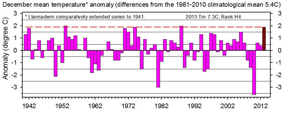
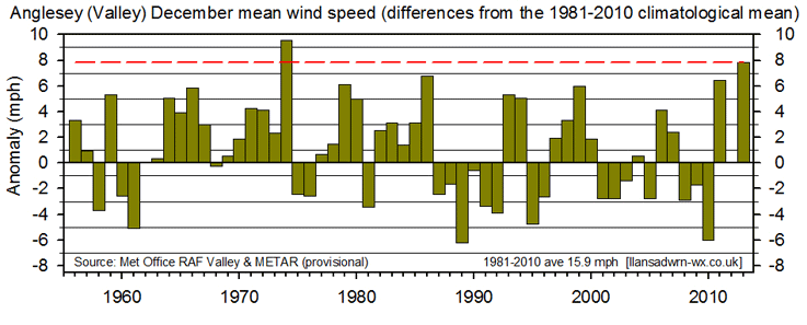
December 2013Mild, wet and stormyThe second half of the month was particularly stormy with gales and few colder days Rainfall of 170.3 mm (130%) & [141%] lowest since 2011 ranked 14th largest since 1928. Wettest days were on the 23rd with 19.8 mm, 29th 17.2 mm and 20th 15.0 mm. In all 9 days had 10 mm, or more. There were just 5 days (-1.3) with no precipitation and 8 (-2.8) dry days - those with <0.2 mm. Rain days >=0.2 mm were 23 (+2.8) and wet days >=1.0 mm 18 (+1.7). There were 13 days (+3.9) that had 5 mm, or more. There were 150 wet hours. Rainfall at Gorwel Heights in Llanfairfechan totalled 103.0 mm and had 110 wet hours.
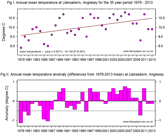
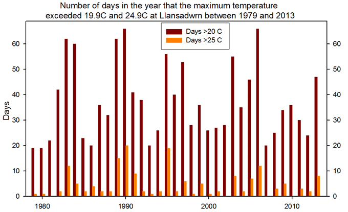
At Gorwel Heights the mean temperature was 8.3C; the mean maximum 10.7C and mean minimum 5.9C. The highest maximum was 16.9C in a Föhn wind on the 11th, that occurred after midnight on the 12th, when the relative humidity fell to a low 23% (see Diary). Ice precipitation fell on 11 days (+2.2) including large hail 7 mm on the 19th and 4 of snow pellets. Sleet or snow fell on 3 days and thunder was heard on 2 days, the 19th and 21st. Large 10 mm hail also fell at Gorwel Heights on the 24th, with a flash of lightning, covering the ground (see Diary). December followed the run of 4 consecutive dull months at Valley. The 34.7h of sunshine (74%) & [73%] K&Z adjusted, was lowest since 2011 and ranked 17th lowest on the Anglesey record since 1931. The sunniest day was on the 4th with 5.3h; there were 7 sunless days. ... Annual 2013Dry and sunny at the beginning, a cold spring and a warmer summer, record day's rainfall in August, dull autumn and a wet and warm beginning to winter
Monthly data 2013
Llanfairfechan observations
AcknowledgementsThe Met Office at RAF Valley kindly supplied observational data from 1942 to 2011. Current data (provisional) are gathered from SYNOP reports and METAR. I am grateful to David Lee for use of data from Gorddinog and deputy observers Fran and Evan Hennessey for help making observations through the year.
| |||||||||||||||||||||||||||||||||||||||||||||||||||||||||||||||||||||||||||||||||||||||||||||||||||||||||||||||||||||||||||||||||||||||||||||||||||||||||||||||||||||||||||||||||||||||||||||||||||||||||||||||||||||||||||||||||||||||||||||||||||||||||||||||||||||||||||||||||||||||||||||||||||||||||||||||||||||||||||||||||||||||||||||||||||||||||||||||||||||||||||||||||||||||||||||||||||||||||||||||||||||||||||||||||||||||||||||||||||||||||||||||||||||||||||||||||||||||||||||||||||||||||||||||||||||||||||||||||||||||||||||||||||||||||||||||||||||||||||||||||||||||||||||||||||||||||||||||||||||||||||||||||||||||||||||||||||||||||||||||||||||||||||||||||||||||||||||||||||||||||||||||||||||||||||||||||||||||||||||||||||||||||||||||||||||||||||||||||||||||||||||||||||||||||||||||||||||||||||||||||||||||||||||||||||||||||||||||||||||||||||||||||||||||||||||||||||||||||||||||||||||||||||||||||||||||||||||||||||||||||||||||||||||||||||||||||||||||||||||||||||||||||||||||||||||||||||||||||||||||



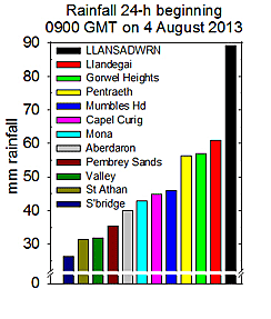 Rainfall on the 4th was 89.2 mm (16 wet hours) and was the largest recorded since the station began in 1979, beating August's previous largest fall of 41.0 mm on 14 August 2007. Also exceeding the previous record 86.0 mm on 22 October 2004. Llansadwrn records go back to 1928 and a fall of 137 mm was recorded in 3-h during a thunderstorm on 10 August 1957. The month's total was 136.6 mm (152%) & [157%] largest since 2004 ranking 11th on the Llansadwrn record. There were 68 wet hours duration.