Llansadwrn (Anglesey) Weather:
Snowdonia Snowline Report

 | Llansadwrn (Anglesey) Weather: |

|


|
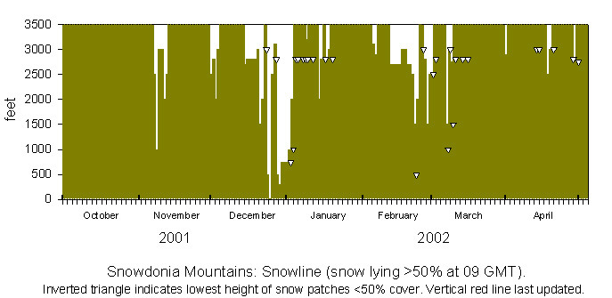
There was slight snow lying at 2000 ft, the first of the winter, on the morning of the 8th November 2001. Further snow fell on 12/13 November but sadly had melted by the afternoon of the 14th. There was a sprinkling of snow on the 1 December that was lying on the 2nd and further wet snow on the 3/4th that rapidly melted. On the 14th there was what I think was a heavy covering of frost, that looked like snow, above 3000 ft on Snowdon and the Carneddau. But snow did fall on the 16th and was lying thinly above 2800 ft on the 17-19th with temperatures on the on the summits just below freezing. Further wintry showers including snow fell on the 21st and by the morning of the 22nd was lying, with slight to moderate accumulations in places above 2800 ft, down to 1500 ft. There was a sprinkling as low as 1000 ft at Ogwen Cottage and Cwm Idwal. Further overnight snow on the 24/25th brought a white Christmas scene as low as 500 ft. Further snow on the 25/26th brought snow down to almost sea level at Pentraeth beach on Anglesey, but warmer air led to rapid a thaw so that by the morning of the 28th only patchy snow above 2800 ft remained on the Carneddau with some lying snow on parts of Snowdon. There were further wintry showers on the summits during the day and overnight 28/29th and 29/30th that brought a light covering of snow pellets and snow down to 300 feet in places on the morning of the 30th. During this colder spell temperatures, reported by the Snowdon summit AWS, had been below freezing with small amounts of snow accumulating on the summits.
The snowline on the morning of the 3rd January was about 1000 ft with patches as low as 750 ft in places but amounts at lower levels were small and disappeared during the day. On the 4th snow was seen at 2000 ft and was lower 1000 ft in shaded places such as Cwm Idwal but, with higher temperatures even on the summits, soon thawed leaving only some patches. Return of colder temperatures on the 8th brought a few light snow showers to the summits especially to Yr Wyddfa. After a warmer spell the weather turned colder again, fresh snow fell on the 15th and was lying as low as 2000 feet in Cwm Idwal and elsewhere, but again this soon retreated with the onset of more mild weather. There were sprinklings of snow on some summits around the 18th but it kept mild with no further falls until the 24th when there were light falls as low as 2000 feet during the day. With the return of very mild weather all snow, including gully patches, soon thawed. During intermittent colder spells there was a little snow on the summits on the 6-7th and a dusting on Snowdon on 13-14th February. Further light snowfalls then kept the highest peaks intermittently covered with a little snow. There was further fresh snow seen in the morning on the 21st at 2700 feet and there was more during the day. With the weather returning colder there were frequent wintry showers on the 22nd and in the night 22/23rd led to slight deposits as low as 500 feet in places and 1000 feet at Ogwen Cottage on the 23rd. Snow preceded heavy warm rain on the 24th that led to a rapid thaw of lying snow. Wintry weather returned on the 28th leaving a light covering of snow at 1500 ft with some at 1000 ft at Cwm Idwal. As with other snowfalls this season amounts were small and it had thawed by the 3rd of March in the next warmer spell. Another cold plunge came southwards on the 8th and resulted in wet snow generally at 1500 feet and it was as low as 1000 feet at the head of the Ogwen. The col between Carnedd Llewelyn and Carnedd Dafydd had accumulated some moderate snow by the 10th but the weather did not stay cold enough for it to last and, by the 12th, it was once again sparse. There were small patches remaining on N-facing slopes and gullies above 2800 feet until the 19th but these had all disappeared by the 26th.
The beginning of April saw lower temperatures on the 2nd and there was a sprinkling of snow on the highest summits in the morning but only lasted a few hours. More snow fell on the 19th and lay as low as 2500 ft, but only small patches were left on the 21st. Colder weather returned on the 28th with snow at 2500 ft and 2800 ft on the 29th. A little snow seen above Cwm Idwal on the 1st May was the last of the season.

|
Click on icons below for pop up graphic but please close each after viewing.
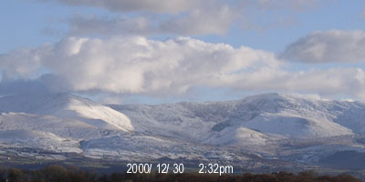
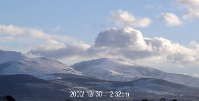
![]() Panoramic view of Snowdonia under snow taken from Llansadwrn on 28th December 2000.
Panoramic view of Snowdonia under snow taken from Llansadwrn on 28th December 2000.
![]() Panoramic view across Anglesey, towards Pentraeth and Red Wharf Bay, under snow taken from Llansadwrn on 28th December 2000. There is shallow inversion fog (note tops of trees) in the middle-ground.
Panoramic view across Anglesey, towards Pentraeth and Red Wharf Bay, under snow taken from Llansadwrn on 28th December 2000. There is shallow inversion fog (note tops of trees) in the middle-ground.
![]() Snowdonia snowline: Winter 2000-2001
Snowdonia snowline: Winter 2000-2001
![]() Snowdonia snowline: Winter 1999-2000
Snowdonia snowline: Winter 1999-2000
Observations were made as near to 0900 GMT as possible. I have a good view from Llansadwrn, weather permitting, across the Menai Strait, towards the Snowdonia Mountains. I can see the northern slopes of the mountain range from Moel Eilio (west of Snowdon), Snowdon summits (Yr Wyddfa and Crib Goch), the Carneddau and to Foel-fras and Drum on the eastern end near the Conwy Valley. With the aid of binoculars I make records of the lowest altitude of snow lying (>50% cover) and any patchy cover (<50%). .
Document dated: 12 May 2002. This page is maintained at http://www.llansadwrn-wx.co.uk
©: 1999-02 Donald Perkins