
|
|
Llansadwrn (Anglesey) Weather
|
1st: The year started showery and with rain in the evening and night accumulating 16.1 mm by the next morning. It was windy with a S-SE'ly gale later in the day and extending after 00 GMT. Valley, Anglesey recorded the maximum gust of the month of 68 mph on the 2nd.
2nd: Ice pellets fell in the early hours and later in the day. It was bright at times in the morning with showers in the afternoon, fresh snow could be seen on the mountains of Snowdonia down to 2500 ft.
3rd: With the wind in the N it was sunny at first. The wind turned to the SW and later S-SE'ly gale.
4th: The day started dry and bright but quite windy (SW force 6-7). It became cloudier in the afternoon with rain and gale force winds later.
5th: With warm S'ly winds there was moderate to heavy rain at times and becoming blustery in the afternoon. Rainfall was 31.2 mm, the most in a day in the month. Some local flooding of roads and fields. Screen temperature was above 11.0C between about 04 GMT and 24 GMT. The highest maximum temperature of 11.6C occurred shortly after 09 GMT.
6th: It remained very dull with slight rain at times. Little or no wind. Some roads and fields were still flooded with water running off higher ground.
7th: Rain at times with frequent showers containing ice pellets.
8th: Calm at first with light N-NE'ly breeze later. Became sunny. Fresh snow was seen to have fallen on the mainland mountains down to 2800 ft.
9th: Bright and sunny at first but soon cloudy with a shower of snow pellets about 1245 GMT. It cleared again in the afternoon and the night turned frosty.
10th: The lowest minimum temperature of the month (-1.7C) together with the lowest grass minimum (-6.3C) occurred around 05 GMT. It was sunny all day with a light and variable generally NE'ly breeze. The lowest maximum of the month 4.6C. Snow still visible on the mountains down to about 2300 ft.
11th: Good sunny spells all day, light NE'ly drift. Cloud to the W marking approaching front.
12th: Heavy rain commenced about 0230 GMT producing 22.5 mm in 6.0 hours, the second largest fall in the month. Became bright and sunny for a while later. Although the mountains remained partially obscured by cloud it was seen that only patchy snow remained after the rain
13th: A little rain at times clearing slowly by the afternoon.
14th: Bright and clear early but rain by mid morning. Moderate rain in the afternoon with strong to gale SW-W wind. Valley, Anglesey recorded a gust of 54 mph.
15th: Moderate to heavy rain with gale force winds. 19.3 mm in the 24h period.
16th: Soon sunny with a drying wind. The lowest RH (62%) of the month.
17th: Shower of ice pellets in the early hours. Blustery showers including more ice pellets clearing later.
18th: Rain at times, wind strong to gale by mid-day.
19th: Rain at first turning showery. Further rain later.
20th: Slow to brighten but the quite sunny in the afternoon.
21st: Hoar frost early. Sunny in the morning but clouded over by the afternoon with slight drizzle. Cleared to sunny later.
22nd: Hoar frost early, surface of soil frozen. Slight shower in the morning, sunny later before becoming cloudy in the evening.
23rd: Rain later, wind S-SW blustery at times.
24th: Dull but dry at first, rain later, wind to gale force by evening.
25th: Slight shower of ice pellets at 1203 GMT.
26th: Grass was dry at 09 GMT but soon wetted by a shower! More rain later with ice pellets at 1515 GMT. There was a shower of 6-8 mm hail at 2003 GMT.
27th: Bright at first but soon cloudy with drizzle later in afternoon.
28th: Slight rain or drizzle at first, cloudy but dry in the afternoon.
29th: Soon drizzle and light rain for a while. Increasingly foggy in the afternoon. Little or no wind. Thick fog by 1930 GMT causing small traffic accident on the road to Llansadwrn.
30th: Thick fog at 09 GMT gradually lifting by 1230 GMT. Somewhat brighter at first pm then murky with light drizzle before dusk.
31th: Calm at 09 GMT, dull but clear. Views of the mountains, the first for 3 days, showed snow patches on Carnedd Llewelyn.
Return to top of page
Return to home page
1st: Bright at first, cloudy mid-day then becoming sunny by afternoon. Dry.
2nd: Clear at dawn with a spectacular sunrise over the mountains of Snowdonia. Becoming cloudier by afternoon. Dry.
3rd: Remained cloudy and dull all day. Dry.
4th: Rain at first, becoming bright and sunny around mid-day when the temperature rose to 13.0C, the highest maximum of the month.
5th: Cloudy with frequent showers. Rain in the evening.
6th: Dull and very dark. Rain by the afternoon.
7th: At 0900 GMT a shower of snow pellets was followed by ice pellets then hail 7.5 mm diameter. snow at 0930 GMT. Further snow showers, heavy at 1140 GMT for 20 min. A little accumulated but soon melted.
8th: Slight sleet and snow at times, melting on deposition. Much snow on the mountains down to 500 ft and below in places. Shower of hail 7-9 mm diameter at 1950 GMT.
7th/8th Parts of western Anglesey, unusually, were reported to have up to 5 cm snow in places including the villages of Aberffraw, Bodorgan, Dywran, Gwalchmai and Gaerwen. Traffic on the A5 to the port of Holyhead was reported to have been disrupted for a time. The local 'Bangor and Anglesey Mail' of February 17th reported that the Traffic Inspection Team said: 'We had two or three difficult nights and one night in particular caused us some worry because cars couldn't move on the A5 towards Holyhead'. 'There were severe hailstones after the gritters had been, and they were finding it difficult to clear the roads'.
9th: Hailstones still on grass at 0900 GMT, overnight minimum -0.3C and -2.2 on the grass. snow flurry in the morning. RH of 60% about 1100 GMT was the lowest of the month. Sunny pm, a few cumulus clouds were over the mountains. Slight snow shower at 1630 GMT and snow pellets at 1727 GMT.
10th: Overnight minimum -0.5C, the lowest of the month; grass minimum -5.0C the lowest of the month. A sunny start to the day and at first in the afternoon. At 1700 a moderate shower of hail averaging 6.3 mm diameter lasted for 14 min and almost covered the ground. The leaves of bluebells, seen growing in our woodland nearby, were 5 to 5 cm tall! This is unusually early growth due to the mainly mild weather this winter.
11th: Remained cloudy and dull with fine drizzle am and at first pm. Some light rain later and becoming foggy.
12th: Earlier thick fog was thinning at 0900 GMT revealing the sky above. At 0910 GMT the tops of the Snowdonia mountains were becoming visible above dense inversion fog in the Menai Strait. Soon sunny with some cloud from time to time. Snow visible on the Carneddau mountains above 2000 ft but patchy in places.
14th: Continuous light rain turning to drizzle before dying out later. Murky. Evening damp with little or no wind.
15th: Increasing cloud with a few spots of rain am. Becoming bright with sunny intervals pm. Snow on the mountains only now seen in the N facing gullies.
16th: Sunny at first but patchy cloud later with 1 or 2 light showers pm. Cloudy at dusk.
17th: Fall of ice pellets early, becoming bright with a little sunshine. Soon cloudy with showers turning to light rain and increasingly foggy later pm.
18th: Dull, a little brighter later but remained overcast. Turned to rain and became windy later pm.
19th: Drizzle and mist at first, becoming brighter later especially pm. Visibility was good by dusk.
20th: Very hazy at 0900 GMT, bright under thin high cloud. Sun appeared through the cloud from time to time. Dry.
21st: Moderate showers and blustery at first. Soon brighter with a succession of quite active showers and strong gusts of wind pm. Shower of ice pellets at 1805 GMT and later in the day.
22nd: Frequent showers of ice pellets after 00 GMT. Sunny with strong NW wind and a few passing clouds. Clear views of the mountains of Snowdonia this morning enabling fresh snowfalls down to 1500 ft to be seen, and some cumulus clouds pm. Shower of ice pellets here at 1730.
23rd: Refrozen hail from the 22nd still on the grass at 0900 GMT. Snow at 2000 ft upwards still on the mountains. Sky clearing to being quite sunny but then turned cloudy with light rain or drizzle by 1500 GMT. Further rain later.
24th: Sunny morning with wind in the E-SE. Quite brilliant and clear. Clouds spilling over the mountains from the S, then quickly disappearing gave spectacular views across the Menai Strait, especially from Beaumaris, most of the day. Good view of the closest appearance of the planets Venus and Jupiter, in conjunction this year, in the western sky shortly after sunset.
25th: Dull but dry am. Spots of rain on the SW'ly wind later. Becoming very windy to gale force by evening. Fog at 2200 GMT.
26th: Gale continued for a time after 00 GMT but had decreased to force 4 by 0900 GMT. Bright and dry until about 1930 GMT when the station was on the edge of a heavy shower to the W.
27th: Sunny at first. Wind gusty at times to force 6 in the afternoon. Remained dry. Slight snow seen of the tops of the Carneddau mountains.
28th: Soon becoming SW gale force 8 and turning to rain later am. Rain and wind ceased later pm. The largest daily fall of rain (10.9 mm) in the month.
Return to top of page
Return to home page
1st: Dull with a shower am. A prolonged shower in the afternoon, misty. Moderate to heavy rain commenced about midnight. 20.6 mm rainfall by morning.
2nd: Continuous moderate rain and fog at 0900 GMT. The field in front of our house is flooded in places for the first time this winter. Became blustery later but the rain ceased about 1630 GMT. In the period (0000-1630 GMT) the continuous rain amounted to 34.7 mm, an average of 2.1 mm per hour. The peacocks looked very miserable in the rain. Wind increased to gale force later in the day with further showers in the night. 22.1 mm rainfall by morning.The most rain in a day this month, also the highest minimum (8.5C).
3rd: A brighter day but showery. The peacocks were happier having been able to dry out between showers. The clouds cleared sufficiently in the afternoon to see that fresh snow had fallen on the Carneddau mountains on the mainland down to 2000 ft but the tops remained obscured.
4th: A shower of ice pellets at 0720 GMT. The snow on the mountains was down to 500 ft at 09 GMT. During the morning there were frequent showers of rain mixed with ice pellets and sleet am. There was more prolonged rain in the afternoon with the N'ly wind increasing to force 6-7. The lowest maximum (4.5C) of the month.
5th: Bright and clear with sunny spells am. The very good visibility and high cloud base enabled spectacular view of the mountains covered with snow, almost end to end. The snowline was at about 1000 ft and lower in the Nant Ffrancon Pass. During the afternoon there were showers of snow pellets at 1642 and 1738 GMT followed by ice pellets then conical shaped hail at 1918 GMT (average 8.1 mm diameter). There were further showers of ice pellets during the night.
6th: It was bright and sunny at first. Fresh snow had fallen down to 500 ft on the western hills and mountains, and on Snowdon. It was cloudier in the afternoon with slight rain turning to drizzle later. There was rain after 2300 GMT until morning.
7th: Continuous slight rain and sleet at times falling as snow on the mountains. It was generally murky with further light rain in the afternoon but it cleared in the evening.
8th: An E'ly breeze today. Dull with only a little brightness at times am. Slight rain in the afternoon soon dying out but it remained cloudy.
9th: Mainly cloudy with a few bright or sunny spells. A cold NE wind. Drizzle at times later in the afternoon. Cloud base on the mountains hovered around the snowline at 1500 ft. Leaves of bluebells in woodland are now 12-15 cm and buds on sycamore and horse chestnut trees are about to burst open.
10th: There was a heavy deposition of dew, which had frozen earlier and melted by 09 GMT. Quite sunny today with little or no wind. The peacocks search out the most sheltered and sunny parts of the garden. Clear sky at 2200 GMT giving the possibility of a frosty night.
11th: The day dawned frosty, clear and sunny. There was a touch of air frost (-0.9C) and a moderate ground frost (-5.4C), both the lowest for the month. Frozen deposits were still on the grass at 09 GMT. The peacocks seem not to mind frosty weather except their feet seem to get cold. They prefer to stand on ericaceous (heather) plants, which insulate their feet from the frozen ground. Cloudier by noon with a little light rain or drizzle later.
12th: With clearing sky the day soon became sunny with only a little cloud. There was a freshening S-SW wind (from force 1 to 3). Cloudier later but remained dry. Sky clearing again later.
13th: With the wind remaining S-SW'ly, and some cloud earlier, there was little over night drop in temperatures compared with the 11th. Generally sunny and as the grass had dried by the afternoon I was able to mow the lawns.
14th: Becoming cloudier after dawn but there were good sunny spells during the day and it remained dry. Despite no further snowfall, the snowline on the mainland mountains is continuing at about 2000 ft.
15th: Much cirrus and lower patchy clouds with sunny spells in the morning. There was a slight shower around 1400 GMT, later with thickening cirrus sunshine was weak. It is often warmer, however, under cirrus cloud. The maximum temperature here today was 12.5C, the highest so far this month. The mountain snow was seen to be melting during the day. The ground has now dried considerably and ploughing has been able to start in nearby fields. This is the first cultivation activity seen this spring since the prolonged period of waterlogged soils.
16th: With clearing sky the day was sunny and breezy from the SW. It was warmer, the maximum reaching 15.5C during the afternoon. It was warm enough for many honeybees to be seeking pollen from our extensive heather beds. A local bee keeper has hives within 200 m of our garden, different varieties of heather are in bloom nearly all the year round and the bees take full advantage.
17th: Early fog was thinning at observation time and the day soon became sunny and warm reaching 16.9C, the highest for the month. Visibility was good in the afternoon and it was seen that the mountain snow cover was <50% and in patches in gullies on the Carneddau and Black Ladders (Ysgolion Duon). There appeared very little on the north facing slopes of Snowdon. Fog remained around Holyhead (Max only 12C), Colwyn Bay (Max 11C) and the Isle of Man (Max 10C).
18th: Slight shower in the night. Sky clearing, but only moderate visibility, to be quite sunny. A fairly stiff cold N-NW'ly wind but sheltered in parts of the garden, maximum only 11.8C.
19th: Mainly cloudy but with some sunny spells during the day.
20th: Bright at times in the morning. Dull and dry in the afternoon but it rained in the night.
21st: Bright for a while then a band of showers clearing by the afternoon. Strong NW wind.
22nd: Remained overcast with some rain in the afternoon. Misty.
23rd: Misty at first, brightened a little later in the morning only to be come overcast again in the afternoon.
24th: Slight rain early and further spots of rain and drizzle in the morning. Intermittent light rain from about 1600 GMT resulting in 7.2 mm over 9.2 hours.
25th: Very poor visibility with intermittent slight rain during the day clearing with a light N'ly wind later.
26th: A cold night with a ground frost (-2.3C). Frozen dew had melted by 09 GMT. It was sunny with good visibility and fresh snow had fallen on the mountains down to 2750 Ft on the Carneddau.
27th: With clearing sky there was weak sunshine at first. snowline on the mountains similar to yesterday (2800 ft). Heard the first chiffchaff of the season singing in the garden. The first bluebells are starting to show flowerbuds. Cloudier in the afternoon but there was clear sky over Liverpool Bay. The cloud lifted from the mountains about 1600 GMT and most of the snow had melted during the day.
28th: Weakly sunny at first as much cirrus as well as lower rapidly passing clouds in the moderate S wind. Cloud was piling up to the south of the mountains of Snowdonia. There were very slight showers in the afternoon. Increasingly windy later, strong to gale from the S. The male peacock was unable to go to roost in his usual tree. In strong winds at this time of year, when his tail is fully developed, he has flight problems. He must have gone to ground at dusk somewhere else.
29th: Overnight there was 11.2 mm of rain. The rain soon died out and the day became bright and sunny. There was a brisk SW wind.
30th: With the sky clearing it soon became sunny. Cumulus clouds were seen building over the mountains. It was sunnier and clearer in the afternoon. The maximum here today was 14.0C but further along the North Wales coast at Hawarden 17C was recorded. Colwyn Bay had 16C and Valley on Anglesey 12C. The first celandine and campion flowers have appeared in the woodland and patches of wild garlic are now quite prominent. In the garden several violets and the first rhododendrons and azaleas are in bloom.
31st: It was mainly cloudy with a slight shower in the morning. The afternoon was quite sunny through thin cloud, with the wind a light S-SW'ly, when the maximum reached 15.6 C. Valley recorded 15C but, at another COL station at Red Wharf Bay 4 km N of here, there was a maximum of 17.8C in a SE'ly breeze off the mountains. Colwyn Bay also recorded 18C.
Return to top of page
Return to home page
1st: There was a red sky as the sun rose from behind the mountains at 0615 GMT. With a thin cloud cover and only a light SE'ly breeze the temperature reached 19.6C (the highest maximum of the month) and a low relative humidity of 49% during the afternoon. Valley, Anglesey recorded 20C and Red Wharf Bay 20.2C. Colwyn Bay recorded 19C. There was a shower of rain in the night. The Piche evaporimeter recorded 2.8 mls of evaporation, the most in a day in the month.
2nd: It was hazy but sunny at first but became cloudier later with slight rain in the afternoon.
3rd: The day began calm and sunny and had reached 15.8C by noon. In hazy sunshine a maximum of 17.5C was reached early in the afternoon before becoming cloudier. The primroses in the garden are prolific this year and are at their best at the moment. Greenfinches sometimes nip off the flowers and discard them on the ground. The reason for this seems obscure and some in some years the damage is considerable. So far this year there is only slight damage.
4th: It was murky at first with fine drizzle. This soon ceased and a gradual improvement becoming bright with sunny spells in the afternoon. There were showers in sight, however, and there was a period of light rain from about 1830 GMT.
5th: It was misty at first with some light rain in the morning. There was a little brightness and breaks in the cloud later with the S'ly wind increasing to force 6-7. There was rain in the night.
6th: The day began sunny with patchy cirrus and some lower cloud here and on the summits of the mainland mountains. The wind was a force 6 SW'ly, the peacocks were preening in a sunny sheltered garden border. It became quite blustery later in the morning and there was some thundery rain in the afternoon. Thunder was not heard here but there was some activity in the Irish Sea off Holyhead and near Barmouth in Gwynedd. There are now several bluebells in flower in the wood.
7th: There was low cloud and mist over the mountains at first but this was clearing somewhat by 09 GMT. Further clearance took place later and it became sunny in the afternoon. The wind was W-NW'ly and this tended to keep some cloud on the mountaintops all day. Blackthorn and gorse are now in full flower in the hedgerows. Hawthorn is coming in to leaf but this will flower later. The gorse is particularly good on the banks of cuttings either side of the Britannia Bridge.
8th: The day dawned dull and misty with moderate fog at 0630 GMT. This has thinned a bit by 09 GMT but visibility was still very poor and the sky obscured. It became brighter by noon as a weakening front passed by and it cleared to become sunny at the end of the afternoon.
9th: Another dull and misty start to the day, the temperature at 09 GMT (10.3C) was the highest minimum of the month. There were signs of it clearing by noon. It was quite sunny in the afternoon until about 16 GMT with the wind increasing to SW force 4/5. There was moderate/heavy rain between 0130-0400 GMT.
10th: There were showers at first but sunny spells developed in the morning. There was more sunshine in the afternoon and the cloud lifted from the mountains. No rainfall today.
11th: An almost clear sky at dawn, with just a few cumulus clouds over Snowdonia, but cloudier by 09 GMT. It became windier during the afternoon, SW-W force 6-7 circulating around a low to the NW of Scotland. In the evening the wind had increased to gale force with moderate to heavy rain at times. 14.6 mm rainfall had accumulated by morning giving the wettest day of the month.
12th: It was raining slightly at 09 GMT and the soil was waterlogged once again. The ground was also littered with torn and shredded leaves from the earlier leafing trees (sycamore and horse chestnut) the result of yesterday's gale. It was brighter later as the wind went to the NW. There was a short heavy shower at 1512 GMT but the thundery outbreaks down the spine of England did not occur here. By evening the wind was N-NW'ly and was colder.
13th: There was sleet at first and frequent showers of snow pellets and ice pellets. There was a shower of conical shaped hail (7.5 mm diameter) at 0730 GMT and a moderate fall at 1015 GMT (6.6 mm diameter again conical shaped). There were sunny spells but the wind increased to force 6/7 NNW'ly and gale force at times. There was a further band of showers, a mixture of rain, ice pellets and sleet during the afternoon but cleared between 15 and 16 GMT. The showers had fallen as snow over the mountaintops. There was a clear sky at 21 GMT and with the grass minimum already below 0C.
14th: The day dawned to reveal a covering of snow and snow pellets which has rolled off the roof and formed a pile 60 cm deep at our front door under the valley between the SW and NW gables of the house. Snow was heavy for a time from about 04 GMT and, when melted, was equivalent to 6 mm rainfall. At 09 GMT there was 2.3 cm of level snow lying with a night minimum of -0.5C and a grass minimum of -4.5C, both the lowest of the month. It was a sunny morning and most had melted by 1200 GMT. There were further snow and snow pellet showers in the afternoon, before becoming sunny again, and then further snow in the evening but it did not accumulate.
15th: There was a moderate fall of ice pellets at 0645 GMT and showers of rain and sleet later in the morning. The lowest maximum of the month of 8.7C. The snowline on the mountains at 09 GMT was about 800 ft. After further rain showers in the afternoon it cleared to be a sunny end to the day and with lessening wind the prospect of a frosty night.
16th: It was a sunny, albeit weak through cirrus cloud, start to the day with very good visibility. Snow was still around 800 ft on the mountains. A greater spotted woodpecker was drumming in the wood. Also in the wood ferns are beginning to unfurl their pale green fronds. The afternoon was cloudier with a slow moving shower.
17th: There were sunny spells at first with cumulus clouds towering over the mountains but they dispersed during the afternoon, which was clear and sunny. There were goods views of the mountains with the rocky cliffs showing up well against the bright white snow. The snowline had retreated to about 1200 ft but was lower in the Nant Ffrancon pass at Ogwen Cottage near Cwm Idwal.
18th: Occasional bright or sunny spells in the morning becoming sunnier with very good visibility later. The recent frost and snow has damaged some of flowers on the dwarf rhododendrons in the garden. Earlier flowering types have already flowered and are past their best, and we still have most of the later flowering types yet to appear. Since the 11th the ground has been very wet and has brought cultivation in the fields, and garden, to a temporary stop. The earliest sown fields of barley have germinated and showing leaves about 5 cm tall, while most ploughing has finished many fields have still to be harrowed and sown. A day without further rainfall was very welcome.
19th: An almost clear sky at dawn brought a frosty but sunny start to the day. There was extensive hoarfrost with the grass minimum reading -2.5C but no air frost (lowest 0.9C). By 09 GMT there was one small cloud over the mountains and some low on the western horizon. Around noon the relative humidity had dropped to 45%, the lowest of the month. The Piche evaporimeter recorded 2.1 mls of evaporation over the 24-hour period. It had become overcast by 1600 GMT and there was rain 2300 GMT for 5.5 h.
20th: It was dull with slight intermittent rain throughout the day with a period of moderate rain (6.7 mm in 2 h from 1500 GMT). There was further intermittent rain later in the night, the total for the 24-hours was 8.6 mm.
21st: It was still raining slightly at 09 GMT and continued until about 1730 GMT. With the barometer reading hovering around 980 mb it became windier throughout the day (around a low of 972 mb over N. Ireland), becoming strong to gale during the afternoon. For the second time this month many newly emerged leaves on the sycamores and horse chestnuts were shredded and stripped from the trees.
22nd: Quite an improvement in the weather today, after a slight shower at 09 GMT it became sunny especially in the afternoon. It remained windy with a force 6 SW'ly. There were some cumulus clouds over the western Snowdonia mountains in the afternoon and a shower here around midnight.
23rd: After a slight shower it became quite sunny. There were some cumulus clouds building and dispersing from time to time. The rain moving from the south, along the spine of England and the borders, did not affect here. The afternoon became very clear with very good visibility. The Isle of Man was the sunniest place in the UK with 12.1 h sunshine, Anglesey was not far short with 10.5 h. The maximum temperature here was 14.0C along with Colwyn Bay 14C.
24th: It was mostly cloudy in the morning but it did brighten up in the afternoon when a maximum of 14.2C occurred in the best sunshine of the day. The surface soil on our garden plot is beginning to dry and with soil temperatures around 10C it is time to start planting our vegetable seeds.
25th: It was murky today with slight rain or drizzle, which continued into the evening (2.7 mm over 8.1 h).
26th: Again very murky, sky obscured at 09 GMT. Slight rain at times and one period of heavier rain later. It became somewhat brighter late in the afternoon.
27th: A sunny start to the day and it continued into the afternoon but was increasingly windy, force 5-6, before ceasing in the evening. Quite warm, maximum 17.1C and no rainfall.
28th: Another sunny day. The only clouds were formed from 5 condensation trails of aircraft moving in a SSW'ly direction and forming wispy cirrus. The highest pressure of the month, 1032 mb. Signs of the surface soil drying throughout the day. Maximum temperature of 18.2C and Valley recorded 13.5 h sunshine.
29th: The third consecutive sunny day with Valley recording 13.4 h sunshine. Maximum temperature of 17.7C. Became quite hazy later in the day with the pressure dropping.
30th: It was cloudy and dull at first due to the passage, southwards, of a weakening cold front. It soon brightened and became sunny before noon with 10.7 h sunshine at Valley.
Return to top of page
Return to home page
1st: A cloudy start but this soon dispersed to give a mostly sunny day. There was a cool N'ly breeze which moderated the temperature with a maximum of 13.5C. The night minimum of 5.0C was the coolest of the month.
2nd: Dull and murky at first but was brighter just before noon when the cloud began to thin. The afternoon saw a continued improvement to mainly sunny with a very light variable breeze from the SSW-SSE. The maximum reached 18.8C about 1600 GMT. At Red Wharf Bay just 4 km N of here the wind was a N-NE'ly off the sea and the maximum was only 13.8C. The mountains remained obscured by cloud all day.
3rd: At dawn the sky was almost clear of cloud and was to remain so all day. At 09 GMT it was hazy and there was a light SE'ly breeze off the mountains which usually indicates a warm day to come. A light sea breeze from the NE set in intermittently in the afternoon. The maximum was 20.0C and Valley (Anglesey) recorded 13.9 h of sunshine, the highest reported in the UK.
4th: Again sunny and warm in the morning the temperature reached 20.5C before noon. There were cumulus clouds building up over the mountains and, although sunny at first in the afternoon, it became cloudier later but it remained bright with the sun visible through thin cloud. The maximum reached was 21.2C, the highest of the year so far. This was the eighth day without rainfall. The peacock has been roosting in an exposed tall tree favoured in settled weather, he never seems to roosts there in unsettled weather.
5th: Another sunny morning but there was a lot of thin high cloud which was persistent throughout the day. It was very hazy all day and there was a shower of rain between 21-22 GMT, the first for 9 days.
6th: Thin patchy cloud at first becoming very murky. Some spots of fine rain in the morning. Clouds in the afternoon were dark and threatening, a few more spots of rain and a shower interrupted lawn mowing, signs of it clearing towards evening.
7th: It was raining slightly with mist over the mountains at first. Intermittent rain continued through the day with the occasional break in the clouds giving a glimpse of the sun. 8.1 mm rain in the 24-h period and a maximum of 17.0C.
8th: It was showery at first with a blustery SW'ly wind and then became bright with a few sunny intervals. It was windier in the afternoon and a spell of drizzle and light rain began about 15 GMT. 7.7 mm rain in the day.
9th: It was dull at first with a slight shower in the morning. It was bright at first in the afternoon before becoming cloudier with drizzle or slight rain around 15 GMT. Almost a repeat of yesterday but the rainfall was less, only 0.5 mm.
10th: Showery at first with a blustery SW'ly wind. It was very dark and threatening to the NW but showers here were only light during the day. There were heavy showers in the night and 8.3 mm had fallen by morning.
11th: There was intermittent rain at first becoming showery with sunny periods in the morning. Somewhat sunnier and dry in the afternoon. Further shower in the evening.
12th: There was a shower early and the morning was blustery with a SW'ly wind force 5. The afternoon was quite sunny but it remained windy. There was a shower in the evening and more in the night. There was thunder in the east of Ireland and England around 15-16 GMT but none was heard here. Most trees in the area are now in full leaf except some late emerging types of sycamore and ash. Hawthorn in the hedgerows is now in flower.
13th: The showery pattern of weather continued with showers and sunny spells in the day. It became more overcast later with slight rain or drizzle in the evening followed by a period of moderate rain around 22-23 GMT. 11.9 mm of rain had accumulated by morning the largest 24-hour fall in the month. Some of the first Anglesey grown potatoes were on sale today at 50p per lb. They are 2-3 weeks later this year because the ground was waterlogged earlier and this had prevented planting the seed.
14th: At first the sky was obscured by fog (low cloud) though the sun was just visible from time to time. It became clearer later in the morning and the rapidly in the afternoon when it was sunny. The wind light was from the NE. At 1715 GMT the mountains were clearer but a band of cloud extended from Conwy in the E to Snowdon in the W where it was dispersing. At Conwy the mountaintops were in the cloud but at Snowdon (though higher) the cloud base was well above the summit.
15th: Patchy cloud at first was dispersing by 09 GMT giving a sunny morning. The maximum was 16.0C about 1600 GMT. The wind was light NE'ly. In the afternoon some cloud was developing for a while and moving from the SW to here where it was dispersing. The surface wind remained NE'ly. This happens quite frequently here where the wind off the sea to the NE opposes a S'ly airflow from the mountains. The cloud retreated to the W in the evening when it became calm.
16th: At dawn it was cloudy but had begun to clear by 09 GMT. It was sunny for a while in the morning and a little cumulus formed over the mountains just after noon but soon dispersed. The afternoon was almost cloudless with Valley (Anglesey) reporting 12.5 h sunshine. The Isle of Man with 14.5 h was the sunniest place reported with Jersey having 14.1 h. Manchester had only 0.1 h.
17th: It was becoming cloudier before 09 GMT but remained bright with a few glimpses of the sun. At noon the maximum was only 11.6C and the afternoon remained generally cloudy and the maximum struggled to reach 12.8C. Valley (Anglesey) recorded 13.3 h of sunshine certainly more than here and at Colwyn Bay just along the mainland coast (1.7 h). Shetland had the most sunshine in the UK with 15.0 h.
18th: Pressure was dropping as a low from the Mediterranean was expected to move up through France to affect southern Britain today. It was dull in the morning but in the afternoon it became sunny for a while and the temperature rose to 18.3C. There was an E-SE'ly wind force 5 but this decreased to force 2 by 1600 GMT. It became cloudier again in the evening.
19th: A bright start to the day but visibility was poor in thick haze. The day remained mostly cloudy with fleeting sunny spells. Later in the afternoon there were black threatening thundery clouds to the S but no storm developed. Thunder storms were occurring all over France with some along the south coast of England. A consignment of roofing slates was today being sent from Penrhyn Quarry at Bethesda at the foot of the Nant Ffrancon Pass in Gwynedd to Sydney, Australia. A hailstorm, which it was reported damaged 20,000 houses last month (April), led to orders being placed for 600,000 Penrhyn Heather Blue Capital and County Natural roofing slates. A quarry spokesperson was reported in the local weekly Mail as saying the order "...demonstrates the strong relationship we have built with Australia over the 200 years since Penrhyn first began despatching natural slates there". Penrhyn Quarry employs 239 people.
20th: There was mist lying across the nearby fields at dawn, but with an almost clear sky it was soon dispersed in the sunshine. It was a warm and sunny morning with only a light variable wind. It was cloudier towards noon but this dispersed to give a sunny afternoon and evening. The maximum for the day was 18.6C.
21st: There was a period of rain from 05-08 GMT amounting to 2.4 mm. The slight rain turned to drizzle by 09 GMT and the visibility was very poor. There was a blustery SW'ly wind force 6 with drizzle at times which continued into the afternoon. There was no measurable amount of rain for the day. It was brighter later in the afternoon with the wind moderating and by evening it was clearer and sunny.
22nd: A sunny start to the day with the wind in the W. It remained windy (force 5) and became cloudier by the afternoon with a freshening SW-W wind (force 6). There was a slight shower in the evening.
23rd: It was dull with spots of rain on the wind at 09 GMT. It remained dull and windy in the morning the cloud only thinning somewhat in the afternoon. There were a few fleeting glimpses of the sun and it continued blustery.
24th: There was 2.5 h of rain from about 07 GMT amounting to 2.3 mm credited to the 23rd. It was becoming brighter, with a sunny spell, before noon followed by a moderate shower. This station was on the edge of a heavy shower, which affected Llanbedrgoch, a village to the N of here, causing the road to the Post Office to be flooded. Later in the afternoon it became sunny again.
25th: It was becoming cloudier by 09 GMT when the sky was 7 oktas covered. There had been sufficient cloud clearance for the grass minimum to drop to 2.2C, the lowest of the month. This was, however, the highest recorded in May at this station. The morning remained bright but it became windier. The afternoon was quite sunny for a while before becoming cloudier again. There was no rain during daylight hours. Maximum temperature here was 14.0C and similar at Red Wharf Bay 14.4C. It was sunnier at Colwyn Bay (9.3 h compared with Valley 5.9 h) where the temperature reached 17C.
26th: There was drizzle and fog early in the day, which had thinned by 09 GMT when visibility was still poor. Cloud persisted until late afternoon when it began to disperse. It cleared sooner on the coast at Red Wharf Bay where the temperature rose to 16.4C. Here the daytime maximum was 14.8C but the maximum for the 24-hours (16.5C) was at 09 GMT on the 27th.
27th: A warm sunny morning with little or no wind. Most cloud cover was cirrus overhead with some patchy cloud low to the W. The cirrus thinned somewhat towards noon but it became hazier and cloudier later. There was a light cool NE breeze off the sea but a S'ly breeze took over later in the afternoon. The temperature rose to 22.8C becoming the warmest of the month and, exceeding the 21.2C on the 4th, becomes the warmest of the year so far. Nearer the coast at Pentraeth the sea breeze persisted and the maximum was only 19.0C. Colwyn Bay recorded 23C with 11.9 h of sunshine. The evening was sunny at first but dark clouds were pushing in from the SW at dusk. There were extensive thunderstorms over South Wales in the evening which disrupted the electricity supply to many homes.
28th: There was a roll of thunder at 0120 GMT and some moderate rain for a while (8.1 mm) with a further rumble of more distant thunder later as the thundery low tracked northeastwards largely missing Anglesey. It was a warm night with the minimum of 13.3C occurring at 09 GMT. This was the warmest night of the month and the highest in May in my records back to 1979. The forecast had been for a sunny day, but it was very dull and misty with intermittent drizzle or light rain during the morning. The afternoon remained similarly dull and sunless. It became increasingly windier with S-SW force 6-7 gusting force 8 at times. The wind dropped later but it remained misty.
29th: There was drizzle early and it again remained dull and sunless throughout the day until near sunset at 2015 GMT. A fleeting appearance of the sun very low in the sky, and a local shower, produced a most brilliant rainbow to the SE. There was a complete arc and a partial secondary arc. The colours were very strong and lasted for 12-15 minutes. The lowest maximum temperature (11.3C) of the month.
30th: Again dull and mist with early drizzle. It continued to be overcast and sunless. A bright period occurred in the middle of the afternoon when the cloud thinned a little, but the cloud soon thickened again dashing hopes of some sunshine. There was sunshine N of here at Tiree 14.7h but at Valley 0.0h.
31st: The fourth successive sunless day (except 15 minutes on the 29th). Dull and mist at first with a little drizzle in the morning. Afternoon again overcast with a failed attempt at clearing about 1300GMT. The daytime maximum was 13.3C but the 24-hour maximum was 14.2C the current temperature at 09 GMT on the 1st June.
Return to top of page
Return to home page
1st: It was calm with poor visibility, but there were signs of the sky clearing at 09 GMT. Although there was a little sunshine from time to time there were periods of patchy cloud until the evening which was clearer. The maximum was 17.3 and at times it felt sultry. At 2015 GMT cumulus were building over the mountains on the mainland. Storms over France were moving into S England.
2nd: There was moderate to heavy rain from 05 GMT, which accumulated 13.3 mm by 09 GMT. The morning was very misty with slight rain or drizzle. There was some minor flooding on the road to Beaumaris. There was a shower of rain in the afternoon with visibility remaining very poor. There was further rain in the evening and night accumulating 13.5 mm over 11.1 h by morning. This month is already looking very similar to June 1997 and 1998 both of which were very wet.
3rd: Another cloudy day with a few breaks appearing from time to time. There was rain in the evening and more by morning when it was moderate to heavy accumulating 6.5 mm.
4th: At 09 GMT it was clearing with a brisk SW'ly wind which by noon had increased to force 6-7. Visibility had improved and the mountains could be seen for the first time in days. The afternoon remained windy but mainly sunny. There was a slight shower in the afternoon and a sunny evening but was turning colder.
5th: There were falls of ice pellets in rain just after midnight; the air temperature dropped to 6.3C and on the grass to 3.5C in the night. There was a sunny start to the day but became cloudier later. There were large cumulus clouds over the mountains at 09 GMT. It felt cool in a light N'ly breeze but was mainly sunny. The shower clouds dispersed and it became very clear with good views of the mountains in the evening sunshine.
6th: There was a little rain by the morning observations and another spell before noon. The day remained cloudy in a light NW'ly wind but Valley (Anglesey) had 5.7h and Colwyn Bay 5.5h sunshine.
7th: The sky was beginning to clear early in the day, with the clouds lifting from the mountains, and good sunny spells developed through the morning. There was a cool N'ly breeze and this kept the maximum at noon to 12.5C. In the afternoon there was almost clear sky for a while, except for some cumulus clouds over Snowdonia, with a maximum of only 13.0C. This was the lowest maximum of the month.
8th: The night was the coldest of the month with a minimum of 4.7C and 1.6C on the grass. The air was fairly dry (RH 73%) and there was very good visibility at 09 GMT. The afternoon was sunny, with the high cloud of the morning dispersing, giving a maximum of 16.0C. Relative humidity dropped to 48%, the lowest of the month. Visibility continued to be very good, in the dry clean air, enabling views of Yr Rifl (the Rivals Mountains) on the Lleyn peninsula and Ynys Enlli (Bardsey Island) to clearly be seen.
9th: It was very clear again first thing, there was some cloud high over Snowdonia and patches around the summits. It was a sunny morning then cloudier around noon and a slight but rather prolonged shower in the afternoon before brightening with sunny spells later. The evening was cloudy.
10th: A dull start to the day with cloud low over the mountains. Some brightness around 09 GMT failed to develop further and thick clouds made the morning seem quite dark. The cloud dispersed later in the afternoon giving a sunny end to the day.
11th: Another dull and dark morning with little or no wind. There were one or two bright spells in the afternoon.
12th: Slight rain at first but becoming sunny during the morning as the NW'ly wind strengthened to force 3. The afternoon was quite sunny except for some cirrus clouds for a time. There was a more or less clear sky in the evening and dew was forming on the grass before dusk.
13th: A sunny start to the day but soon it was cloudy and remained so most of the day. Valley (Anglesey) had 5.4h and Colwyn Bay 6.6h sunshine, it seemed much less than that here. Stations to the S had even more, Fishguard 10.0h and Penzance 14.0h.
14th: A slight shower just before 09 GMT but it soon became quite sunny with a maximum or 18.2C. It was windy a SW'ly force 4 increasing to force 5-6 by the afternoon. The afternoon was partially cloudy and the evening very cloudy.
15th: Dull at first but soon sunny and warm, maximum 19.0C. It was cloudy soon after noon but there was a sunny spell later before returning to cloudy conditions in the evening. Valley (Anglesey) had fog and only 0.4h sunshine whereas Colwyn Bay had 9.0h. Fishguard and Falmouth both also had fog.
16th: It was sunny and warm early in the day and this continued most of the day, maximum 19.5C. Visibility was very good with just a little cloud over the peaks of Snowdonia. Late evening was cloudier and there was a loss of clarity. The forecast had been for cloud and fog for western coastal areas so it was a surprise and quite a bonus.
17th: There was a period of rain in the night but it was clearing at 09 GMT to become a sunny morning although there was a lot of cirrus. The afternoon was also sunny but with moderate amounts of high cloud. The evening was sunny and with a clear sky the temperature was dropping rapidly by 20 GMT. Gardeners will know that temperature drops at this time of year can cause bud-drop on plants such as sweet peas (Lathyrus odoratus). So far this year the flower buds look secure although they have yet to open. Tomatoes can only be grown in glasshouses here; even so overnight temperature drops too can affect them. They were badly affected last year losing several trusses, this year I am keeping my heater switched on, and set to heat should the temperature drop below 12C in the night.
18th: The overnight minimum was 7.7C and 5.3C on the grass and it was sunny from dawn. There was a line of cumulus over Snowdonia by 10 GMT but these dispersed later. It remained sunny, with a maximum of 19.5C, until about 15 GMT when high clouds appeared from the W. It became hazy and rather murky as the cloud density increased. There was slight drizzle from about 1830 GMT.
19th: It was still cloudy first thing and the overnight minimum did not drop below 13.6C, the highest of the month. Although the sun could be seen behind cloud from time to time around 09 GMT it was its only appearance of the day. There spits and spots of rain at times during the day and rain from 1600 GMT in the afternoon and evening when it was moderate to heavy at times. The wind was SW'ly force 5-6 and gusted to force 7 occasionally as a cold front moved SE'wards. By morning 21.1 mm of rain had accumulated over 9.8 h, the largest fall of the month.
20th: It was bright first thing after the overnight rain, even one or two sunny intervals in the morning, but was cloudier around noon. There were some sunny spells in the afternoon but it remained mainly cloudy. In the evening the cloud dispersed and it became sunny. Evaporation has been high this month and the free draining soil of the vegetable plot had been looking rather dry on the surface despite earlier rainfall. The rain has benefited the crops but we could do with more sunshine.
21st: The cloudy weather still continues with only a glimpse of the sun until later in the day.
22nd: Mainly cloudy again in the NW'ly wind. Just a few sunny spells but the wind moved to the SW later before the start of a long period of rain (8.2 h) resulted in 9.8 mm by morning.
23rd: Cloud seemed to be lifting at 09 GMT and there was a glimpse of the sun. The murk soon returned with slight drizzle until late in the afternoon when there was a gradual improvement from the west. The sky cleared in the evening and it was sunny before nightfall. The temperature was dropping rapidly from a maximum of 17.7C during the day and mist was forming low across the fields at 21 GMT.
24th: A calm and sunny start to the day with low-lying mist still to be seen across the fields. When sunny it felt warm, but there was patchy cloud around noon. The sky cleared later in the afternoon to give a sunny end to the day. The day's maximum was 19.7C. The wild roses in the hedgerows are now in full flower. There are some quite spectacular stretches in places (eg on the left side of the A5025 to Pentraeth, just past the turn off to Llansadwrn) where the hedges have not been cut back too severely.
25th: A sunny start to the day and with a S'ly wind it felt quite warm and by 09 GMT was 19.2C with an RH of 67%. Hazy sunshine continued through the morning and the maximum of 23.0C was reached before noon. It continued warm in the afternoon although there was some patchy cloud for a time.
26th: Another sunny start to the day with a temperature of 19.5C at 09 GMT in a S'ly breeze. Later in the morning it became cloudier and there was a slight but prolonged shower which, when dried, left a deposit of pale yellow (Saharan) dust on horizontal surfaces. The afternoon was cloudy at first, then sunny for a while and the temperature rose to 24.5C the highest, of the month and of the year, so far. Distant thunder was heard at 1750 GMT and it continued until 1830 GMT when it started to rain. There were a few local lightning flashes at 1930 GMT accompanied by a short period of moderate to heavy rain (13.0 mm in 2 h). The storm, mainly over Snowdonia, was moving NE'wards and we only saw the edge of it here. By morning rainfall totalled 17.8 mm, over 12.4 h, and was the second largest fall of the month.
27th: Visibility was poor in slight drizzle in the morning. There was some unusual temperature readings at 09 GMT. The dry bulb in the screen was reading 11.6C after a recent minimum of 11.1C. The lowest recorded on the grass minimum was however 11.6C and when reset it read 12.5C. The soil temperature at 5 cm at the time was 16.0C and could have been warming the grass thermometer. It is fairly rare to record a grass minimum higher than the screen minimum.
28th: There were signs of the sky clearing at 09 GMT but there were some spots of rain at the time. There were some sunny spells later in the morning and early in the afternoon but soon became cloudier with a freshening wind, SW'ly force 5-6, and a further few spots of rain none enough to produce a measurable amount.
29th: There was an almost clear sky at 06 GMT with only one or two cumulus clouds peeping over the mountains to the S. There were good sunny spells at first but it became cloudier before noon, some looked black and threatening but no rain here. It became clearer later in the day. On the west coast of Anglesey at Aberffraw it was sunny from where the persistent cloud over SE Anglesey and the mountains could be seen. Valley in NW Anglesey was also in sunshine (10.7 h).
30th: It was overcast at 06 GMT but by 09 GMT there were signs of the sky clearing. The were sunny spells in the morning and afternoon before becoming cloudier with rain in the evening and night amounting to 8.3 mm over 7.3 h. This has been the third consecutive wet June (>100 mm), in Llansadwrn records since 1928, with a total of 101.3 mm. There was 182.9 mm in 1998 and 109.4 mm in 1997. Previously there have only been two sets of consecutive wet Junes (>100 mm), 1935-36 and 1965-66. In all there are now 15 Junes with >100 mm rainfall.
Return to top of page
Return to home page
1st: The overnight rain had ceased by about 07 GMT but there was fog and some drizzle before 09 GMT. The morning was murky but there were signs of the cloud lifting at noon. There was a little short-lived brightness later and a period of rain in the evening and night amounting to 2.4 mm. (Valley, Colwyn Bay and Fishguard 0.0 h sun)
2nd: There was fine drizzle early and at 09 GMT although overcast it was bright and warm. By noon there were breaks in the cloud and it became sunny and warm later in the afternoon with a maximum of 23.4C, only to become overcast again in the evening. By 1930 GMT it was very dark in thick cloud and it rained by 2100 GMT. A rumble of thunder was heard at 2124 GMT. On the BBC TV weather report lightning strikes were shown as occurring down the length of Wales, the storms moved eastwards into England later in the night. Valley, Ronaldsway (IoM), Fishguard and Penzance reported coastal fog.
3rd: Mostly cloudy with some bright and sunny intervals when it felt pleasantly warm but maximum only 18.5C. The SW wind was force 5-6 at times and there were the occasional spots of rain later in the day.
4th: It was overcast early but it was clearing by 09 GMT. There were a few sunny spells in the morning and it was sunny in the afternoon and less windy with a maximum of 21.0C.
5th: It was becoming cloudier at 09 GMT with black clouds appearing from the S. There was rain from 0955 which turned moderate to heavy for a short time (total 8.0mm most in less than an hour). At noon there were still some quite active looking clouds in the vicinity but it was sunny. The ground and vegetation was 'steaming' in the warmth (16.6C and 100% humidity). It is quite rare to see these conditions here. Although predominately cloudy at first the afternoon became sunny with a maximum of 20.5C. Towering cumulus clouds were seen to the SE over the mountains in the afternoon. There were storms and tornadoes reported from central England during the day.
6th: It was sunny first thing with some patchy high clouds. It became cloudier towards noon. It remained mostly cloudy in the afternoon but there were some bright and sunny intervals with a maximum of 22.5C. To the SW of here at Brynsiencyn it was sunny most of the day but on the west coast at Aberffraw sea fog spoiled the sunshine. Again in the afternoon towering cumulus were seen to the SE and further tornadoes were reported in the English Midlands.
7th: Although overcast visibility was very good at first. There were a few sunny intervals in the morning. By noon it had become hazy and the afternoon, though cloudy, was bright. The daytime maximum was 19.8C the absolute maximum of 20.3C occurred at 09 GMT on the 8th.
8th: It was sunny early with just a few patchy clouds. Air pressure (1033 mb) was at it highest of the month. The morning was sunny but there were a few clouds overhead at noon, which were forming and reforming. The wind here was S'ly and it is likely that the clouds were the result of the S'ly meeting a NE'ly sea breeze. It became cloudy here later 8/8th. From Llanbedrgoch, which was still sunny, the cloud over SE Anglesey forming a small sea breeze front could be seen with some mist around the coastal headlands from Red Wharf Bay towards Penmon. Later in the afternoon (15 GMT) the NE'ly sea breeze was felt and the cloud slowly cleared away to give a clear sky from about 17 GMT onwards. Maximum (around 13 GMT) was 24.3C. Today the first really large bunch of sweet peas was picked in the garden. There has been some bud-drop (see entry for 17 June 1999) but the flowers now seem more secure.
9th: Sunny and warm again with no wind. There were just a few cumulus clouds starting to build over the mainland mountains at 09 GMT. The morning became very warm (26.0C) and unusually for here some cumulus were forming over central Anglesey. The afternoon was sunny at first when the temperature rose to 27.0C, but became murky as the cloud developed further. It remained very warm. There was only a very slight sea breeze for a while. The evening was similar, but calm, with the overnight minimum dropping to only 17.5C, the highest of the month.
10th: It was cloudy but bright at first with a light NE'ly wind. There were a few sunny spells later (maximum 23.2C) but the sky did not clear before evening. There was some mist across the fields at dusk and the night was clear but it remained warm (minimum 14.5C).
11th: The sky was clear all day. There was a moderate NE'ly wind (force 4-5 in the afternoon) which is off the sea here and this kept the temperature down to 21.5C.
12th: Another clear sky but smoke haze (pollution) could be seen in Liverpool Bay and spread to the NW later in the day. A sunny day again with a NE'ly breeze off the sea with a maximum of 22.4C. The soil temperature at 30 cm on the 11th, and this morning, reached 20.2C and equalled the highest July figure at this station recorded in 1990.
13th: The sky was becoming cloudier by 09 GMT as a front associated with a low over Iceland moved eastwards. There was some slight rain for a while in the morning and it turned showery with sunny intervals in the afternoon. Amounts of rain were small (1.1 mm) and the maximum was only 16.4C the lowest of the month.
14th: There was low cloud on the mountains and some spots of rain here at 09 GMT. The morning was dull at first, with a little rain, but it became sunnier in the afternoon. Wind SW-W force 4-5, maximum 17.5C. It was cloudier again in the evening. We picked the first courgettes in the vegetable garden today.
15th: Although tending to clear and becoming bright at first it soon became cloudier with just a few sunny intervals in the afternoon and evening. Windy SW force 4 most of the day, maximum 17.4C.
16th: It was misty with poor visibility at 06 GMT and there was some slight drizzle for a while. It became brighter later but remained generally overcast with a fleeting sunny spell later. In the evening the sky was clear to the SW, the tip of the Lleyn peninsular and Bardsey Island could be seen clearly in the sunshine which did not reach here.
17th: There were spots of rain on the strong SW'ly wind at 09 GMT and there had been little change since 06 GMT. The morning was bright at times but by noon the wind had increased to force 7. It was a damaging wind in that garden plants, some at their best at the moment, were being blown down and some shoots broken off. There was little rain added to the wind so that damage was not as bad as it might have been. It became cloudier in the afternoon with some rain for a while. The wind eased a little in the evening and there was a period of rain from 23 GMT. Total rain for the day was only 2.4 mm. The thermograph trace for the night 17/18th was almost a straight line. The temperature from 14 GMT on the 17th to 10 GMT on the 18th of 15.2C hardly varying by plus or minus 0.2C
18th: Poor visibility and slight drizzle at first then some rain. It was misty with low cloud over the mountains at noon. A bright spell later in the afternoon did not last long. Overcast and dull later in the evening.
19th: It was overcast with drizzle at time in the morning. There was a bright spell and even a sunny interval before showers in the afternoon. There was a period of rain (7.2 mm) from 01 GMT. Total rainfall for the day was 9.5 mm.
20th: There was fog early but it soon cleared so that at 09 GMT there was good visibility and the cloud was lifting from the mountains. Air pressure (1004 mb) was at its lowest of the month. The afternoon was cloudy and quite windy W'ly force 5 with a little rain which was unmeasurable.
21st: It was still windy (W'ly force 5) with showers in the morning. There was very patchy multilayered clouds overhead at noon, which cleared sufficiently to give a sunny interval later. It was less windy in the evening but remained cloudy.
22nd: It was murky with drizzle early and dull with a N'ly wind at 09 GMT. Higher air pressure had been re-established (1024 mb) so that an improvement could be expected. There was a indeed slow clearance and a sunny interval but it was cooler in the N'ly airstream.
23rd: The overnight minimum was 8.6C, the lowest of the month, and the grass minimum had been down to 5.9C also the lowest of the month. There were clear skies early and visibility was very good. The morning turned cloudy but began to clear in the afternoon. By evening the sky was almost clear but with haze Bardsey Island was obscured.
24th: The sky was clear early but it was very hazy. The morning was sunny and warm with some passing clouds and the maximum reached 22.3C. It was quite windy most of the day S-SSW'ly force 4 until about 1730 GMT. Maximum 22.3C and no rain. At Point Lynas, on the most NE tip of Anglesey, during the afternoon 30-40 gannets were seen diving for fish (probably shoals of mackerel) around slack water low tide. A fishing boat was also there retrieving lobster pots and several yachts were making the passage close into the Point, in both clockwise and anticlockwise direction around the island. At slack water boats can come in very close to the Point. When the tide is running advantage can sometimes be taken of eddy currents. At other times and in rough conditions the Point must be given a wide berth. The first sugar snap peas and potatoes were picked in the vegetable garden today.
25th: Overcast early with moderate visibility in haze but clearing by 09 GMT when 2 layers of clouds seen. The top layer was moving from the NNE while the lower layer was moving from the SW. The wind direction at the station was NE'ly force 1. It was sunny by noon but the cool NE'ly breeze continued. The view of the mountains became very clear in the evening and, with the low angle of the sun, the cliff faces and gullies of the northern slopes were clearly outlined. Maximum today only 17.2C.
26th: It was still very good visibility in the morning, this time the cliffs and gullies were outlined differently in the morning sunshine. Some patchy cloud had disappeared by 09 GMT. High air pressure (1028 mb) had been firmly established in this second fine spell of the month. There was still a NE'ly breeze and a little cloud developed around some mountain peaks around noon but soon dispersed. It was windy in the afternoon (NE'ly force 5-6) which only slightly decreased towards evening. The sky remained clear and the overnight minimum was 10.3 C (7.2 C on the grass).
27th: There were some patchy high clouds to the SW-W. The day was predominantly sunny and the wind a little less (E-NE force 5-5) easing later in the day. Maximum 20.7 C).
28th: Sunny with much cirrus cloud around. The cloud dispersed later giving a sunny afternoon with a maximum of 23.3C. There was only a gentle sea breeze from the NE.
29th: Sunny again with patchy cirrus clouds overhead. The wind was S'ly at first and was warm (maximum 24.3 C), later a sea breeze from the NE set in and it was cooler. Cereals growing in nearby fields are now a uniform golden brown and look in good condition. The combine harvesters have been out, taking advantage of the spell of dry weather, and the cereal harvest has begun.
30th: It was calm first thing with good visibility but it was very hazy. Some cumulus clouds were developing over central Anglesey in the morning but dispersed later. The temperature rose quickly in the morning to reach 26.5C, the relative humidity dropped to 50% (the lowest of the month) before a gentle sea breeze set in about noon lowering the temperature and raising the humidity. The sea breeze died away later in the afternoon and it remained warm with an afternoon maximum of 24.3C. It was possible to sit out in the garden, enjoying a glass or two of wine, until after 20 GMT.
31st: Sunny and almost calm at first, the very light cool NE'ly was soon replaced with a warm light S'ly and the temperature rose rapidly to 27.5C by noon, the highest temperature of the year so far. Cumulus clouds were building to the S but then dispersing. A sea breeze from the NE set in about 1230 GMT and with cloud overhead the temperature dropped to 22C. The temperature increased to 26C in a further sunny spell later in the afternoon. The first 'Onward' peas were picked in the vegetable garden today. All the crops have been looking very good this season. The soil has retained its water well after the heavy winter rains and, despite recent dry weather, hardly any watering has had to be done. It has been the sixth driest July on record since 1928 in Llansadwrn. With 26.1 mm it is the driest July since 1984 with 19.2 mm. Other dry Julys were 1979 (20.9 mm); 1969 (23.6 mm); and 1934 and 1935 (both with 18.8 mm).
Return to top of page
Return to home page
1st: It was overcast in the morning with little or no wind. It was misty with very poor visibility but by the afternoon it had become sunny for a while. Towering cumulus developed and there was a torrential downpour of rain at Beaumaris, which lasted for 10 minutes. Reports of thunder being heard were in fact the detonation of maroons prior to the launch of the lifeboat! The rain came at the end of a successful Medieval Fair held at the castle in aid of the NSPCC. No rain fell at this station or at Red Wharf Bay.
2nd: Again overcast at first, calm or light S'ly and soon became rather sultry in a temperature of 22.8C. A few spots of rain in the morning and again in the afternoon. There was a thundery low approaching from the W and an associated front brought rumbles of thunder from 1625 GMT. The sky became very dark and it rained heavily from 1950GMT and was accompanied by thunder and lightning from 1954-2040 GMT. The lightning (intense white flashes tinged with blue) was quite spectacular. After the storm the rain ceased but started again about 01 GMT, 8.4 mm fell by 09 GMT on the 3rd.
3rd: The overnight minimum only fell to 16.0C, the warmest of the month. The front was slow moving and the continuous light rain continued until 15 GMT. In all 14.4 mm fell here but there was a lot more at Red Wharf Bay (22.9 mm) and Valley (23 mm). There was fog early and visibility was very poor until a partial clearance saw a slow lifting of the murky sky in the evening. The daytime maximum (at noon) was only 17.0C (with a dew point of 16.7C) and Anglesey had the distinction of being the coldest place in the UK. North of here, at Stornaway, the maximum was 26.3C the highest on record since 1871.
4th: It was misty across the fields at 06 GMT but visibility was good at 09 GMT. Temperature was 18.5C and was the maximum for the last 24 hours. Relative humidity was 92% and the dew point 17.2C, the highest of the month. By noon the temperature had risen to 21.5C and went on to reach 25.1C in the afternoon, the highest of the month. With thin high cloud and a light E-SE'ly wind it felt sultry later and there was showery rain in the evening. Thunder was heard at 2117 GMT. The rain was continuous from 03 GMT; moderate to heavy at times accumulating 13.5 mm by 09 GMT on the 5th.
5th: Overcast skies with continuous rain, including heavy bursts, until noon, in all 16.8 mm since 03 GMT yesterday. The minimum temperature overnight was 15.3C but not as high as Valley 17.0C and Ronaldsway 16.8C. The sky cleared in the afternoon and it became sunny. Maximum 21.2C. Fishguard had the highest rainfall 47.5 mm.
6th: Although cloudy visibility was still very good in the clean air after yesterday's rain. In the morning cumulus and cumulonimbus clouds were forming from time to time but soon dispersed. The afternoon became cloudy and there was rain from about 18 GMT until 07 GMT the next day.
7th: It was misty and still raining at dawn, 16.4 mm was to accumulate over 11.8 h when read at 09 GMT. This was the largest 24-hour fall in the month. It was not to clear until about 15 GMT to give a sunny evening. The rain this last week has stopped the cereal harvest begun on nearby fields in dry weather on the 29th July. The combine harvester was able only to cut 4-5 swathes around the outside of the field and it has lain idle ever since. Aberdaron on the tip of the Lleyn peninsular and opposite Bardsey Island recorded 56.8 mm rainfall in the 24 hours to 16 GMT.
8th: Early rain soon ceased but it remained dull all day. Maximum only 16.0C.
9th: Another dull and damp day with low cloud and mist. There was slight rain or drizzle at times throughout the day. The maximum only reached 15.4C, the lowest of the month. There was heavy rain and thunderstorms and local flooding in parts of England (43 mm in 1 hour at Lowestoft), a small tornado and funnel cloud was also reported.
10th: Mainly cloudy but there were some bright spells and sunshine later in the afternoon. Barley fields are still standing waiting for the harvest to resume. The forecast for the solar eclipse is not promising. This will be the first total eclipse in Britain since 1927. We have two living members of the family who remember watching the 1927 eclipse. This year it will be total along parts of the south coast of England and Cornwall but only 91% here on Anglesey.
11th: It was sunny first thing and hopes of viewing the eclipse are raised. Weather observations were begun at 06 GMT and were taken throughout the day. We were lucky in that it was only partially cloudy (mainly cirrus) and good views were seen using a pinhole and mirror to reflect the sun onto a sheet of paper. Maximum obscuring of the sun was at 1015 GMT. Clouds were seen to disperse and a temperature drop of 2C was observed in the screen. The sunlight became quite white, with a tinge of blue, and shadows of plants in the garden seemed very sharply focused. Although not complete the eclipse was memorable and worth observing in detail. After the afternoon became quite cloudy and there were a few spots of rain about 1450 GMT but not enough to measure. Maximum 18.0C.
12th: A sunny start to the day with a light SE breeze at times. Cumulus clouds in the vicinity to the SW. A similar day as yesterday but with more cloud development in the morning. We have seen a green woodpecker in the garden for the first time for more than 20 years. In the past green woodpeckers visited regularly to feed on ants so we hope it will remain in the vicinity. Another visitor, not seen or heard in the area for years, is the cuckoo.
13th: Rain earlier ad ceased just before observations at 09 GMT but restarted during the morning. There was heavy drizzle around noon and rain later. There was a brief bright spell before further rain in the evening.
14th: The sky was clearing but the morning was showery with some bright spells. The afternoon was mainly cloudy before some sunny spells later.
15th: A bright start but soon shower clouds developed strongly and, although they appeared quite dark at times, it did not rain here. The afternoon saw gradually more sunny spells and by evening the clouds had dispersed giving a clear night. The minimum dropped to 8.0C but on the grass it was 4.7C, the lowest of the month.
16th: The sky was almost clear at 06 GMT, the night minimum was 8.0C (4.7C on the grass). It became increasingly cloud with some light showers in the morning. It became sunnier in the afternoon although there were some large cumulus clouds to the S and W. A particularly large towering cumulus cloud was visible for a while to the S over the mountains at 1845 GMT. Valley was sunnier with 11.2 h and Fishguard 12.2 h. A bad day had been forecast, the expected rain in the N and W being delayed. There were heavy showers and storms to the S of here and a tornado was reported in South Wales (Gwent).
17th: It was overcast at dawn and it was soon raining with low cloud and mist on the mainland mountains. It remained overcast until later in the afternoon when the sky did clear and there were good sunny spells. There was a brisk SW'ly wind. The blackberries are ripening in the hedgerows, for a week or two just a few have been seen, and sampled, but today I was able to pick about 2 lbs. They have been frozen and will be used in the future for making apple and blackberry crumble, a favourite of the family.
18th: The sky was clear earlier but was becoming cloudier by 09 GMT. The cumulus to the W looked threatening and there were soon some showers but some sunny spells in the morning. It was a sunnier day at Valley (10.5 h) but Fishguard again did better with 10.9 h. At 1230 GMT a particularly large and black looking cumulonimbus to the SW over Caernarfon Bay was observed (from Gaerwen) for a while. This could have been a funnel cloud either at an early stage of formation or, more likely, dispersing as it approach land. A tube was not seen during the 10-15 mins of observation. No thunder was heard. A golfer died after being struck by lightning on a golf course in Kent and it was reported in The Times (20 August 1999) that there were 8600 lightning strikes in Britain today, the annual average is 300,000 strikes with the months June-September having the highest number.
19th: There was an almost clear sky at dawn with just a patch of clouds over the mountains. It soon became cloudier with sunny spells during the morning. The afternoon was sunnier, but with a cool N'ly breeze the maximum temperature was kept to 17.2C. The sky cleared in the evening and the wind died out at dusk.
20th: Pressure was rising as an anticyclone spread in from the Atlantic. There were good sunny spells in the morning when it was warm (17.7C) but several large cumulus clouds again developed over the mountains of central Snowdonia and Caernarfon Bay. The clouds were at their maximum around noon and then began to disperse in the afternoon becoming almost cloudless by evening. Visibility was very good and the mountain ridges, set against the blue of the evening sky, stood out very clearly along the whole range viewed from Anglesey.
21st: With pressure still high another fine day was expected and enjoyed. Clear sky early gave way to a little cloud overhead at 09GMT but this was soon pushed westwards by a light NE'ly breeze. The dew point at was 9.8C, the lowest of the month. A dry and sunny day ensued with a maximum of 17.5C. With the fine weather the cereal harvest begun on the 29th July, and held up until now by the wet weather, has resumed. It was a cool night with the minimum falling to 7.6C.
22nd: Pressure has dropped as the anticyclone declines. There were good sunny spells with a light SE'ly breeze and the lowest relative humidity of the month of 50% in the morning. It felt pleasantly warm in the garden with the maximum reaching 21.7C. In the afternoon cloud on an approaching front seen to the S-SW reached here by 15GMT. The Piche recorded the most evaporation of the month (2.2 mls). It did not rain and the night was warm with a minimum of 12.3C and 10.3 on the grass.
23rd: It was overcast first thing and the sky became darker during the morning. A further supply of blackberries was picked along the hedgerows before a shower of rain in the afternoon. There was some very light rain and drizzle in the evening. Several fields have now been harvested and the straw baled into the large round bales that are now the norm. Straw has always been used in this area and not burnt in the fields as was the case until recently in other parts. The burning of straw in fields is now not allowed anywhere.
24th: With the high pressure moving off NE'wards and a deepening low pressure area moving in from the SW it was again overcast but the sun was visible through the cloud from time to time. There was drizzle before noon but not enough to wet the ground and during one bright spell in the afternoon the temperature rose to 19.8C. This was short lived and there was a further spell of light rain and drizzle later which was enough to wet the ground. There was more rain later, associated with another slow moving front from the SW, over 6.1h but it only amounted to 2.6mm by morning.
25th: The day began calm with light rain and there were further spells of slight to moderate rain in the morning accumulating 6 mm of rain over 2.8h before ceasing about noon. The rest of the day was dry but it remained overcast and dull. There was heavy rain in South Wales, 67.8 mm at Milford Haven and 24.9 mm at Fishguard in the 24h to 16GMT.
26th: It looked misty with low cloud on the mountains first thing and it did not improve much during the day. A patch of blue sky 'enough to patch a seaman's trousers' at 09 GMT was the only sky seen throughout the day. It remained generally misty with fine drizzle at times although the day produced no measurable rain.
27th: Pressure was rising again as the low of the last few days moved further NE'wards and high pressure to the S intensified. It was bright and sunny first thing and although there were cumulus shower clouds in the vicinity no rain fell here. By the afternoon it was sunnier and by evening the sky was almost cloudless. Maximum 20.1C and a warm night (minimum 13.6C) despite the clear sky.
28th: There was an almost clear sky and sunshine at first but soon it became cloudy. It remained dry but was disappointingly dull being sunny S and E of here. In Cardiff it was sunny for the rugby match at the new Millennium Stadium against France. Wales won the match.
29th: It was dull again, one or two bright spells in the morning but this gave way to a short period of moderate rain in the afternoon (4.2 mm).
30th: Cloudy and rather dull at first with a glimpse or two of the sun through thinner cloud before noon. The afternoon remained overcast and dull with the clouds low over the mountain tops all day.
31st: With pressure remaining steady and with lows and fronts to the NW it remained cloudy all day until about 16 GMT when it started to brighten. The evening was sunny and there was little or no wind and no rain. With 84 mm August was the wettest since 1992 (149 mm).
Return to top of page
Return to home page
1st: Woken at 0501 GMT by an earth tremor, an initial boom and rumble when the house was shaken for several seconds. It was later reported that it was 3.3 on the Richter scale and that the epicentre was about 9 km away at Llangefni. There was a further smaller tremor about 25 mins later. These tremors seemed different to those of recent years where the epicentres were deep under the Lleyn peninsular, 5.6 in 1984, 2.6 in 1988 and 2.9 in 1994. Weatherwise the day began cloudy and dull but there was a warm SW'ly wind. It became gradually sunnier in the afternoon when at 1430 GMT the mainland mountain tops to the E became clear of cloud, whereas those to the W had clouds spilling over them from the S before dispersing. This was still occurring at 1715 GMT. Maximum 20.8C.
2nd: It was a warm night with a minimum of 15.4C. It was a sunny start to the day with cloud lifting on the mountaintops but was still spilling over as yesterday. Most low level cloud cleared away by mid afternoon leaving only cirrus, but returned from the W later. Maximum 21.4C.
3rd: A cooler night, minimum 13.7C, and a very heavy dew formation. Low lying mist on the fields early had cleared here by 09 GMT but sea fog was to remain at Valley, Anglesey and at Fishguard. There were sunny spells from time to time throughout the day raising the maximum to 22.5C.
4th: Again a very heavy dew overnight but it was soon warm and sunny albeit very hazy. This was a rare cloudless day with Colwyn Bay recording 10.8 h sunshine but a cool NE'ly breeze off the sea kept the maximum to 22.4C. We were able to have a barbecue in the evening and sit outside till 20 GMT when almost dark as the breeze had ceased and it remained warm.
5th: Another warm night, minimum 14.0C, mist over the fields early soon cleared to give a sunny and warm morning. There was a hint of cool sea air for a time but the sea breeze did not develop, what wind there was a light S or SE'ly so that the temperature rose to 26.0C by noon. It was to go on in the sunny afternoon to reach a maximum of 26.3C, one of the warmest September days on record here, second only to the 26.4C recorded on the 7th in 1988.
6th: It was again sunny with a maximum of 18.9C in the morning through thin high cloud with a light S'ly wind. This was to be the highest temperature of the day as by noon it had become cloudier and the wind a SW'ly force 5. A front approaching from the W brought slight rain by 20 GMT and a band of much heavier rain in the night. At 0030 GMT the thermograph recorded a sudden drop in temperature of 4.5C as the front passed to a minimum for the night of 12.1C. By morning 33.8 mm had accumulated over 8.8 h. This was to be the largest 24-h fall in the month and one of the largest falls in the UK, 32.3 mm fell at Lisburn (Northern Ireland) in 24 hours starting at 1730 GMT.
7th: Pressure was rising and the sky clearing at 09 GMT with a W'ly airflow force 4-5 later, there were good sunny spells the maximum rising to 18.9C. Ploughing has been underway on the harvested barley fields that soon will be resown.
8th: The S'ly wind was force 7 at 09 GMT and was soon to gale force 8 tearing leaves and small twigs and branches from the trees. Mean wind speed at Valley was 28 mph with a maximum gust of 55 mph. The afternoon remained blustery with fine rain or drizzle sweeping across the island. There was much tree debris on the roads nearby by 15 GMT. Groups of swallows seemed unaffected by the strong winds and were favouring the tree-lined loads catching insects and skilfully dodging approaching vehicles. There was a period of moderate to heavy rain from 17 GMT accumulating 12.6 mm in only 2.6 h as the active cold front passed.
9th: With the low over Iceland, and area of high pressure 1025 mb extending across the UK, the sky was rapidly clearing to give a largely sunny day with a maximum of 17.7C. Later in the day visibility was good and the mountains were clearly outlined against blue sky in the evening sunshine. Valley had 9.6 h sunshine in the 24 h to 16 GMT but 11.5 h in the day. It was a clear night with the temperature dropping to 8.5C and 4.6C on the grass by morning.
10th: Pressure was still high 1026 mb there was a sunny start to the day and this continues with only small amounts of cloud and a light S'ly wind. There was a maximum of 22.0C. Valley recorded 10.8 h sunshine. At dusk the sky was clear but this lead to a drop in temperature to a minimum of only 15.6C, the highest of the month, because cloud associated with a weak front encroached before 20 GMT leading to a rise in temperature to 20.0C in the night at 03 GMT. The 15.6C minimum (credited to the 11th) was the second highest September minimum recorded here (previously 15.9C in 1984). There was only 0.1 mm rain and there was 3.4 mm evaporation from the Piche, the highest 24-hour value of the month.
11th: The day dawned overcast and dull with an increasing SW'ly wind. Rain was threatening at noon and there were spots of drizzle and a little later some showers. There was a band of rain from 16 GMT, but the total only amounted to 2.6 mm for the day. Temperatures had been dropping slowly from 03 GMT on the 10th (it was 18.7 at 09 GMT) to 16 GMT and then 6 degrees in 2 hours as the rain passed. As the sky cleared the minimum dropped further to 8.4C but on the grass it went down to 4.2C, the lowest of the month.
12th: It was a sunny start to the day with some beautiful spiral cirrus clouds resembling astronomical pictures of spiral galaxies. There were good sunny spells in the afternoon but turned cloudier by evening with 2.7 mm of rain from 20-21 GMT.
13th: There was short heavy shower of rain about 06 GMT before starting to clear by 09 GMT. It was windy (SW'ly force 4) and became sunnier, with only a few more spots of rain, in the afternoon. The maximum was 16.3C.
14th: There was patchy cloud early with cumulus shower clouds over the mountains. At 0730 GMT with the rising sun to the SE there was a spectacular triple rainbow visible from here to the SW across the adjoining field. There appeared to be a normal double rainbow (primary and secondary of bow A) with an inner bow B (another primary) on a different arc, which cut across the outer (secondary) bow at an angle with the ground of about 60° . The colours were outer (secondary bow A) blue-red, middle (primary bow B) red-blue, and inner (primary bow A) red-blue. The spectacle was visible for at least 20 mins before fading. The inner bow B could have been a reflection rainbow the result of the sun being reflected from the water in the Menai Strait. I have never seen this phenomenon before today. The sky soon cleared giving a sunny day, at Valley 10.7 h sunshine. The maximum reached 18.5C and this lead to a clear evening and night with little or no wind.
15th: At dawn it was almost cloudless with an overnight minimum of 6.8C, the lowest of the month. On the grass the minimum thermometer recorded 4.3C only 0.1C more than that on the 11th. The temperature at 09 GMT was 13.3C and relative humidity was 66%, this was soon to fall to 48%, the lowest of the month. Cloud from the W, on a warm front, gradually encroached and it became overcast from about 15 GMT. Overnight it was mild with a minimum of 12.5C and 11.9C on the grass. There was very little rain (0.6 mm) and this from 07 GMT on the 16th.
16th: Slight rain with poor visibility from 07 GMT soon ceasing and becoming brighter near noon. Good sunny spells in the afternoon and clearing sky, cumulus shower clouds evident over Snowdonia around 1530 GMT. There was showery rain in the night contributing largely to the 5.1 mm in the 24-h period, and rumbles of thunder over Snowdonia were heard about 03 GMT (credited to the 17th).
17th: Towering cumulus clouds were still present over the mountains, some also passed over this station in a SW wind giving slight showers of rain. There were good sunny spells in the afternoon and a further heavier shower around 21 GMT.
18th: With a low to the W of Ireland pressure was falling and there was a blustery S'ly wind. It was mild, at 09 GMT 15.5C and 64% RH, rising to a maximum of 18.5C during the day in which there were occasional sunny periods. Showers (slight) developed in the afternoon and there was a period of rain from 02 GMT which accumulated 10.4 mm. Gales were reported from Valley (max gust 57 mph) and Aberporth (62 mph). The wind here was SSE'ly force 4-6 the location benefiting from being in the lee of the Snowdonia mountains.
19th: The rain continued until about 11 GMT. There was a light SE'ly wind and there was a fine afternoon which was sunny at times. There was further rain from 23 GMT, which turned heavy from 03-05 GMT, maximum rate 5.8 mm per hour. Total rain for the 24-h period was 25.4 mm over 11.6 hours, the longest duration of the month.
20th: Persistent rain, heavy at times, turned to showers during the morning that continued in the afternoon. The maximum for the day was 16.5C. The night was clear but remained warm, minimum 13.0C. Rainfall for the day was 12.6 mm.
21st: A brighter and dry start to the day with a S'ly breeze led to a mainly sunny day with a maximum of 19.0C. The S'ly wind died away towards evening and there was a somewhat cooler night, minimum 10.0C with 6.7C on the grass. One of the few drier days in the latter part of the month with only 0.1 mm rain.
22nd: A sunny and warm start to the day, 15.0C at 09 GMT (RH 89%) rising to a maximum of 19.0C by 15 GMT, ahead of a frontal system which was to bring a thunderstorm around 17 GMT. This was accompanied by a short period of rain producing 4.5 mm (5.4 mm total for the day).
23rd: A S'ly airflow was bringing a series of light showers and sunny intervals through the day. Maximum 17.5C, another mild night, minimum 14.0C and 1.5 mm rain.
24th: With a low centred near NW Scotland pressure was rising and there was mainly sunny start to the day with a SW'ly force 5. Later in the day there were some showers and a band of rain about 11 GMT produced 4.5 mm rain.
25th: There were patches of mist and only moderate visibility early in the day. Further light showers in the morning gave way to heavy thundery showers in the afternoon. Thunder was heard at 1425 GMT during a 3 mm shower. It continued showery in the night with a period of rain from 01-06 GMT. Total rain for the 24-h period was 12.6 mm over 6.5 h duration.
26th: As clouds were clearing early showers were soon giving way to some brighter periods and a drier day. A slow moving front, however, was already bring rain to SW Ireland in the afternoon and brought rain, preceded by some light showers, later in the night 03-05 GMT. Rainfall 5.2 mm by morning.
27th: Cloud gave way to short sunny spells in the morning then heavy showers around noon before clearing later in the day. From a maximum of 16.0C the temperature declined to a minimum of 9.5C, the lowest minimum in 13 nights.
28th: After a cool night high cloud was increasing, although the morning was bright with sunny periods, pressure was dropping and it clouded over in the afternoon with a shower about 16 GMT.
29th: Rain started at 05 GMT and with distant rumbles of thunder by 09 GMT. There followed heavy rain, torrential at times, and thunder and lightning from 0908-1010 GMT. Total rainfall through the storm 05-13 GMT was 28.0 mm with 20.9 mm credited to the 29th. Mr Keith Ledson saw a funnel cloud with a partial tube that was forming and reforming, near here at Red Wharf Bay during this storm.
30th: The day dawned dull with drizzle at first giving way to a fairly bright afternoon with thinner clouds. Today's maximum was 13.5C was the lowest of the month. With 174.3 mm total rainfall the month was the wettest September here since 1976. It had the most rain days (20) since 1984 (24). The number of wet days (18) were the most in records back to 1979. With a mean of 15.0C it was the warmest on my 20-year temperature record. The previous highest mean was 14.7C in 1998! The mean maximum (18.3C) was second only to the 18.8C recorded in 1991. The mean minimum (11.6C) was the warmest on record. Also, the soil temperature at 30 cm was the warmest on record.
Return to top of page
Return to home page
1st: Moderate to heavy showers was evident during the night and this turned to continuous moderate to heavy rain in a SW'ly force 6 during the morning as active fronts encroached from the west. With the wind increasing to force 8 with gusts up to 55 mph the Britannia Bridge crossing the Menai Strait was closed to high-sided vehicles from 1325 GMT for about 50 mins. Other vehicles were restricted to 20 mph. This caused tailbacks of several miles and delays to some drivers of about 3.5 h. Restrictions on the bridges happens a few times during the year, but it has been made worse this time because the Menai Bridge is closed for repairs to the decking and road surface. The rain extended well into the night before again turning showery. In all 21.5 mm of rain fell over 13.2 h. The overnight minimum was 8.5 C and the maximum only rose to 12.5C during the day.
2nd: The day dawned brighter, with an overnight minimum of 6.0C, but remained showery throughout. The maximum again only rose to 12.5C.
3rd: Ice pellets fell mixed in a heavy shower of rain about 0130 GMT. Showers continued, and a small tornado was reported around 09 GMT at Towyn along the North Wales coast near Abergele. Several static caravans were damaged, one overturned, and a boy on holiday was injured. It was reported in the Western Mail that an eyewitness saw dark, swirling column about 30 feet wide approaching through the caravan park. It lifted one caravan at least 12 feet in the air. There have been several occurrences of tornadic damage along the North Wales coast in recent years. Towyn was also the scene of severe flood damage to houses when sea defences gave way, also cutting the Holyhead-London railway line, in a storm in 1990.
4th: The sky was clearing and it was a sunny start to the day. Cumulus shower clouds could be seen over the mountains of Snowdonia. There was a slight shower during the morning and more patchy cloud around noon, but this gave way to clearer, sunny, weather later. Maximum 12.5C. The evening and night was clear leading to the temperature dropping to 5.6C, 2.2C on the grass, with heavy dew formation by the next morning.
5th: With an anticyclone established over the British Isles there was little or no wind and a generally sunny day with variable and patchy cumulus and altocumulus clouds. The day's maximum was 14.5C and relative humidity was 57%, the lowest of the month. With the sky clearing towards evening another cool but frost-free night was expected. This is the kind of weather that is a real bonus for Anglesey. It is rare to have the frost and fog experienced by more inland areas at this time of year, it almost makes up for the meagre summer weather that NW coastal areas enjoy.
6th: Somewhat cooler last night, minimum 4.7C and 2.0C on the grass, but a sunny morning through thin cirrostratus cloud. Became windier during the morning with sight of frontal clouds to the west. The afternoon was sunny at first but the frontal cloud encroached by about 15 GMT. The wind eased and it remained dry until 02 GMT when there was 4 h of rain amounting to 7.8 mm.
7th: It was overcast and dull at first but the cloud was thinning a little towards noon when the maximum had reached 12.6C. There was a little brightness early in the afternoon but there was a period of rain from about 21-01 GMT amounting to 5.6 mm.
8th: The temperature had been rising slowly throughout yesterday (7th) and the days maximum (14.2C) was at 09 GMT today. The day was again dull and damp, but it did not rain until 23 GMT. The amount was small (1.5 mm) spread over 5.1 h. The night's temperature range was small, falling from a maximum of 14.6C to a minimum of 12.7C.
9th: First thing there was low cloud and the visibility was poor. It soon turned to fine drizzle and by noon was heavy drizzle. There was a glimpse of the sun later in the afternoon but this soon gave way to more drizzle. The temperature ranges of the last few days have been remarkably small. Also since 19 GMT on the 6th, with minor fluctuations, the thermograph has shown a very shallow increase in temperature. The temperature at noon was 14.1C and this slowly increased throughout the night until 07 GMT on the 9th when it reached 15.0C.
10th: Early patchy cloud and some sunshine gave way about 07 GMT to drizzle and rapidly deteriorating visibility to thick fog by 0730 GMT before clearing again. The night minimum of 13.4C, the highest of the month, occurred near 09 GMT only 3 h after yesterday's maximum of 15.0C. During the morning it became windier, SW'ly force 5. The day's maximum of 15.5C occurred shortly after noon and there was a shower about 15 GMT. The sky then cleared giving a few sunny spells later in the day. In the evening the sky cleared to give a starlit night and rapidly decreasing temperatures. We are fortunate here to have little 'light pollution' so that the stars shine very brightly.
11th: The overnight minimum was 5.0C and only 1.8C on the grass. The coolest night so far but still escaping any frost. There had been very heavy dew and the lysimeter outflow was dripping as a result of the deposition of dew in the night. There were cumulus clouds over Snowdonia and con trails turning into cirrus-like clouds overhead. There were a few passing cumulus clouds in the morning turning to altocumulus later. The afternoon became sunny after the cloud cleared. The evening and night was again clear and calm.
12th: An overnight minimum of 6.2C, 2.6C on the grass and heavy dew. It was sunny from the start with good but hazy visibility. There was thin cirrus overhead with a hint of cumulus to the SW and NE. Around noon some quite dark cumulus clouds had developed but there was no rain. These soon cleared to give a sunny afternoon, evening, and a clear night. The maximum was 15.0C
13th: The high pressure (1032 mb) is centred over Wales. There were some bands of cloud to the SW at dawn lightly tinged with pink but these soon dispersed giving a sunny morning. There was little of no wind but was SW'ly force 1 at times. Again some cloud formed towards noon but this soon dispersed to give another sunny afternoon and a clear and sunny evening. Maximum 15.5C.
14th: Sunny from just after sunrise with only a little cloud seen to the NE and S-W. Visibility was good, but hazy, and the wind NE'ly at first becoming E then ESE'ly later force 1-2. Maximum was 15.9C. Anglesey was the sunniest location with 10.5 h in the 24 h to 16 GMT while Guernsey was the warmest with 18C. A cloudless starlit night.
15th: The morning sky was covered with cirrus and cirrocumulus overhead (5 oktas). The cirrus was to remain but it was sunny and warm in a light ESE'ly wind. By noon the temperature had risen to 17.2C and it was to go on to reach a maximum of 17.8C, one of the warmest places in the UK. A sunny slot between denser cloud to E and W occurred from Anglesey (5.8 h) to Littlehampton on the Sussex coast, which was the sunniest place, reported (8.2 h).
16th: It was calm with an overcast sky at 09 GMT but pressure was still high (1024 mb) and it soon brightened. There were one or two short sunny spells later in the morning. By noon the visibility had deteriorated from a very hazy good to moderate but the cloud above the station was breaking-up to give a few more brief sunny spells when the maximum rose to 17.0C. Later in the afternoon it became very murky with poor visibility but it did not rain.
17th: The cloud had cleared away overnight and it was a sunny morning although visibility was at first limited by thick haze to moderate to poor. The afternoon was also sunny and clearer and some cloud could be seen spilling over the mountains before dispersing. Numerous stationary lee-wave clouds developed first to the S and W of here and later over the station for some hours. These clouds are seen infrequently here and usually only when the wind is E-SE'ly. There was a moderately red sky at sunset.
18th: The sky was almost clear at dawn with only a little cloud to the S-W and NE of the station. The day was again sunny but the E'ly wind was to increase to force 4-5 but it was pleasantly warm in sheltered parts of the garden (maximum 13.5C). Today there was only slight thin cloud development in the lee of the mountains.
19th: It had been a cooler night with a minimum of 4.6C, one of the 2 days with the lowest of the month, and 0.2C on the grass. The last ground frost was on the 19th April. Further along the North Wales coast at Hawarden there was a minimum of 1C. There was some cirrus and small cumulus scudding over in the force 5 E'ly. The visibility was still good although it was very hazy. By noon haze had increased and reduced visibility to moderate, the maximum for the day was to reach only 12.7C. The sunset only produced a golden sky but afterwards at 1730 GMT there were bands of pink coloured clouds high in the sky to the SW.
20th: A deep but weakening Atlantic low (952) was moving slowly eastwards as was another (992) over Biscay. There was a bank of clouds all day to the SE over Snowdonia which were breaking up over the Menai Strait giving sunny weather to Anglesey. Valley recorded 7.5 h sunshine to 16 GMT while Stornaway, Isle of Lewis had 9.1 h. The maximum here today was 10.9C, the lowest of the month, but Hawarden had the lowest UK temperature of 7C.
21st: Very dull with dark low clouds and with the wind still E'ly. The mountains were still holding back denser cloud and there was some breaking up over the Strait but not much sunshine. Some very slight rain here around noon, just a trace. Little temperature range with a maximum of 9.5C during the day. During the night there were 2 further bands of rain giving 3.1 mm by morning.
22nd: There was some cloud and mist over the mountains but it was a sunny morning on Anglesey with a light S'ly wind. It was warmer (12.0C at 09 GMT, the maximum for the 21st) and the temperature was to rise to 16.2C just after noon. It became cloudier later with some showers so slight that the amounts were unmeasurable. The sky had mostly cleared again by 2100 GMT.
23rd: A bright start to the day, with pink sky as the sun rose over the mountains, it was calm but cloudier by 09 GMT with a slight shower soon afterwards. Frequent showers in the afternoon both over the mountains and Anglesey. There were clearer patches in the night when the nearly full moon was very bright.
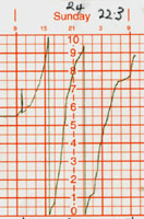
24th: A very misty start to the day with slight rain from 07 GMT. The wind a light E'ly at first became variable and then calm from time to time. The pressure dropped to 978 mb. The slight to moderate rain was continuous for the 24-h period to 09 GMT on the 25th and amounted to 22.3 mm the most in a day this month. Temperature variation was small, from 10.5C at 09 GMT to a minimum of 10.1C before rising again to 11.0 at 09 GMT on the 25th, range 0.9C. Relative humidity was near 100% for the whole period and zero evaporation from the Piche evaporimeter. The little or no wind here was in contrast to the gales (and flooding) in the S along the channel coast from Sussex, where part of the pier at Bognor Regis was swept away, to Kent. There were also strong winds to the N in Scotland.
25th: Pressure was rising and the rain ceased soon after 0900 GMT. In the light NW'ly wind the morning was bright from time to time and there were one or two brief sunny spells in the afternoon. The field and roadside hedges are being trimmed by the local farmers at the moment and, although they look very tidy, the crop of rosehips and other berries have been cut depriving the birds of a useful food supply. In some years flocks of migrating redwings feed in the hedgerows, but this year because of the mild weather they have not yet put in an appearance.
26th: Pressure continues to rise and there were signs of the sky clearing but the morning was slow to brighten. In the afternoon there were cumulus clouds around and a few spots of rain before a clearance gave a sunny end to the day. There was a very spectacular red sky at 1705 GMT as the sun was setting.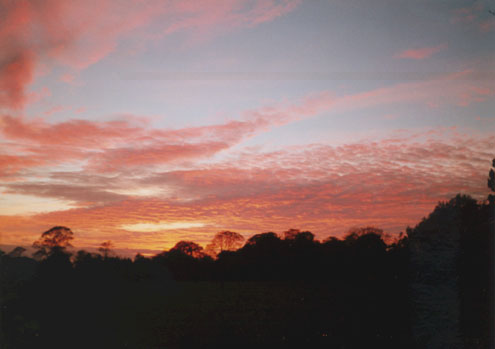
27th: There was low cloud on the mountains and spots of rain on the wind at first before an improvement brought some sunny spells. To the N of here the cloud looked very dark and threatening. The S'ly wind was increasing in strength during the morning and was force 5-6 by noon. The afternoon was dull but was bright and sunny towards Conwy. The wind was force 6-7 gusting 8 at times in the evening and the 2045 pm sailing from Holyhead to Dublin was cancelled due to the bad weather. There was a band of rain from 2100-0100 GMT amounting to 5.6 mm as a warm front moved SE'wards, the wind decreased towards midnight.
28th: After the passage of the front the sky cleared and this led to the formation of low-lying mist on the fields. The mist persisted for some time but had cleared by 0900 GMT. The sky continued to clear through the morning to give a sunny morning with little or no wind. There was a little cloud around noon but this soon dispersed giving a sunny afternoon and evening. The Isle of Man with 8.2 h and places surrounding Liverpool Bay had a very sunny day (Prestatyn 8.1 h, Manchester 7.3 h, Morecambe 7.8 h). The evening and night was clear.
29th: The temperature dropped smoothly through the night (see chart) to a minimum of 4.6C and 0.0C on the grass, the lowest of the month, before the appearance of cloud before dawn prevented a further decline. It was reported that Capel Curig, in Snowdonia, recorded -1C. Bright at first (maximum 14.2C) but cloudier by noon. From Anglesey in the afternoon strong crepuscular rays could be seen over Caernarfon. The wind moved from SW to S and the cloud broke up here to give a sunny end to the day with a maximum of 15.5C. The evening became cloudier and warmer, there was a short heavy shower (1.7 mm) around 1930 GMT. Evaporation from the Piche evaporimeter over 24-hours was 3.1 mls, the greatest of the month.
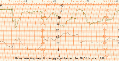 30th: Intense low R (968) to the W of Northern Ireland was moving NE'wards. Overnight a warm S'ly airstream, and a Fohn-like wind from the mountains, resulted in a rise in temperature to a maximum of 18.0C around 04 GMT, the highest maximum this month (see chart). At Aber, Gwynedd, a temperature of 20.5C was recorded. At 09 GMT the temperature was 15.5C in a strong blustery S'ly wind which increased to gale force 8 later. Leaves and twigs were being rapidly stripped from trees and all sailings between Holyhead and Dun Laoghaire were cancelled. At 1220 GMT there was heavy rain (9.4 mm) and the temperature dropped rapidly from 16.8C to 10.2C as a cold front moved E'wards (see chart). The wind decreased for a while but increased again later in the afternoon. The skies cleared in the evening.
31st: It was still very windy but quite sunny. It was very blustery in the SSW'ly wind which again reached gale force 8. The Stena HSS ferry was again cancelled but the Irish Ferries boat of more conventional design was to sail in the afternoon. There were showers, slight rain and drizzle later in the afternoon and a short period of moderate rain about 23 GMT.
Return to top of page
Return to home page
1st: It was still windy after the gales of the last days of October. A SSW'ly force 6 with spots of rain on the wind and rain in sight in poor visibility towards the mountains. Soon turned to slight rain then drizzle in the morning. It looked very black and murky towards Holyhead and there was a short spell of heavy rain early in the afternoon. There was some partial flooding on minor roads and some low-lying fields looked very wet as the soil is now saturated with water. My barometer (997 mb) kicked up about 15 GMT, the wind and rain eased and it was brighter towards the W with a glimpse of the sun through thin cloud at 16 GMT just before sunset. Rainfall here was 6.1 mm but Valley reported 11.5 mm. [Rain 6.1 mm; Max 12.4C; Min 10.4C & Grass 9.5C]
2nd: Much less windy today, WSW'ly force 2 at 09 GMT with slight showers at first. Pressure was rising (1015 mb) as a high near Portugal was moving NE. Sunny spells developed in the morning when the maximum reached 11.5C, although there were cumulus shower clouds the afternoon remained dry. It became cloudier towards sunset and there was a shower of rain about 21 GMT. [Rain 1.3mm; Max 11.5C; Min 6.9C & Grass 3.8C]
3rd: With the high over France and a deepening low over Iceland both moving NE the day here was very dull with a freshening SW'ly wind. The temperature rose to 12.7C in the morning and this turned out to be the highest maximum of the month. This was, remarkably, the coolest highest maximum recorded here in November since records began in 1979. It remained overcast all day, there were showers about but none fell on the station during the day. There were signs of the sky clearing at dusk but this was only temporary. [Rain 0.2 mm; Max 12.7C; Min 7.5C & Grass 6.2C]
4th: Still dull and windy (S'ly force 5) with some spits and spots of rain on the wind. At 1300 the pressure was dropping (1015 mb) and there was slight rain from time to time in the afternoon. Our first winter visitor, a brambling, seen in the garden amongst several chaffinches. It became windier force 6-7 at times and continued near gale force with moderate to heavy rain later in the night. By morning 26.3 mm had accumulated, the most in a day in the month. [Rain 26.3 mm; Max 12.5C; Min 10.1C & Grass 9.3C]
5th: Continuous moderate rain at first but the SW'ly wind had eased to force 2. Pressure (988.7 mb) and still falling. The rain soon eased but continued intermittently moderate. The field opposite our house has standing pools of water for the first time this winter. This is always a good indication that the soil is saturated. Minor roads were also again partially flooded. Brighter with a few sunny spells later in the morning. Pressure fell a little further (985.2 mb), the lowest of the month, before starting to rise soon after 1300 GMT. It became windier and there were heavy showery bursts of rain, which continued into the evening. One particularly heavy burst about 2020 GMT contained small ice pellets. The Britannia bridge was again closed to high-sided vehicles during the day and there was a 30-mph speed limit in force. Ferries from Holyhead were again either cancelled or sailing's doubtful. Capel Curig in Snowdonia reported 62 mm rain in 24 h to 5 pm. [Rain 14.0 mm; Max 10.9; Min 10.1C & Grass 9.8C]
6th: A much brighter day with sunny spells but it felt cold in the NW'ly wind. Passing cumulus clouds looked threatening from time to time but there was no rain fell until a slight shower later in the afternoon. In the hedgerows campion and ragged robin are still in flower. The sky was clearing after dusk and the temperature fell until 21 GMT (4.0C) and to -0.2C on the grass. This was the first ground frost of the winter, the last was on the 19th April. Air temperature remained about 4C until 01 GMT when cloud encroaching from the W led to a rise through till the next morning. [Rain 0.1 mm; Max 11.5C; Min 5.8C & Grass 2.8C]
7th: A cloudy and dull start to the day. Pressure was rising (1025 mb). Visibility was good but the cloud was low obscuring the mountaintops. There was little change during the afternoon but there was a slight shower about 2140 GMT. [Rain 0.2 mm; Max 11.9C; Min 4.0C & Grass -0.2]
8th: An area of high pressure (1032 mb) was building to the west of Britain and slowly drifting E'wards. Cloud level was just below the highest summits on the mainland mountains and there was signs of the cloud breaking up overhead, but before noon it was cloudier again with spits and spots of rain. There was fine drizzle at first in the afternoon, this stopped later but there was a shower at 1730 GMT. Later the sky cleared somewhat. [Rain 0.4 mm; Max 11.7C; Min 9.3C & Grass 6.8C]
9th: High pressure now firmly established (1041 mb). A sunny start to the day with a little patchy cloud and swirls of cirrus. A light NE'ly decreasing throughout the day. A rather mediocre sunset again, we are not getting the spectacular sunsets seen a few years ago. Perhaps there is not so much volcanic dust in the atmosphere at present. [Rain 0.0; Max 11.6C; Min 6.0C & Grass 1.5C]
10th: Some colour in the sky at sunrise leading to another sunny morning. There was a lot of smoke haze in the Menai Strait moderately obscuring the lower slopes of the mountains. The summits above 2500 ft were in the clear. There were some lenticular altocumulus clouds to the S-W. The cloud soon dispersed giving a cloudless sky the rest of the day. Pressure was high (1044 mb). There is a good crop of holly berries this year on a tree near our house. Today, a mistle thrush was eating them and, making churring noises was driving off several blackbirds trying to do the same. It usually happens that the birds eat all the berries before any sprigs of holly can be used decorate the house at Christmas. Visibility became very good in the afternoon with clear views to the Lleyn peninsular. With no clouds at sunset the sky was a beautiful golden colour later turning orange. The new moon low in the sky across slightly misty fields to the SW, at first a silver crescent turned an orange-red colour just before setting just after 1800 GMT. Valley recorded 7.9 h sunshine today. [Rain 0.0; Max 11.3; Min 4.0C & Grass 0.5C]
11th: The night was coolest before midnight when the grass minimum fell to 2.0C. Thereafter it was increasingly cloudy. Cloud was high with patches of blue sky at 09 GMT, but these were short-lived. It was overcast before noon, pressure was falling slowly (1043 mb) and there was slight drizzle from time to time in the afternoon. The day was colder than of late with a maximum of 9.2C in the morning, the coldest day since 15th April. [Rain tr; Max 9.2C; Min 5.7C & Grass 2.0C]
12th: Low cloud with slight drizzle and poor visibility. Periods of heavier drizzle later in the morning but became intermittent in the afternoon. Drizzle later ceased to give a dry but cloudy evening. [Rain 0.2 mm; Max 9.6C; Min 8.0C & Grass 7.3C]
13th: Intermittent drizzle, murky in low cloud but visibility good. There were some breaks in the cloud especially in the mountain passes of Nant Ffrancon and Llanberis where strong crepuscular rays were seen in the morning. The cloud broke up overhead during the afternoon giving some sunny spells when the temperature rose to 11.2C. But it was warmer at Valley (13C), the highest in the UK on the day. There was also a clear patch in the night 0230-0500 GMT when the air temperature fell to 5.2C and on the grass 1.5C before it again became cloudy. The trees are still giving a golden autumnal display. At their best at the moment are the beech, birch and horse chestnut. Some of the sycamore, ash and lime have lost most of their leaves but the Norway maple leaves are still attached and have now turned yellow. The birches planted on cuttings along the A55 expressway to the S of the Britannia Bridge are particularly fine; there were also some yellow brooms in flower on the same banks. Plants still in flower in the garden include Erica daboecia, Welsh poppy, Lithospermum, fuchsia, primroses, rosemary and nasturtium. [Rain tr; Max 11.2C; Min 5.2C & Grass 1.5C]
14th: Pressure slowly declining (1028 mb). Bright at first with signs of the cloud breaking-up but soon turned cloudier again. The was a little rain on a weak frontal system from about 2230 GMT amounting to 0.7 mm. [Rain 0.7 mm; Max 10.9C; Min 5.2 & Grass 1.5C]
15th: Bright at first but mist and fog intermittently, visibility varying between very poor and fog from 0730 GMT. At 0900 GMT moderate fog with sunshine before showers, some prolonged. There was a succession of showers after midnight including ice pellets before the sky cleared to give a second ground frost of the season (-0.8C) before dawn. [Rain 4.8 mm; Max 10.2; Min 7.0 & Grass 4.5C]
16th: Cumulus over the mountains and just to the S of here looking threatening despite the sunny spells. Heavy looking showers with strong crepuscular rays in the Nant Ffrancon pass at 0900 GMT could have been falling as sleet or snow on higher ground. Showers here later in the morning and a reported moderate shower of small hail at Pentraeth. Sunny between the showers in the afternoon, one of which at 1605 GMT included further ice pellets. Snow was seen lying on the mountaintops above 2750 ft in the afternoon. [Rain 5.3; Max 8.5C; Min 2.8C & Grass -0.8C]
17th: Frequent showers including ice pellets in the night. Thin snow on the northern slopes of the mountains visible down to 2000 ft in places on Snowdon and the Carneddau early in the day. A bright and sunny morning, a cold N'ly wind but the temperature rose to 7.0C. It became showery in the afternoon, some moderate to heavy and a few prolonged then persistent rain in the evening until about 05 GMT on the 18th. Rain duration was 14.0 h and this was the greatest number of hours of rain in the month. This ruled out any chance of seeing the Leonid meteorite shower forecast for 02 GMT. [Rain 7.8 mm; Max 7.0C; Min 3.8C & Grass 0.4C]
18th: Cloud base a lot higher this morning so that the mountaintops were visible. A moderate fall of snow in the night with a sharp cut-off at 2500 ft. Another strong display of crepuscular rays in the Nant Ffrancon pass about 0930 GMT. 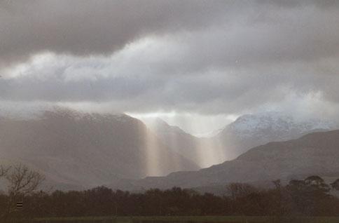 On Anglesey a moderate to fresh N'ly wind made it feel cold although the day had good sunny spells. The Piche evaporimeter recorded in 24 h the most evaporation (2.4 mls) in the month. It turned cloudier towards dusk. [Rain 0.0; Max 5.9; Min 3.7C & Grass 1.7C]
19th: Good sunny spells but again feeling cold in the N-NE force 5 wind. Some spits and spots of rain from time to time under the darker clouds in the afternoon but it did not wet the bottle in the raingauge. First view this winter of a 2-3 redwings in the field adjacent to the weather station. Snow level unchanged on the northern slopes of the mainland mountains. A starry sky with bright moonlight at 2200 GMT. [Rain tr; Max 7.7C; Min 4.1C & Grass 2.5C]
20th: A sunny morning with the wind still in the N. The temperature rose to 9.2C before noon and the relative humidity fell to 64%, the lowest of the month. With only slight dew overnight the grass soon dried and some grass mowing could be done. The grass continues to grow at this time of year and it is always advantageous to give the occasional cut when conditions permit. There is a carpet of rust coloured leaves under some of the trees as there has been little to blow them away, under one particular beech the covering is such that hardly any grass can be seen. Three ravens seen today near the house, they are big birds, larger than crows or rooks and as large as a buzzard. A clear night with the temperature dropping rapidly at dusk. [Rain 0.0; Max 9.2C; Min 3.3 & Grass 0.0]
21st: Everywhere white with frost this morning. The first air frost of the season (-0.4C), the lowest minimum of the month, and the first in November since 1996. There have been 11 Novembers with air frost in the last 20 y, most of them (8) in the decade 1979-88. A pink sky at 0724 GMT but the sun did not get above the mountains until 0822 GMT. The morning was sunny at first, but with pressure dropping (1024 mb) it was cloudier and the wind had become S'ly before 1300 GMT. The afternoon was bright and the visibility good and the snowline today could be seen at about 2800 ft on the mountains. [Rain 0.0; Max 6.1C; Min -0.4C & Grass -3.5C]
22nd: It had been a much warmer night, the low minimum and grass minimum temperatures were recorded near 09 GMT on the 21st and correctly assigned to the 24-h ending 09 GMT today the 22nd. Following early rain the sky was clearing from the W-NW at 0900 GMT and the temperature rose from 5.4C to 9.5C during a sunny morning. The afternoon was at first sunny (maximum 9.9C) before becoming cloudier later. There was lying snow on top of the Carneddau mountains above 3000 ft. Snowdon was obscured by cloud. [Rain 3.8 mm; Max 9.9C; Min 0.3 & Grass -1.8]
23rd: Dull but dry at first turning to slight rain with poor visibility and increasing wind SW force 5-6 later in the morning. The temperature at 09 GMT of 9.9C was the maximum of the previous 24 h. and was to be the minimum for the next 24 h. By the afternoon it was clearing slightly so that by mid-afternoon the mountains could be seen across the Menai Strait. The peaks remained cloud covered but snow patches could be seen above 3000 ft. The view towards Holyhead and Mynydd Bodafon remained murky. On a walk along the lanes in the afternoon I saw 5 redwings feeding in the hedgerows and a kestrel hovering over some rough ground hoping for a catch. Also seen were flocks of 50 or more starlings and rooks feeding on the fields. The fields have been spread with manure some time ago, when the weather was drier, and this attracts the birds to feed. There were also small flocks, 20 or more, of sparrows and chaffinches near a chicken farm. There was still plenty of campions in flower at the base of the now well-trimmed hedges. Great news for local travellers to and fro Bangor and the mainland. The Menai Suspension Bridge reopened at 1900 GMT today, 3 weeks ahead of schedule, after extensive repairs to the deck and road-surface. [Rain 2.2 mm; Max 11.1C; Min 9.9C & Grass 9.1C]
24th: It had been raining slightly since dawn in a S'ly force 7 with slowly dropping pressure (1015 mb) at 09 GMT. Rain continued slight to moderate at first turning heavy, with force 8 squalls around noon, when the wind became more SW'ly as the barometer kicked upwards. The rain continued until 1500 GMT and accumulated 21.5 mm in the 6 h since 09 GMT. Local roads were awash with water and one or two places were partially flooded. The field opposite our house again had extensive pools of water. Further showers in the night brought the total rainfall to 22.8 mm, over only 4.9 h, by morning. The rate of rainfall (4.7 mm h-1) was the highest rate of fall in the month. Capel Curig in Snowdonia recorded 50 mm rainfall up to 1800 GMT. [Rain 22.8 mm; Max 11.4C; Min 9.8C & Grass 9.1C]
25th: Recently clearing sky led to falling temperatures before dawn (Min 6.2C and 3.0C on the grass) and lead to a late deposition of dew. The morning started sunny and smoke haze could be seen in the Menai Strait. Cloud could be seen to the W and this soon encroached giving slight rain before noon. The afternoon became windier (SW'ly force 5-6) and misty with slight rain or drizzle. HSS ferry sailing's from Holyhead were again cancelled in the evening and early tomorrow because of expected adverse weather. Wind strengthened in the evening. [Rain 0.2mm; Max 11.7C; Min 6.2C & Grass 3.0C]
26th: Wind continued to strengthen after 00 GMT and by dawn was a force 7 S'ly. Slight rain at first and with falling pressure (1008 mb) the wind soon reached gale force 8 with very strong gusts. Valley reported a maximum gust of 77 mph. Anything loose was being blown around and some branches were ripped from trees. At Gaerwen it was blowing force 9 for a time and sheets of corrugated iron and other materials were being lifted and blown against a fence at a builder's yard. Irish Sea ferries were badly disrupted and sailings of Stena and Swift boats cancelled. The Britannia Bridge was closed to high-sided vehicles and cars restricted to 20 mph. The Menai Suspension Bridge, only reopened on the 23rd was being used by diverted traffic. At 1215 GMT the barometer kicked up and there was very heavy rain, over 5 mm in under 10 min (and the temperature dropped to 7.1C) as the cold front passed. The wind suddenly dropped away almost to calm and bright sky could be seen in the W. The afternoon passed with a little sunshine later in a light SW wind. [Rain 7.0mm; Max 11.4C; Min 7.8C & Grass 6.6C]
27th: Bright at first, the pressure (1016 mb) was rising but it was cloudier by noon. The day remained dry and some jobs could be done around the garden. The strong winds had blown a lot of the leaves deposited under some of the trees (see diary for 20th) so that most of the grassy areas were clear. In sheltered corners around the house some leaves had piled up and had to be removed to the compost heap. By 1715 GMT it was becoming windy again (S'ly force 6) and there was a shower later. Temperature rose throughout the day from 5.9C at 0900 GMT to 10.5C at 2000 GMT and continued to rise throughout the night reaching 11.6C by morning. Evaporation during the 24 h was 2.3 mls, the second highest reading of the month. Pressure had begun to fall again at 2000 GMT (1009 mb) as a low N to the W of Ireland (992 mb and deepening) was moving E'wards. A rough night ensued. [Rain 0.3mm; Max 12.2C; Min 5.1C & Grass 2.3C]
28th: Very windy, lots of twigs and beechnuts in the air at 0900 GMT in the force 7 S'ly. Pressure was 999 mb and falling as the depression over Valencia (989 mb) was expected to move NE. Gales were being reported at Aberystwyth in the morning and the Met. Office issued an updated gale warning at 0941 GMT of imminent S'ly storm force 10 for the Irish Sea. Later, Valley (Anglesey) and Ronaldsway (Isle of Man) were reporting mean wind speeds of over 42 mph into the afternoon with a maximum gust at Valley of 65 mph. High-sided vehicles were not allowed to cross the Britannia Bridge and speed restrictions were in force for cars. All ferries (high-speed and conventional craft) on the Irish Sea from Fishguard, Holyhead, Liverpool and Stranraer appeared to be cancelled and any sailing's were reported to be doubtful until Monday. The lowest pressure noted here was 997 mb. The wind, roared in the trees most of the day, and together with the very strong gusts brought down many twigs and small branches. Not many leaves are now left on the trees except on Norway maple, a few sycamore, oak, lime, scrub elm and beech hedges. There was rain from about 10 GMT to 17 GMT amounting to 6.9 mm. The strong gusts eased soon after the rain stopped and the temperature fell from 11.5C at 18 GMT to 7.0C by 20 GMT as a cold front passed. The wind at 20 GMT the sky was clearing and the wind SE'ly. The temperature continued to fall throughout the night. [Rain 6.9mm; Max 12.0C; Min 5.9C & Grass 4.2C]
29th: Pressure (1019 mb) was rising slowly and the day was sunny with occasional patches of cloud. Valley had 5.7 h sunshine. The wind was a light W'ly and as the cloud was high with good visibility views of all the mountain summits could be seen (no patches of snow). Lowest temperatures were at 0900 GMT, air temperature 2.5C and -0.4C on the grass showing frozen deposits of dew. The maximum of 10.5C was recorded 24-h later at 0900 GMT on the 30th. A flock of 50, or more, curlews and a few lapwings were spotted during the afternoon on a wet field on the road to Llanbedrgoch. A respite from the gales today as more is forecast for tomorrow. [Rain 0.1mm; Max 10.5C; Min 2.5C & Grass -0.2C]
30th: Pressure was falling very slowly (1020 mb), low cloud with one or two breaks was racing by in a SW'ly force 6-7. The day then remained overcast with occasional spits and spots of rain on the wind until 1610 GMT when, the cloud broke in the west and, there was a dramatic red sky. The temperature at 1600 GMT was 11.4C and rose a little further to 11.7C by about 2045 GMT. Prestatyn, along the North Wales coast, reported 15C in the 24-h to 17 GMT. Soon after 2045 GMT a weak cold front passed by here and there was a sharp shower of rain. Thereafter, the temperature fell slowly until morning. [Rain 0.9mm; Max 11.7C; Min 2.5C & Grass -0.2C]
Return to top of page
Return to home page
1st: There was a clearing but slightly pink sky before sunrise but the morning was mainly cloudy and only bright at times (maximum 8.8C). The afternoon was cloudy with a few spots of rain later. A cowslip was spotted to be in flower in the garden and 100 redwings were seen picking over the field in front of the house. Only 1 came into the defined area in the garden to be counted in our BirdWatch survey! It was a warm night with a minimum of 7.2C, one of the 2 warmest of the month. [Rain tr; Max 8.8C; Min 7.2C & Grass 4.6C]
2nd: Since yesterday morning there has been a steady but small fall in temperature (8.8C to 3.9C). There was cloud on the summits of the Snowdonia mountains above 3000 ft. It remained cloudy and dull with spots of rain at times in the morning turning to heavy showers in the afternoon. There were gale force winds from about 02 GMT and a band of rain from midnight resulted in the accumulation of 15.1 mm by morning. The temperature rose throughout the night to 11.0C by 07 GMT on the 3rd. This was to be the highest maximum temperature of the month. [Rain 15.1 mm; Max 11.0C; Min 3.9C & Grass 0.8C]
3rd: The gale was at its strongest from 0630-0800 GMT, Valley was reporting mean wind speeds of 47 mph and gusts of 60 mph. At the same time Ronaldsway was reporting mean wind speeds of 55 mph and gusts of 71 mph. At Capel Curig a gust of 95 mph was recorded but the highest reported on TV was 100 mph in Humberside. A drilling rig the Maersk Endeavour in the North Sea reported a gust of 114 mph. A tree was blown down, from the W, along the road near our house, but it fell into the field alongside and not on the road. Several other trees in the area suffered a similar fate. The Britannia Bridge was again subject to 20-mph speed restrictions and closed to high-sided vehicles. The HSS ferry was cancelled and the Superferry, on route from Dublin, was reported late. . In the afternoon 100, or more, Lapwings were seen in a wet looking field near Rhoscefnhir on the road to Pentraeth.
With the wind slowly moderating there were some sunny intervals between slight showers, one of which at 1524 GMT was of ice pellets. It was reported to me that there was a snow shower at 1530 GMT on Parys Mountain in NE Anglesey. [Rain tr; Max 7.5C; Min 4.7C & Grass 3.7C]
4th: Cloudy at first with a slight shower of ice pellets at 0845 GMT. The low cloud was breaking up and clearing at 0900 GMT although there were quite active looking cumulus to the SW. There was a fresh cold NW'ly wind but sunny intervals throughout the day. The flock of redwings was again in the field opposite the house in the afternoon. The birds are favouring this field at present because it is relatively sheltered from the NW wind. Although cloud was hugging the summits all day a thin sprinkling of snow was seen on some of the Carneddau mountains at 09 GMT and more about 16 GMT from showers during the day. A further slight shower in the evening. A quiet night, after recent high winds, except for the occasional hoot of a tawny owl. The sky cleared later. [Rain tr; Max 6.0C; Min 3.2C & Grass 0.4C]
5th: There were frozen deposits of dew on the grass first thing and ice on the trays of water put out for birds. The grass minimum thermometer registered -2.1C and it was still reading -0.1C at 0900 GMT. There was cirrostratus overhead, but cumulus could be seen in the distance all around. A light SW'ly at first and becoming cloudier through the morning. The afternoon was dull and there was drizzle then a period of rain from 15 GMT until about 19 GMT amounting to 5.4 mm. By 21 GMT it became windy (SW'ly force 5-6) with pressure falling (1016 mb) at 2200 GMT. The temperature rose throughout the night reaching the 24-h maximum of 10.2C at 0900 GMT on the 6th. [Rain 5.4 mm; Max 10.2C; Min 1.0C & Grass -2.1C]
6th: Dull and slight drizzle and spots of rain on the SW'ly force 5 at 0900 GMT soon turning to rain. A buzzard swooped on our semi-resident male pheasant but got nowhere near him as he noisily took to flight and escaped. Visibility deteriorating from poor to very poor by noon when the temperature was still 10.2C. Misty with further rain in the afternoon but became drier by evening. [Rain 10.8 mm; Max 10.7C; Min 1.4C & Grass -0.1]
7th: There was a long shower of small/moderate sized ice pellets at 0422 GMT. At 0900 GMT there were some thinner patches in the low cloud which was being driven across the sky in a W'ly force 4-5. A light sprinkling of snow could be seen at 2500 ft on the Carneddau mountains. The low cloud prevented a good view of the summits and Snowdon was obscured. It soon brightened up and with the relative humidity at 86% my wife took my advice and hung out the washing. It remained dry with a few sunny intervals until 1220 GMT when there was a shower, so there was a rush to retrieve the almost dry washing before it got wet again. A sparrowhawk was seen hunting for small birds in the garden but was not successful this time. The afternoon was bright and there were good sunny spells at Llanbedrgoch. Here there was a moderate fall of hail (max 7.2-mm diameter) at 1430 GMT, which almost covered the ground and piled up in the valleys on the roof of the house. It was dry and windy at 2200 GMT with the pressure rising slowly (1006 mb), but gales are expected tomorrow. [Rain 9.4 mm; Max 9.0C; Min 6.1C and Grass 4.5C]
8th: Moderate to heavy rain at times from about 08 GMT and with the S-SW'ly wind increasing strong to gale force. Pressure 997 mb. The maximum for the past 24-h was 9.0C at 09 GMT, the temperature having risen throughout the night. With the soil saturated with water it was not long before there were pools of water on the field opposite the house. The roads were awash and, particularly on the way to Beaumaris, there were several inches of water across the road in many places. The rain stopped by about 11 GMT when 14.1 mm had accumulated in less than 4 h. It was less windy in the afternoon, which, for a while, became sunny. By 1630 GMT the SW'ly was picking up again, force 6-7, reaching gale force by 1800 GMT. Pressure 984 mb falling slowly. Valley was reporting mean speeds of 47 mph, gusts of 68 mph an hour later. Ronaldsway (Isle of Man) reported mean speeds of 54 mph (force 10), gusts of 71 mph. Later, at 2050 GMT, Valley also reported mean speeds of 48 mph (just force 10). Ferry services out of Holyhead were disrupted for the night. [Rain 5.2 mm; Max 9.8C; Min 5.0C & Grass 2.4C]
9th: There was a strong SW'ly wind again at dawn, reaching gale force for a while with strong gusts. It was raining slightly at 09 GMT and the morning was blustery with slight rain interspersed with pulses of heavier rain. The fast ferries out of Holyhead were cancelled and the conventional hulled boat from Ireland was reported to be running 9 h late. The afternoon continued with blustery showers but brightened later with even a sunny interval. By 2200 GMT the pressure had risen to 991 mb, the wind had eased, and it was a quiet night. [Rain 5.9 mm; Max 7.4C; Min 5.7 & Grass 4.2C]
10th: The temperature overnight fell to 3.6C and 0.2C on the grass. There was some ice pellets mixed in a shower of rain between 04-0645 GMT. Pressure was steady at 999 mb, cloud and mist was clearing away, at 09 GMT, except over the mountains where the cloud base was at about 2000 ft. Some cumulus clouds were hanging over central Snowdonia. A sprinkling of snow could be seen at 2000 ft and later viewing indicated snow lying above 2800 ft. It was bright at times in the morning but there were showers of ice pellets at 1110 and 1155 GMT. The day maximum was 5.7C near 1300 GMT. The afternoon was dry and bright at first, but thicker cloud from the W brought intermittent rain from 1530 GMT and persistent rain in the evening until 23 GMT.  The temperature rose 5.5C from 20-23 GMT as a warm front passed through. Pressure was falling (987 mb) at 2200 GMT. [Rain 8.5 mm; Max 9.8C; Min 3.6C & Grass 0.2C]
11th: It was warmest from after midnight with a maximum of 9.8C about 04 GMT. There was another period of rain amounting to 4.5 mm from 07 GMT to 11 GMT after this rain was intermittent and generally slight. Pressure was 980 mb at 1300 GMT and was towards the centre of a low-pressure area to the N of here. Winds were consequently light. There were gale warnings, for adjacent sea areas, but not for the Irish Sea. There was intermittent slight or moderate rain in the afternoon, even a short bright spell, and a dry spell and a clearer sky in the evening. More serious rain began about 03 GMT. Capel Curig reported 52 mm of rain in the 24-h to 5 pm. Rainfall for the 24-h period was 26.5 mm, the greatest fall in the month. [Rain 26.5 mm; Max 9.7C; Min 3.5C & Grass 1.2C]
12th: At dawn there was continuous moderate rain which continued until 1130 GMT. During this period 26.7 mm fell at an average rate of 3.1 mm per h. Thereafter the rain was more intermittent and slight. At 09 GMT the ground was very wet with extensive pools of water standing on the fields surrounding the house and weather station. During the morning a small stream of water was flowing across the garden, from higher ground in a field to the NE, and out on to the road past the house. I have only seen this happen once before during following heavy rain when the ground was saturated with water. Needless to say the roads in the area were awash from similar runoff waters. Capel Curig reported a high rainfall total for the second day running, 48 mm in the 24-h to 5 pm. There was just a flash of red sky in the W at 1600GMT and some mist across the fields, which soon cleared. The sky had cleared by 20 GMT and there was a drying wind. [Rain10.3 mm; Max 5.7C; Min 5.0C & Grass 4.6C]
13th: The temperature had fallen to 2.7C and there was a slight frost on the grass (-0.4C). At 0900 GMT, along with frozen water droplets, there were signs of ice pellets which had not melted since they fell at 0520 GMT. Although there were signs of the sky clearing this was delayed. There were spots of rain and then a moderate shower before noon. The temperature was only 4C and the rain looked almost sleety, it was seen subsequently that snow had fallen on the mountains down to 1000 ft in places. The afternoon was bright and sunny, there were some quite active looking cumulus clouds around and a shower of ice pellets fell in Llanbedrgoch but not here. Later, at 2135, there was a moderate fall of ice pellets that almost covered the ground. [Rain 8.7 mm; Max 4.7C; Min 2.7C & Grass -0.4C]
14th: There had been further falls of ice pellets after midnight and some was still lying at first light on the ground and in the valleys of the roof of the house. The first view of the mountains revealed that there had been further snowfall. One mountain, Moel Eilio (2382 ft) near and SW of Llanberis, when covered with snow looks like Mt Fuji, but of course it is too near and too low, but quite impressive nevertheless. At 0820 and 0830 GMT there were showers of snow pellets which completely covered the ground and thunder was heard at 0838 GMT. Just before 0900 GMT there were more snow pellets followed by oval shaped hail measuring up to 9 mm diameter. Soon after it began to snow, and together with the initial falls of hail gave a ground covering of at least 65%. The temperature at 0900 GMT was 0.5C but it had recently been as low as -0.2C for 2 h and -3.0C on the grass. After the showers had cleared the morning was bright and at times sunny but the temperature had only risen to 2.7C by 1300 GMT. The afternoon had sunny spells but showers clouds threatened and some delivered mixtures of hail and sleet or snow across Anglesey and the mainland mountains. On the approach to Pentraeth from the S on the A5025 about 1320 GMT a spectacular complete primary rainbow could be seen in a shower. Another shower of ice pellets fell at Llanbedrgoch at 1415 GMT. During the afternoon in Llansadwrn there was a moderate shower of sleet around 15 GMT and another shower of hail measuring up to 9.7 mm diameter fell at 1730 GMT. [Rain 1.3 mm; Max 4.0C; Min -0.2C & Grass -3.0C]
15th: The day dawned fairly clear and dry. Temperature at 09 GMT was 3.7C and having recently been 4.0C, the maximum credited to the 14th. The minimums were those recorded at 09 GMT on the 14th. Relative had been lowish in the night, maximum 81%, and was currently 71%. Concrete and grass were dry! The wind was cold and from the NE but it was bright and sunny at times. There were superb views of the Snowdonia mountain range where snow could be seen lying as low as 750 ft below Ysgolion Duon and the Nant Ffrancon and Llanberis passes. The day remained dry although a snow shower could be seen in the afternoon passing the NW corner of the island. The daytime maximum was 5.5C and the relative humidity had been as low as 62%. The Menai Suspension Bridge was closed again today for 5 h to allow engineers to inspect small cracks, which had appeared in the new road-surface. [Rain 0.2 mm; Max 5.5C; Min 0.5C & Grass 0.1C]
16th: At daybreak cloud was hanging low over the mountains and was slow to lift. The wind was very light N'ly at 0900 GMT. The temperature was 4.1C; this was to be the lowest of the 24-h period. As the wind backed slowly to the NW-W it became brighter the temperature reaching 7.3C, but the maximum of 10.2C was not to occur until 0800 GMT the next day. Later in the afternoon it became cloudier again and the wind became a SW'ly force 5-6 by 1800 GMT when the pressure was 1021 mb. The evening was increasingly windy, touching gale force for a while, with some moderate gusts before decreasing around midnight. There was a band of moderate to heavy rain from 22-03 GMT followed by showers. In all 15.6 mm of rain accumulated by morning over 7.0-h duration. [Rain 15.6 mm; Max 10.2C; Min 3.1C & Grass -1.0C]
17th: A dull and dark start to the day although a very narrow band of clear sky could be seen to the NE. Pressure was just starting to rise (1000 mb) but the clear sky took until 1300 GMT to reach here. It took the rest of the afternoon to move further W when at 1630 GMT under clear sky it began to freeze on the grass (-1.0C). Satellite pictures in infrared showed a narrow band of cloud stretching across Anglesey. Much of the snow on the mountains even to the summits has melted leaving only patches on the north facing slopes. [Rain tr; Max 9.0C; Min 4.1C & Grass 1.1C]
18th: It had been a cold night with an air frost (-0.6C), there was hoarfrost and on the grass the temperature fell to -5.3C. The sun was just rising above the mountains at 09 GMT, there was patchy altocumulus clouds moving E with stratus on all horizons. It was calm and there was smoke hanging in the Menai Strait but the view of the summits was very good. It became cloudier during the morning and at 1300 GMT with a light NE'ly a lot of smoke could be seen drifting W in the Menai Strait to a height of 2000 ft. The source of this smoke was a large fire near Bangor. The day's maximum was only 2.7C, the lowest of the month. Later the sky cleared. Heavy snowfall occurred over southern England and South Wales. [Rain 0.0 mm; Max 2.7C; Min -0.6C & Grass -5.3C]
19th: Early patchy cloud was clearing and there was a cold N'ly wind (force 4). Although there was a little patchy cloud from time to time the day was largely sunny with the maximum rising to 3.8C in the morning. The day remained dry. There was clear sky in the evening and there was bright moonlight from the nearly full moon. The brightness of the moon does vary and currently it is the brightest it has been for some years. One report said 130 years and another since 1930! The reason given was that the moon's orbit is at present nearest to the earth. The brightness varies by some 14%. [Rain 0.0 mm; Max 3.8C; Min -0.1C and Grass -3.5C.]
20th: It had been the coldest night of the month and of the year with the air temperature falling to -2.2 C and -5.5C on the grass. At Sennybridge in Powys the temperature dropped to -14C, the lowest reported in the UK. There was red sky over the mountains at 0735 GMT, which became more widespread but diluted in colour by 0825 GMT. The old saying 'red sky in the morning a sailors warning' was to be proved correct on this occasion. It became cloudier by 09 GMT, it was calm and the temperature rose only slowly from 0.0C to 1.5C by 1300 GMT. The morning was dull but by 1300 GMT there was a force 2 S'ly that backed to SE during the afternoon. Between 1200 GMT and 1500 GMT (with slowly rising temperature) the relative humidity dipped sharply to a minimum of 53% at 1300 GMT, the lowest of the month. It became increasingly windy and by 2100 GMT it was blowing force 5-6. After midnight the wind veered S'ly and reached gale force for about 2 h and some very strong gusts buffeted the house. From 0250 GMT Valley reported a mean wind speed of 46 mph (force 9) with gusts of 59 mph. There was a little rain in the night (0.9 mm) and the temperature rose to a maximum of 7.2C just before 09 GMT on the 21st. [Rain 0.9mm; Max 7.2C; Min -2.2C and Grass -5.5C]
21st: A clearing sky but cloud was low over the mountains and to the SW and NE. Although visibility was only moderate a glimpse of the summits of the Carneddau showed that there had been only a sprinkling of snow. Heavy rain or snow had been forecast. Cirrus together with some cumulus clouds to the W and over the mountains to the S did not prevent it being a largely sunny day. The maximum rose to 9.5C around noon. A burst water main at Pentraeth about 06 GMT had washed a lot of gravel out on to the road and was being repaired during the day. The lighter wind and a dry and sunny afternoon enabled some jobs to be done in the garden. [Rain 0.0 mm; Max 10.0C; Min 0.0C & Grass -0.7C]
22nd: It was overcast and dull at daybreak with a temperature of 10.0C at 0900 GMT, the maximum for the past 24-h. Soon after there was slight rain and the morning was blustery in the force 7 S'ly wind. Speed restrictions and closure to high vehicles occurred on the Britannia Bridge but the wind may have only touched gale force. Ferries out of Holyhead were delayed or cancelled. There was further slight to moderate rain in the afternoon and an unexplained rumble at 1610 GMT, there were no spherics in the area. Later the cloud thinned and became broken. The full moon (at its brightest- see 19th) was seen through thin and broken cloud to the SE at 2030 GMT and again to the NW at 0730 GMT on the 23rd just before setting. [Rain 5.7 mm; Max 10.2C; Min 7.0C & Grass 4.4C]
23rd: Slightly broken largely cumulus clouds around with blustery showers during the morning becoming overcast and windier by 1300 GMT. Further blustery showers in the afternoon heralded S'ly gale force winds from about 1600 GMT. The wind increased to force 9 at dusk and into the evening. Mean wind speeds at Valley were exceeding 52 mph. A branch of a Scots pine tree was broken off and blown on to the road and a large beech tree at the entrance to Treffos blown down. There was much tree debris in the air, small twigs and a few beechnuts, and being blown with force on to our roof and against windows. There was a band of moderate rain from 1830 GMT ending with the wind easing around 2100 GMT. There were reports of force 10 in the Irish Sea causing ferries, busy for Christmas, to be severely delayed or cancelled. [Rain 11.7 mm; Max 9.5C; Min 5.1C & Grass 2.3C]
24th: There was a shower of hail (>5mm) at 0438 GMT, spherics were recorded in the area between 05-06 GMT but no thunder was heard. Pressure was 991 mb and skies were clearing at 0900 GMT. There were cumulus clouds around and particularly over the Snowdonia mountains. The morning was bright with some sunny spells for a while but was cloudy again by noon. With a deepening complex low (955 mb) to the N of Scotland the afternoon became wet and windy with the barometer readings dropping quickly, 972 mb at 1600 GMT and 965 mb at 1800 GMT.  The S'ly wind backing SW-WSW'ly was at gale force 8 touching force 9 for a while. A severe weather warning was issued for the Irish Sea. The minimum temperature was 7.2C, one of the 2 warmest of the month. Many Welsh rivers were on amber or red flood alert. On the S coast of England and especially Pevensey, in E Sussex, people were evacuated from their homes as an exceptional high tide and tidal surge was forecast. [Rain 5.6 mm; Max 10.8C; Min 7.2C & Grass 4.9C]
25th: Christmas Day. During the night there were showers of snow pellets and ice pellets (0220 GMT) and hail (0332 and 0808 GMT). At 0816 GMT during a particularly squally shower there were several cracks of thunder, and lightning strikes to ground to the SE of here near Llandegfan. Some 2000 homes in Bangor (Gwynedd) and parts of Anglesey were without electricity for a while but were reconnected by noon. With the low now to the NE of Scotland (940 mb), at 0900 GMT the pressure was rising (979.5 mb), the sky was clearing, and the temperature was 2.7C. The morning was bright but active looking cumulus clouds were in the vicinity and resulted in another squally shower at 1144 GMT with ice pellets and some large hail. From noon there were sunny spells with the maximum reaching 5.7C, but the blustery SW'ly wind (force 5) continued. The evening had broken thin cloud through which the now waning moon was visible. [Rain 8.5 mm; Max 5.7C; Min 2.7C & Grass 1.2C]
26th: Boxing Day. There was a cluster of hail showers at 0630, 0704, 0722 and 0728 GMT. The shower at 0728 GMT lasted for about 5 mins and contained hail more than 8 mm diameter covering the ground up to 2 cm deep. Some stones, estimated to be about 360 per m², were more than 10 mm diameter. This fall, when melted, was 6.5 mm and equivalent to 78 mm per h. Though melting, the hail persisted on the ground until 0900 GMT giving a sufficient cover (>50%) on concrete and grass to be recorded as ice lying (1 cm). The morning was bright but there were showers of sleet, at 1410 GMT, and rain during the afternoon before becoming dry in the evening. [Rain 2.0mm; Max 5.1C; Min 2.7C & Grass 0.2C]
27th: There was a fall of hail at 0250 GMT, which was still visible on the grass and in the gutters of the house by morning. Just before 0900 GMT there was some ice pellets mixed in rain but the sky was clearing and the morning became bright. A Greater Spotted Woodpecker was heard drumming on a tree across the fields. The maximum for the day was 4.5C around 1300 GMT. The afternoon was cloudier, at first thin through which the sun could be seen, then thicker with a shower of rain around 1430 GMT. There was a further shower of ice pellets with rain at 2200 GMT. Seen in flower in the garden this week were primroses, rosemary, Erica var. Winter Beauty, and in pots against the house a zonal Pelargonium is a mass of flowers. Catkins have been seen this month on hazel in the garden and alder. There are still a few flowers of campion on plants along the hedgerows with the yellow flowers of gorse in abundance. [Rain 3.1 mm; Max 4.5C; Min 2.8C & Grass -0.5C]
28th: There were more showers of ice pellets from 01 GMT onwards and more at 0900 GMT. The day continued to have a showery look with numerous cumulus clouds in the vicinity and over the mountains. The morning and afternoon was bright with a few sunny spells with the maximum reaching 4.3C. In places in the garden where the sun did not reach ice pellets remained on the grass all day. Towards sunset, with backlit cumulus clouds in the SW-W in late stages of development, there was a spectacular display of crepuscular rays. At 2200 GMT the barometer was rising (1009 mb) and there was a clear sky with bright stars. [Rain 1.0mm; Max 5.2C; Min 0.3C & Grass -2.7C]
29th: A calm morning, there had been a moderate ground frost (-3.2C) with deposition of ice crystals (hoarfrost). Ice pellets from yesterday morning were still on the grass together with refrozen water and freshly deposited ice crystals. The sky had 4 oktas cloud cover; cumulus clouds were all around with some altocumulus and cirrostratus. Pressure was rising (1015 mb) as a ridge of high pressure was moving in from the W. The day was bright with good sunny spells with a maximum of 6.0C. There was a further display of colourful crepuscular rays between 1555-1605 GMT. There were all shades of gold and purple in the sky above the dark backlit cumulus. After sunset higher clouds were coloured pink. The barometer was still rising (1021 mb) at 2200 GMT and the sky cleared sufficiently to give a ground frost (-2.1C), but by 03 GMT it had clouded over and was raining moderately as warm fronts moved in from the Atlantic. [Rain 12.8 mm; Max 7.0C; Min 0.5C & Grass -3.2C]
30th: There was continuous moderate rain at 0900 GMT and 12.8 mm had accumulated since 03 GMT. It continued raining until 15 GMT when another 13.2 mm had accumulated. In the 12-h of rain 26.0 mm had accumulated, an average fall of 2.2 mm per h. The highest rainfall reported in the UK for the 24-h to 18 GMT was 21 mm at Aberdaron in Gwynedd. The ground was waterlogged and there was standing water on several surrounding fields. Runoff caused extensive flooding of minor roads. The roads to Llanbedrgoch and Beaumaris were particularly badly affected. [Rain 13.2 mm; Max 8.0C; Min 1.0C & Grass -2.1C]
31st: It had been a warm night with the temperature not falling below 6.0C. There was a pink sky before the first rays of the sun appeared over the top of the Snowdonia mountains at 0903 GMT. There were signs of the cloud lifting and the sky clearing but a band of clouds could be seen to the west. It was not long before this cloud had encroached to give a little drizzle by mid-morning. The temperature at 1300 GMT was 9.4C, the day's maximum. Snow showers were seen over the Carneddau mountains early in the afternoon giving a fresh light covering in places. There was more drizzle and light rain later in the afternoon and visibility had become very poor. The SW'ly wind had increased to force 4-5 by dusk but soon decreased as the sky cleared. The beginning of the millennium year 2000 was celebrated by people in the area with the lighting of beacons and fireworks. [Rain 6.4 mm; Max 9.4C; Min 5.8C & Grass 4.2C]
Return to top of page
Return to home page
Another wet year and with 1286 mm it was the wettest since 1967 (1378 mm). There have only been 4 wetter years in the records since 1928. The wettest was 1957 (1410 mm). The number of rain days (0.2 mm or more) was 226, wet days (1.0 mm or more) 178 and days of 5 mm or more totalled 95, all were most in records here since 1979. The wettest months were January with 193.4 mm and December just the wetter with 193.8 mm. The driest month was July with 26.1 mm. July also had the highest temperatures with a mean maximum of 20.7C (+0.8) and the highest maximum of the year of 27.5C on the 31st. Other summer months were very disappointing. The mean maximum for the year was 13.6C (+0.1). Minimum temperatures were greater than average during the year with the annual mean on 7.4C (+0.6). The mean worked out at 10.5C (+0.4) but until the beginning of December was running at 11.2C which, had December not been the coldest month of the year, it would have been the warmest year on record. December's mean was 5.3C (+0.1) but had only 4 air frosts but 13 ground frosts. The lowest air temperature of the year was -2.2C on December 20th, which also had the lowest grass minimum of -5.5C. The number of air frosts in the year were 13, more than the 9 in 1998 but third lowest since records began in 1979. This number was well below the COL average of 22 and the LTA of 31. The year was air frost-free from 17 April to 20 November. The number of ground frosts was 51, the lowest since the 47 recorded in 1990. The year was free of ground frosts between 20 April and 6 November. The number of days with sleet or snow totalled 10; this was only slightly below the average of 12. The number of days with snow lying was only 2, just below the average of 3. The number of days with thunder was 11; this was above the COL average of 7.1 and the LTA of 6, continuing the trend of more thunder events in recent years. This also applies to the number of days with hail (of all types) there being 37. This was 1 more than the previous record of 36 days set last year (1998).
Return to top of page
Return to home page
Document dated: 31 December 1999. This page is maintained at http://www.llansadwrn-wx.co.uk
© 1999 Donald Perkins. All Right Reserved.