Llansadwrn (Ynys Môn) Weather Station
Climate Prediction Model Experiment
The observer's Wx-model


|
Llansadwrn (Ynys Môn) Weather Station
|

|
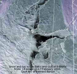
The NOAA 18 satellite image of the region around the Baltic and Gulf Of Bothnia was captured at 1222 GMT on 17 February 2006 (Image courtesy of NOAA and made available by Bernard Burton). The distribution and amount of 'permanent' ice around the poles, Greenland, mountain glaciers and elsewhere is fundamentally important to the climate of Planet Earth and it's weather systems, terrestrial and ocean ecosystems. The Hadley Centre for Climate Prediction and Research 1 has indicated that by 2050 there could be 60% less snow in the Scottish Highlands. The frequency and amount of snow on the Snowdonia Mountains has been decreasing. Will there be any snow in on the mountains in 2080? In recent years the amount of ice at the north and south poles has been diminishing and sea levels rising; recent studies indicate that the speed of disappearance is increasing. The Baltic and Gulf of Bothnia usually ices over in the winter, in recent years the process has been slower and this year is not yet complete. Will it ice over in 2007? Will there be any ice there in 2080?
BBC Four, in conjunction with the UK Met Office and Oxford University, organised the world's largest ever climate experiment 2.
Trying to predict climate change is difficult and needs massive computer power. There are many factors involved air temperature, sea temperature, cloud cover, carbon dioxide and sulphate levels in the atmosphere all play a part there are many other variables. Therefore, a large number of calculations need to be done.
These days your home PC has huge power and most users use little of this power. Usually there is plenty left even when working with the odd spreadsheet or two and a wordprocessor. There are times when the computer is idle and resources are just not being used at all. Using a technique known as distributed computing it is possible to utilise the power of thousands of PCs around the world to do a number crunching job that even the largest supercomputer could not handle. This is possible through the use of special software that runs in the background on your machine when it is switched on. The computer's resources are allocated such that when you are working little or no resources are used. When idle the software can use most if not all the resources available. I have been using the software (courtesy of the BOINC Project 3
University of California at Berkeley) and started running a model on 15 February at 2238 GMT. The model started in 1920 and, if it predicts conditions within certain parameters in about 2000, ran on to 2080. There is graphical output to look at, an optional real-time screensaver (but this does slow down the computations if left on for long time) and you can compare your results with other models. Data are sent back ('trickled') to base automatically when connected to the Internet. My first model was completed by May 2006 and a second started and is 40% completed and sent data back ('trickled') to base.
 The program stores data on disk every 6 days; if you want to switch off your computer do it at the beginning of the next cycle to minimise data loss. I have noticed little or no effect when working with my computer, but you do need a fairly up to date machine (running Windows Vista, XP or 2000, have plenty of disk space and memory available and have a broadband connection).
Many thousands all over the world signed up, many joining teams. If you feel you can commit the resources of your computer to this project, and satisfy yourself that it is for you, then why not join the dedicated band of number-crunchers. It may help in predicting and understanding whether or not there will be ice on the Baltic and Gulf of Bothnia and snow on Snowdon in years to come.
The BBC are no longer accepting new entrants, but you can join in by going directly to ClimatePrediction.net 4 here
What happens after you install the software
Climate change in Llansadwrn, Anglesey?
My weather station has been in operation for 28 years. The record is just long enough to begin to see some trends in the observations.
 I have looked at the winter mean temperatures and the graphic shows the result. The linear regression indicates a significant (P= <0.01) temperature rise of about 1C since 1979.
The annual mean temperature in 2006 was 10.8C and was (+0.5) and [+0.95] of the decadal and 30-y station averages. It was the highest recorded since records began in 1979.
![]()
![]() The graph shows the mean plotted over the 28-years of station records together with a smoothed graph. Fitted to a linear regression the temperature increases over the period by over 1C, an indication the warming trend that has taken place in recent years. The histogram shows the mean anomaly over the same period (differences from the 1971 -2000 climatological mean). Since 1979 there have been 11 years with an anomaly of +0.5C, or more.
The graph shows the mean plotted over the 28-years of station records together with a smoothed graph. Fitted to a linear regression the temperature increases over the period by over 1C, an indication the warming trend that has taken place in recent years. The histogram shows the mean anomaly over the same period (differences from the 1971 -2000 climatological mean). Since 1979 there have been 11 years with an anomaly of +0.5C, or more.
While the records are just from one station it is interesting that a temperature rise can be seen in these data. There are other examples, in the monthly reports on the website, that I will gather together on a page when I have time.
REFERENCE
These pages are designed and written by Donald Perkins. Copyright © 1998 - 2007Document dated 18 February 2006http://www.llansadwrn-wx.co.uk |