
Llansadwrn (Anglesey) Weather
Observations from the observer's spreadsheet
SEPTEMBER 2014
|
Llansadwrn (Anglesey) Weather
|
|
|
|
CLIMATOLOGICAL OBSERVATIONS AT LLANSADWRN, ANGLESEY, FOR SEPTEMBER 2014
|
|||||||||||||||||||||||||||||||||||
| ------09 GMT---> | <-------Air temperature--------> | <---Soil temp---> | <---Earth temp---> | <--State Grd.--> | Rain | Sol | <-------Weather-------> | Press | Pptn | Fr. | Pch | ||||||||||||||||||||||||
| DD | N | dd | ff | V | ww | Temp | Dpt | RH | Max | Min | Mean | Gmin | 5cm | 10cm | 20cm | 30cm | 50cm | 100cm | E | C | Gr | SS | mm | MJ/m2 | S | L | H | T | G | F | mb | W hrs | hrs | evap | |
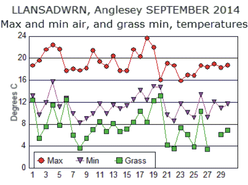
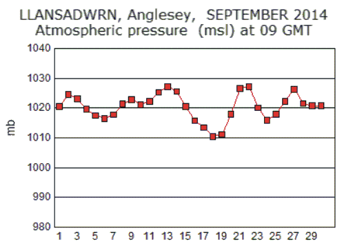
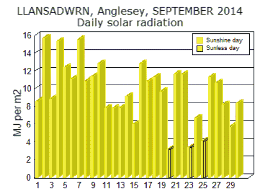
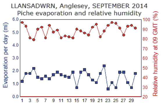
| 1 | 7 | N | 2 | 7 | 02 | 13.9 | 13.4 | 97 | 18.7 | 13.2 | 16.0 | 12.4 | 17.0 | 16.5 | 16.4 | 16.7 | 16.3 | 15.8 | 1 | 2 | 3 | 0 | 0.0 | 8.64 | 1021 | 0 | 0.0 | 1.2 | |||||||
| 2 | 8 | 00 | 0 | 7 | 02 | 14.1 | 12.9 | 93 | 19.6 | 9.7 | 14.7 | 5.5 | 15.1 | 15.0 | 15.8 | 16.2 | 16.2 | 15.8 | 1 | 0 | 1 | 0 | 0.0 | 15.72 | 1025 | 0 | 0.0 | 1.8 | |||||||
| 3 | 7 | NE | 1 | 7 | 02 | 16.9 | 13.7 | 81 | 21.6 | 11.9 | 16.8 | 7.6 | 16.2 | 15.6 | 16.0 | 16.3 | 16.4 | 15.7 | 1 | 0 | 1 | 0 | 0.0 | 8.90 | 1023 | 0 | 0.0 | 1.8 | |||||||
| 4 | 6 | SE | 1 | 7 | 04 | 18.9 | 15.2 | 79 | 22.4 | 15.7 | 19.1 | 11.5 | 17.5 | 16.8 | 16.6 | 16.8 | 16.6 | 15.8 | 0 | 0 | 1 | 0 | 0.0 | 15.37 | 1020 | 0 | 0.0 | 2.2 | |||||||
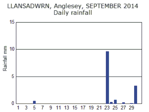
| 5 | 6 | NE | 1 | 5 | 06 | 16.4 | 14.7 | 90 | 21.7 | 11.2 | 16.5 | 7.8 | 16.6 | 15.5 | 16.5 | 16.9 | 16.7 | 15.8 | 0 | 0 | 1 | 0 | 0.5 | 12.44 | 1018 | 2 | 0.0 | 1.5 | |||||||
| 6 | 7 | NE | 2 | 7 | 01 | 13.0 | 11.7 | 92 | 17.7 | 12.7 | 15.2 | 12.5 | 15.9 | 16.2 | 16.8 | 17.0 | 16.8 | 15.9 | 1 | 2 | 3 | 0 | 0.0 | 11.10 | 1017 | 0 | 0.0 | 1.4 | |||||||
| 7 | 5 | N | 3 | 7 | 02 | 13.8 | 10.6 | 81 | 18.1 | 9.9 | 14.0 | 6.0 | 15.0 | 14.6 | 16.1 | 16.6 | 16.6 | 16.0 | 0 | 0 | 1 | 0 | tr | 15.56 | 1018 | 0 | 0.0 | 1.6 | |||||||
| 8 | 7 | NE | 1 | 6 | 04 | 11.7 | 10.8 | 94 | 17.8 | 8.2 | 13.0 | 3.7 | 14.8 | 14.0 | 15.3 | 16.0 | 16.4 | 16.0 | 0 | 0 | 1 | 0 | 0.0 | 10.87 | 1021 | 0 | 0.0 | 1.4 | |||||||
| 9 | 5 | S | 1 | 7 | 01 | 12.8 | 10.7 | 87 | 18.2 | 9.0 | 13.6 | 5.5 | 14.2 | 13.7 | 15.0 | 15.7 | 16.2 | 15.8 | 0 | 0 | 1 | 0 | 0.0 | 11.40 | 1023 | 0 | 0.0 | 1.7 | |||||||
| 10 | 4 | N | 1 | 6 | 04 | 14.5 | 12.7 | 89 | 21.4 | 9.9 | 15.7 | 7.0 | 14.7 | 13.7 | 15.0 | 15.3 | 16.0 | 15.8 | 0 | 0 | 1 | 0 | 0.0 | 12.84 | 1021 | 0 | 0.0 | 1.9 | |||||||
| 11 | 4 | E | 1 | 6 | 04 | 16.5 | 13.2 | 81 | 19.4 | 11.7 | 15.6 | 8.5 | 14.2 | 14.5 | 15.2 | 15.8 | 16.1 | 15.8 | 0 | 0 | 1 | 0 | 0.0 | 7.91 | 1022 | 0 | 0.0 | 1.7 | |||||||
| 12 | 4 | SW | 2 | 5 | 04 | 14.8 | 12.0 | 83 | 18.5 | 9.9 | 14.2 | 6.7 | 12.7 | 13.4 | 15.2 | 15.7 | 16.1 | 15.8 | 0 | 1 | 1 | 0 | 0.0 | 7.83 | 1025 | 0 | 0.0 | 1.6 | |||||||
| 13 | 6 | N | 2 | 7 | 04 | 17.3 | 14.2 | 82 | 20.4 | 11.5 | 16.0 | 8.1 | 16.6 | 15.7 | 15.8 | 16.0 | 16.2 | 15.8 | 0 | 0 | 1 | 0 | 0.0 | 7.88 | 1027 | 0 | 0.0 | 1.5 | |||||||
| 14 | 6 | NE | 3 | 7 | 04 | 14.8 | 11.5 | 81 | 17.7 | 10.8 | 14.3 | 6.7 | 14.6 | 14.2 | 15.5 | 15.8 | 16.0 | 15.7 | 0 | 0 | 1 | 0 | 0.0 | 9.20 | 1026 | 0 | 0.0 | 1.9 | |||||||
| 15 | 8 | N | 2 | 6 | 03 | 14.2 | 12.6 | 90 | 17.7 | 11.4 | 14.6 | 7.1 | 14.4 | 14.1 | 15.3 | 15.7 | 15.9 | 15.7 | 0 | 0 | 1 | 0 | tr | 6.03 | 1021 | 1 | 0.0 | 0.7 | |||||||
| 16 | 4 | 00 | 0 | 6 | 04 | 16.7 | 14.7 | 88 | 21.6 | 12.5 | 17.1 | 8.4 | 16.3 | 15.4 | 15.4 | 15.7 | 15.9 | 15.8 | 0 | 0 | 1 | 0 | 0.0 | 12.85 | 1016 | 0 | 0.0 | 1.9 | |||||||
| 17 | 5 | NE | 3 | 6 | 04 | 16.6 | 14.3 | 86 | 20.3 | 14.2 | 17.3 | 10.4 | 14.9 | 15.2 | 15.8 | 16.2 | 16.3 | 15.6 | 0 | 0 | 1 | 0 | 0.0 | 10.85 | 1014 | 0 | 0.0 | 2.1 | |||||||
| 18 | 6 | N | 3 | 6 | 02 | 17.1 | 14.4 | 84 | 23.7 | 12.4 | 18.1 | 8.4 | 16.4 | 15.6 | 16.1 | 16.2 | 16.5 | 15.8 | 0 | 0 | 1 | 0 | 0.0 | 11.34 | 1011 | 0 | 0.0 | 1.7 | |||||||
| 19 | 4 | S | 2 | 5 | 05 | 17.9 | 16.6 | 92 | 22.0 | 14.9 | 18.5 | 12.3 | 17.8 | 17.1 | 16.8 | 16.8 | 16.5 | 15.7 | 0 | 0 | 1 | 0 | 0.0 | 9.72 | 1011 | 0 | 0.0 | 1.3 | |||||||
| 20 | 8 | NE | 4 | 6 | 02 | 14.9 | 14.2 | 95 | 16.1 | 14.7 | 15.4 | 13.2 | 16.8 | 16.8 | 16.8 | 17.0 | 16.7 | 15.8 | 0 | 0 | 1 | 0 | tr | 3.18 | 1018 | 1 | 0.0 | 1.1 | |||||||
| 21 | 2 | N | 2 | 7 | 02 | 14.1 | 11.1 | 82 | 19.1 | 9.7 | 14.4 | 4.2 | 13.5 | 13.6 | 15.4 | 16.0 | 16.4 | 15.9 | 0 | 0 | 1 | 0 | 0.0 | 11.68 | 1027 | 0 | 0.0 | 1.8 | |||||||
| 22 | 2 | S | 3 | 7 | 04 | 13.6 | 11.6 | 88 | 18.7 | 8.6 | 13.7 | 3.6 | 13.1 | 13.3 | 14.9 | 15.5 | 16.2 | 15.7 | 0 | 0 | 1 | 0 | 0.0 | 11.60 | 1027 | 0 | 0.0 | 2.4 | |||||||
| 23 | 7 | SW | 3 | 6 | 02 | 14.7 | 13.8 | 94 | 15.9 | 11.7 | 13.8 | 7.4 | 15.3 | 15.1 | 15.4 | 15.8 | 15.9 | 15.8 | 0 | 0 | 1 | 0 | 9.6 | 3.41 | 1020 | 10 | 0.0 | 0.6 | |||||||
| 24 | 4 | NW | 3 | 7 | 02 | 11.3 | 10.8 | 97 | 17.0 | 10.1 | 13.6 | 6.1 | 12.6 | 13.1 | 14.9 | 15.3 | 15.8 | 15.7 | 1 | 2 | 1 | 0 | 0.3 | 6.73 | 1016 | 1 | 0.0 | 1.1 | |||||||
| 25 | 8 | S | 4 | 5 | 51 | 13.9 | 13.3 | 96 | 16.9 | 9.2 | 13.1 | 3.9 | 14.1 | 13.8 | 14.7 | 15.1 | 15.4 | 15.4 | 1 | 3 | 3 | 0 | 0.7 | 4.12 | 1018 | 4 | 0.0 | 0.7 | |||||||
| 26 | 7 | SW | 4 | 7 | 21 | 14.9 | 13.5 | 91 | 18.7 | 13.4 | 16.1 | 10.4 | 14.9 | 14.8 | 15.2 | 15.5 | 15.4 | 15.4 | 1 | 2 | 1 | 0 | 0.0 | 11.33 | 1022 | 0 | 0.0 | 1.9 | |||||||
| 27 | 8 | SW | 3 | 7 | 02 | 14.0 | 11.3 | 84 | 18.4 | 9.3 | 13.9 | 3.4 | x | x | x | x | x | x | 1 | x | x | 0 | 0.2 | 10.66 | 1026 | 1 | 0.0 | 1.9 | |||||||
| 28 | 5 | S | 3 | 7 | 03 | 15.8 | 14.6 | 93 | 19.0 | 12.1 | 15.6 | | | 15.9 | 15.1 | 15.4 | 15.5 | 15.4 | 15.3 | 1 | 1 | 1 | 0 | 0.0 | 8.23 | 1022 | 0 | 0.0 | 1.1 | |||||||
| 29 | 5 | SE | 1 | 8 | 03 | 14.6 | 13.6 | 94 | 18.3 | 10.9 | 14.6 | 6.1 | 14.3 | 13.7 | 14.9 | 15.2 | 15.5 | 15.3 | 0 | 1 | 1 | 0 | 0.1 | 5.75 | 1021 | 1 | 0.0 | 0.7 | |||||||
| 30 | 7 | S | 4 | 7 | 05 | 16.3 | 14.9 | 91 | 18.8 | 11.7 | 15.3 | 6.9 | 14.5 | 14.0 | 15.0 | 15.1 | 15.3 | 15.3 | 0 | 0 | 1 | 0 | 3.3 | 8.41 | 1021 | 5 | 0.0 | 1.8 | |||||||
| N | 72 | % | |||||||||||||||||||||||||||||||||
| Means----> | 15.0 | 13.1 | 89 | 19.2 | 11.4 | 15.3 | 7.6 | 15.2 | 14.8 | 15.6 | 16.0 | 16.1 | 15.7 | 9.72 | 1020 | ||||||||||||||||||||
| Totals-----> | 14.7 | 291.58 | 0 | 0 | 0 | 0 | 0 | 0 | 26.0 | 0.0 | 46.0 | ||||||||||||||||||||||||
|
MEANS AND AVERAGES AT LLANSADWRN, ANGLESEY FOR SEPTEMBER 2014
|
|||||||||||||||||||||||||||||||||||
|
Differences from 2004-2013 average* as used by the Weather Observers Network & from 1981-2010 average**.
|
|||||||||||||||||||||||||||||||||||
| Air temperature (C) | * | ** | Weather (No. days occurrence) | * | Wind direction (days) | Rainfall (mm) | * | ** | |||||||||||||||||||||||||||
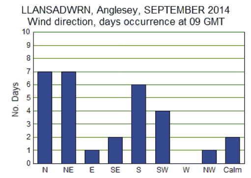
| Mean maximum | 19.2 | 2.2 | 1.9 | Sleet/ snow falling | 0 | 0.0 | N | 7 | Total | 14.7 | 13 | 15 | % | ||||||||||||||||||||||
| Mean minimum | 11.4 | 0.4 | 1.1 | Snow lying (at 09 GMT) | 0 | 0.0 | NE | 7 | Largest fall | 9.6 | |||||||||||||||||||||||||
| ~ | Mean (max+min)/2 | 15.3 | 1.3 | 1.5 | Hail <5 mm | 0 | -0.9 | E | 1 | ||||||||||||||||||||||||||
| Highest maximum | 23.7 | 0.8 | Hail >=5 mm | 0 | {All types} | SE | 2 | Evaporation (mm) | |||||||||||||||||||||||||||
| Lowest maximum | 15.9 | 3.7 | Thunder heard | 0 | -0.3 | S | 6 | Lysimeter | PE | 34.3 | |||||||||||||||||||||||||
| Highest minimum | 15.7 | 0.6 | Gales | 0 | n.a. | SW | 4 | Monthly total | PWB | -19.6 | |||||||||||||||||||||||||
| Lowest minimum | 8.2 | 1.4 | Fog (at 09 GMT) | 0 | n.a. | W | 0 | PWS | 12.1 | ||||||||||||||||||||||||||
| No. days <0.0C | 0 | 0.0 | Rainfall (No. days occurrence) | NW | 1 | PWD | -31.7 | ||||||||||||||||||||||||||||
| Grass minimum mean | 7.6 | -0.9 | No pptn | 0.0 mm | 20 | 12.2 | Calm | 2 | AWS | ET | 42.4 | ||||||||||||||||||||||||
| Lowest minimum | 3.4 | 0.5 | Dry | < 0.2 mm | 24 | 16.2 | Piche | P I | 46.0 | ||||||||||||||||||||||||||
| No. days <0.0C | 0 | 0.0 | Rain | >= 0.2 mm | 6 | -11.7 | Check days | 30 | |||||||||||||||||||||||||||
| Earth temperature 30cm | 16.0 | 1.1 | Wet | >= 1.0 mm | 2 | -11.0 | This month | 30 | Days max >=20C | 9 | |||||||||||||||||||||||||
| >= 5.0 mm | 1 | -6.1 | Days max >=25C | 0 | |||||||||||||||||||||||||||||||
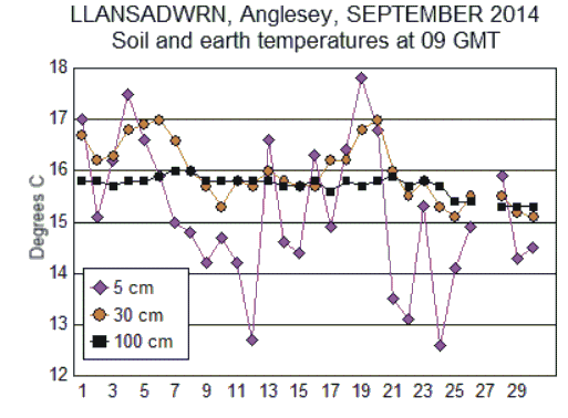
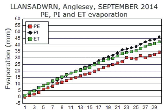
Note: Unusual peaks seen on the PE graph are due to recent rainfalls or unmelted snow having not yet percolated through the soil. This method is not good for daily measurements, but good results are obtained over 3 days (allowing time for percolation) and on a monthly basis. The lysimeter also measures dew and depositions of frost, and is a better raingauge than one with a rim at 30 cm high. In winter, when evaporation from the ground is low, negative values are sometimes seen and indicate an accumulation of dew and frost, and more rain than measured by a standard raingauge. In summer, when evaporation is high and rainfall less, the lysimeter still measures dew and more rain than the standard gauge, but the effect is less noticeable. The daily graph is show here for it's interest and you can read more about this 'classic' method of measuring evaporation here
.
DD date; N cloud (oktas, 9=obscured); DD wind direction (8 sectors, 00=calm); ff wind speed (Beaufort scale); V visibility (0 dense fog, 1 thick fog, 2 fog, 3 moderate fog, 4 very poor, 5 poor, 6 moderate, 7 good, 8 very good); WW present weather SYNOP code (eg. 01 cloud decreasing, 02 sky not changing, 03 cloud increasing, 04 smoke haze, 05 haze) Temperatures (degC); Temp dry bulb temperature; Dpt dewpoint; RH relative humidity (%); soil temperatures are under bare soil and earth under grass; SS snow depth (cm); Press air pressure, aneroid (mb). For state of the ground E, concrete C, and grass Gr codes consult the page on 'Recording Atmospheric Depositions on Grass'. 24 hour observations... Max maximum temperature (degC) beginning 09GMT; Min minimum temperature ending 09GMT; Gmin grass minimum temperature (degC) ending 09GMT; Pch Evap Piche evaporation (ml) beginning 09GMT; Rain rainfall beginning 09GMT (mm); Pptn W hrs number of hours with precipitation 09-09GMT; trace <0.05 mm; tr trace of rain; tr dw trace of dew; tr fr trace of frost; Fr. hrs hours of frost (09-09GMT). Sol MJ/m2 Global Solar Radiation (MJ per m2) 00-00 GMT. Monthly observations... PE Potential evapotranspiration, PWB Potential water balance, PWS Potential water surplus, PWD Potential water deficit. Weather: days with... s slight or S heavy snow/sleet falling; L >=50% snow cover at 09GMT; H categories of hail: 1 ice crystals, 2 snow grains, 3 snow pellets, 4 ice pellets, 5 hail 5-9 mm, 6 hail 10-19 mm; up unidentified precipitation; t slight or T heavy thunder heard; G gale; Fog any hour 1, 09 GMT 9. Gales (Beaufort land scale) refer to the area. |
These pages are designed and written by Donald Perkins © 2014http://www.llansadwrn-wx.info
|