Llansadwrn (Anglesey) Weather:
Snowdonia Snowline Report


| Llansadwrn (Anglesey) Weather:
|

|
|
|

|
October
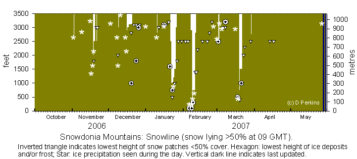
Snow fell in Scotland on the 27th at 4000 ft on Cairngorm, but it soon melted. With cold air from the Arctic reaching Scotland overnight 30/31 there was some more snow. The colder but drier air reached North Wales by the end of the day but, regrettably, no snow was seen. A few flakes were reported on the Pennines.
November
With temperatures just below freezing on the summits on the 2nd, showers drifting in off the Irish Sea at dawn brought the first sprinkling of snow lying above 2700 ft. But it did not last long and had disappeared by afternoon. The 3rd was frosty but there was no snow. Ice precipitation was seen high on the northern slopes of the Carneddau on the afternoon of the 9th. No snow seen up to the morning of the 15th. There were remnant patches left on Cairngorm on the 13th. With colder air heading south on Friday 16th there was snow on Cairngorm and blustery wintry showers in Snowdonia; a little ice precipitation was seen on the summit of Carnedd Llewelyn at dusk (1640 GMT). There was more precipitation overnight and by the morning of the 18th snow was lying thinly as low as 2000 ft on the northern slopes, and a little at the foot of the Black Ladders. With more snow showers overnight 18/19th and early in the day snow was lying at 2000 ft on the 19th, and a little lower in some places. But with temperatures rising again and heavy overnight rain 19/20th little was left by morning. There was a slight fall of snow overnight 20/21st and it was lying at 2500 ft on the 21st, but little remained on the 22nd and none that I could see on the 23rd. There was no further snow to the end of the month.December
There was a sprinkling of ice precipitation on the summit of Carnedd Llewelyn at 09 GMT on the 3rd. With Atlantic-storms continuing to move across Britain from the west, below a strong jetstream, temperatures continue to be influenced by the ocean's relative warm waters. Freezing levels on the 7th were about 4000 ft, well above the Snowdonia summits, but continuing to bring snow on the tops of the Cairngorms in Scotland. Snow is also at a premium in Europe with many alpine areas having none at all as yet. Conditions were right for some snow on the 8th, but the mountains were obscured in cloud and mist above 2500 ft. There was no clearance later in the day and conditions were similar on the 9th. Visibility of the summits remained poor, but ice precipitation was seen as low as 1500 ft during the afternoon on some north-western slopes. Above average temperatures continued until the 15th when, by morning, temperature were lower, but still above freezing on the summits. As the temperature dropped overnight there was a little snow. Slight snow was lying on the tops of the Carneddau, mostly hidden in cloud, up to the morning of the 18th. Clear skies resulted in frost overnight 18/19th to low levels and kept the light snow cover above about 3100 ft on the Carneddau. A clear view of Snowdon on the 19th, for the first time in days, revealed somewhat thicker looking cover down to 2800 ft on the NW-facing slopes of Crib-y-ddysgl and Crib-goch. There were remnants scattered on some summits until the 21st when temperatures were rising in mid-altitude with inversion conditions prevailing. But small amounts of ice remained as the freezing level occasionally descended again 23/24th. On the morning of the 24th the mountaintops above 2800 ft were in the clear above the inversion cloud and fog and this persisted all day. On the 25th the tops were in cloud most of the time and by the 26th cloud had lifted from the lower slopes but at 09 GMT was on most peaks, but a little icy deposit was seen on the top of C. Llewelyn. A clearer view on the 27th showed icy deposits remaining at 3100 ft on C. Llewelyn, C Dafydd and the Glyders, Snowdon was obscured. By the 28th temperatures were rising again, there was no snow on the mountains at the end of the month.
JanuaryThere were ice precipitation showers on the summits after midnight on the 1st but with temperatures above average and freezing levels above the summits the first 9 days were without snow. Overnight on the 9/10th temperature dropped after passage of a cold front and latterly precipitation fell as snow leaving a thin covering above 2800 ft on the 10th. This soon disappeared and up to the 16th there was no snow seen on the ground. On the 17th with freezing levels descending to just below the summits a 'dusting' of ice precipitation was seen on the tops of Carnedd Llewelyn and C. Dafydd during the afternoon. Overnight there was more snow, but by the 18th only patches remained in north-facing gullies near the summits. These were still to be seen on the morning of the 19th, but had disappeared by the 20th. Overnight 20/21st there was ice precipitation and slight deposits lay generally on the summits above 2500 ft on the morning of the 21st. In places it was lower being 1600 ft at the Black Ladders and 2000 ft in Cwm Idwal. Overnight 21/22nd further snow brought the snowline down to 1000 ft, but there was a sprinkling as low as 500 ft in the Ogwen valley early on the 22nd. On the 23rd there was snow as low as 750 ft and wind-blown moderate accumulations in places. There was a little wet snow overnight 23/24th this gave a sprinkling over previous thawed areas with patchy remnants on lower slopes. The general snowline had risen to 1200 ft on the 24th, but was a little lower near Ogwen Cottage. Snowline on the 25th was 1500 ft with some as low as 1000 ft in central parts, some areas on the northern slopes to E and W were starting to look patchy and more thawed during the day. By the 26th temperatures had risen and snow under 1800 ft had mostly disappeared, the tops were obscured in cloud so were unseen. On the 27th there were frequent large snow patches from 1800 ft upwards on the N slopes of the Carneddau. On the 29th and 30th there were frequent patches remaining, especially in gullies, from 2500 ft upwards some of these lasted to the end of the month.
February
Numerous small patches of snow remained in gullies across the range on north-facing slopes but diminished in size daily. Freezing level was forecast to be above the summits for the weekend 3/4th, and with cold air moving S again there was a chance of some wintry showers. Snow pellets and snow showers brought a sprinkling of snow to low levels from central and SE Anglesey (up to 2 cm reported in a few places) to the Carneddau on the morning of the 6th. Most snow, a thin cover persisting through the day, was on Foel-fras and Drum and least around Crib-y-ddysgl and Yr Wyddfa soon disappearing. Models were showing the possibility of significant (moderate to heavy) snowfall overnight Wednesday/Thursday 8th and possibly a little more on Saturday 10th.
 On the 8th there was light snow cover upwards from about 500 ft in places on the lower slopes of the Carneddau which were obscured in cloud from about 1200 ft. More snow fell during the day and overnight on the summits adding to the already light to moderate accumulations. On the 9th snow cover was generally above 750 ft with ice in places; there were further snow showers through the day. As predicted, there was further snow on the morning of the 10th as low as 500 ft (wet) with further moderate accumulations above 2000 ft. There were deep accumulations even with some cornices developing on some ridges on the Carneddau in the E'ly wind. But, temperatures rose during the morning and this led to a rapid thaw even at higher levels. At 15 GMT, with temperatures at lower levels approaching 10C, the snow was already looking very patchy up to mid levels, but there was good cover around the summits at 17 GMT. On the 11th most remaining snow on the Carneddau was on slopes between Foel-fras and Foel-grach, with frequent patches, some moderately large, down to 2000 ft and small patches as low as 1400 ft. By the 12th, although there were frequent snow patches, cover was down at best to 40%, and on the 13th the lowest (smaller) patches were at 2200 ft. By the 16th the lowest gully remnant was about 2500 ft while larger patches were above 2800 ft. Patches slowly reduced in size, but were still there on the 23rd. By the 26th small patches were present at 3200 ft, NE side of C. Llewelyn and elsewhere. There was an ice deposition dusting above 2900 ft on the Carneddau and Snowdon. On the 28th snow appeared absent.
March
The month began with temperatures on the summits falling just below 0C at noon. Most summits in showery weather were cloud covered, but slight ice precipitation was seen on Drum and Foel-fras at 1630 GMT. On the 2nd with a little more precipitation overnight snow was lying thinly as low as 2450 ft in some places on the Carneddau, but most had disappeared by mid-afternoon. Early low cloud cleared on the 3rd to reveal an isolated white cap on C. Llewelyn during the afternoon. There was further ice precipitation from showers seen on the ground above 2800 ft on the 5th. On the 6th there was remnant snow and gully patches on the NW flank of C. Llewelyn with small patches seen on the 7th. There was a little fresh ice precipitation on C. Llewelyn on the 8th, but none was seen on the 9th. On the 14th snow was absent, but models accurately forecast that by Sunday 18th colder Arctic air would bring some snow. There were frequent snow showers during the afternoon of the 18th that left a sprinkling of snow as low as 500 ft in places. On the 19th there was light snow lying generally at 750 ft but was as low as 400 ft in the Nant Ffrancon Pass near Bethesda and about 800 ft in the Llanberis Pass. Snow showers continued around the summits but by the end of the day the snowline had risen to 1500 ft. On the 20th snow was lying with light to moderate cover at 1500 ft, but was as low as 1000 ft at Ogwen, lasted until the 21st. As an Atlantic-frontal system moved across in the evening there was initial snow, but with temperatures rising soon turned to rain leaving remnants by the 22nd. Some small patches remained until the 29th when fresh snow was seen on the summits.
AprilNo snow was seen falling during the month, but I received a report that a small pocket of snow was seen on the eastern flank of Carnedd Llewelyn as late as the 14th.
¤

|
You can view the snowline histograms for previous years here:
![]() Winter 2005-2006
Winter 2005-2006
![]() Winter 2004-2005
Winter 2004-2005
![]() Winter 2003-2004
Winter 2003-2004
You can view complete snowline reports for previous years here:
![]() Winter 2005-2006
Winter 2005-2006
![]() Winter 2004-2005
Winter 2004-2005
![]() Winter 2003-2004
Winter 2003-2004
![]() Latest reports may be found in my daily weather diary
Latest reports may be found in my daily weather diary
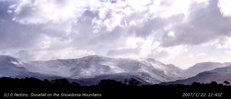
Observations were made as near to 0900 GMT as possible. I have a good view from Llansadwrn, weather permitting, across the Menai Strait towards the Snowdonia Mountains. I can see the northern slopes of the mountain range from Moel Eilio (west of Snowdon), Snowdon summits (Yr Wyddfa and Crib Goch), the Carneddau and to Foel-fras and Drum on the eastern end near the Conwy Valley. With the aid of binoculars I make daily records that include any ice precipitation observed, the lowest altitude of snow lying (>50% cover) and any patchy cover (<50%).
These pages are designed and written by Donald Perkins, Copyright © 1998 - 2007. All Rights Reserved.Document dated 1 October 2006http://www.llansadwrn-wx.co.uk |