Llansadwrn (Anglesey) Weather:
Snowdonia Snowline Report

 | Llansadwrn (Anglesey) Weather: |

|


|
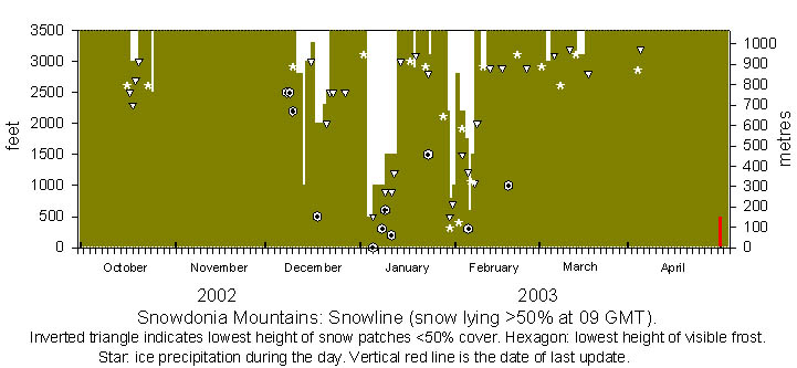
The first snow of the season, the earliest in 4 years, fell overnight on the 16/17th October and was lying thinly at 3000 ft on the Carneddau, Crib Goch and Yr Wyddfa on the morning of the 17th. Further snow that fell in showers, mainly on Snowdon and the Llanberis Pass, was lying at 2500 ft on the 18th and 2300 ft on the 19th whereas it was confined to 3000 ft and above on the Carneddau. More fell on the 20th ahead of rain but, as the temperature rose in warm sector air, most had melted by the 21st. Wintry conditions soon returned as on the 23rd when NW'ly winds brought showers in cold air from Scandinavia. Sprinklings of snow were seen across the summits in the afternoon and it was lying thinly at 2500 ft on the 24th. No further snow was seen in the month.
November was mild and no lying snow was seen in the month. There was snow in November in the previous 3 years.
December also began mild but the weather turned colder on the 6th. Temperatures on the summits were below freezing from the 7th. Frost was seen on the 9th and remained all day above 2500 ft, even in sunshine, and was lower in places in shadow. The cold weather persisted with freezing temperatures; wintry showers from the 10th led to small accumulations from the 11th, mainly above 2800 ft but lower in places. Further light snow lay at 1000 ft on the 13th but this thawed in rising temperatures to the 15th. The weather turned colder again and brought fresh snow lying at 2000 ft on the 17th that lasted 2 or 3 days before rising temperatures melted most by the 22nd. On the 23rd there were snow patches left only in gullies. It seems that the on/ off nature of the cold weather continues that seen last year. The weather remained mild over Christmas/ New Year but turned colder on the 2 January with wintry showers on the summits. Precipitation during the night 2/3rd gave light snow lying at 500 ft in the Nant Ffrancon Pass and slight-moderate accumulations in places above 2500 ft on the Carneddau on the morning of the 3rd. Snow was much thinner around Snowdon and the Llanberis Pass and was absent further W. Temperatures remained below freezing, with a significant wind-chill, for several days and there was snow lying thinly generally at 1500 ft and at 900 ft at Cwm Idwal on the morning of the 9th and remained until the 12th. When the weather turned milder from the N on the 13th the snow had melted by the 15th. A colder interlude produced snow showers on the summits on the 17th with snow lying briefly at 2900 ft on the 18th. It remained mild until the 22nd when there were wintry showers around the summits that gave thin snow lying fleetingly at 3100 feet on NW-facing slopes on the 23rd. Cold showery weather on the 28th brought wintry precipitation to the summits and slight lying snow above 2200 ft on the morning of the 29th. Further snow fell in the early hours of the 30th giving a light covering as low as 500 ft and was still lying above 800 ft on the 31st.
Fresh snow fell overnight on 1/2nd February with snow lying generally at 2200 ft but as low as 1500 ft at Cwm Idwal on the morning of the 2nd. Further light snow fell on the 3/4th and was lying generally at 1750 ft, as low as 1300 ft in places, on the morning of the 4th. Further light snow brought the snowline to 600 ft on the morning of the 5th. Despite further sprinklings by the 7th cover was sparse and over 2000 ft. Precipitation was heavy on the 8/9th but cold enough only above 2800 ft for snow to fall during the latter stages. Sprinklings occurred during the 9th with snow lying at 2800 ft on the morning of the 10th but this soon melted in warm sunshine by the afternoon of the 11th. There was no further significant snow to the end of the month with only small amounts lingering in some shaded gullies.
March 1st saw heavy precipitation, on an active trough over Snowdonia, while most fell as rain there was snow late in the afternoon above 2500 ft. There was a light covering on summits over 3000 ft on the mornings of the 2 - 3rd but by the 4th was patchy and sparse. There were snow showers across the summits on the 11th with a thin covering of snow above 3000 ft on the 12th mostly on Yr Wyddfa and Crib Goch, with Carnedd Dafydd and C. Llewelyn having least. Cover lasted until the 14th with only patches remaining by the 15th and these disappeared before the end of the month.
Colder weather returned on 31st March and there were wintry showers around the summits overnight on 31 March/1 April. Sprinklings of snow were seen above 3200 ft on the morning of the 2nd but there was little left by the end of the day. No further lying snow was seen.

|
Click on icons below for pop up graphic but please close each after viewing.
![]() Snowdonia snowline: Winter 2001-2002
Snowdonia snowline: Winter 2001-2002
![]() Snowdonia snowline: Winter 2000-2001
Snowdonia snowline: Winter 2000-2001
![]() Snowdonia snowline: Winter 1999-2000
Snowdonia snowline: Winter 1999-2000
Observations are made as near to 0900 GMT as possible. I have a good view from llansadwrn, weather permitting, across the Menai Strait, towards the Snowdonia Mountains. I can see the northern slopes of the mountain range from Moel Eilio (west of Snowdon), Snowdon summits (Yr Wyddfa and Crib Goch), the Carneddau and to Foel-fras and Drum on the eastern end near the Conwy Valley. With the aid of binoculars I make records of the lowest altitude of snow lying (>50% cover) and any patchy cover (<50%). The diagram is updated at least weekly, usually on Monday and Thursday during the season. Daily reports can be found in my weather diary.
These pages are designed and written by Donald Perkins, Copyright © 2002-2003Document dated 7 August 2002http://www.llansadwrn-wx.co.uk |